Digital Image: 1859 Arrowsmith Map of Nunavut, Baffin's Bay, Search for Franklin Expedition Remains
ArcticShores-arrowsmith-1859_d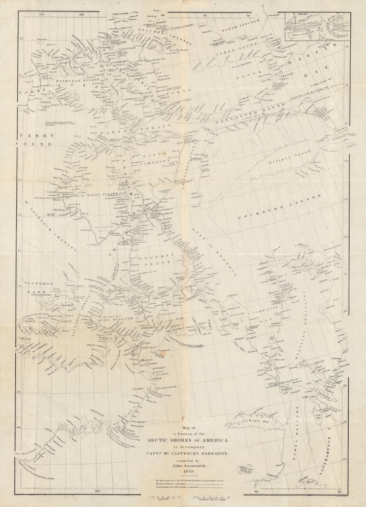

Title
Map of a portion of the Arctic shores of America to accompany Captn. McClintock's narrative.
1859 (dated) 19.5 x 14 in (49.53 x 35.56 cm) 1 : 3000000
1859 (dated) 19.5 x 14 in (49.53 x 35.56 cm) 1 : 3000000
Description
FOR THE ORIGINAL ANTIQUE MAP, WITH HISTORICAL ANALYSIS, CLICK HERE.
Digital Map Information
Geographicus maintains an archive of high-resolution rare map scans. We scan our maps at 300 DPI or higher, with newer images being 600 DPI, (either TIFF or JPEG, depending on when the scan was done) which is most cases in suitable for enlargement and printing.
Delivery
Once you purchase our digital scan service, you will receive a download link via email - usually within seconds. Digital orders are delivered as ZIP files, an industry standard file compression protocol that any computer should be able to unpack. Some of our files are very large, and can take some time to download. Most files are saved into your computer's 'Downloads' folder. All delivery is electronic. No physical product is shipped.
Credit and Scope of Use
You can use your digial image any way you want! Our digital images are unrestricted by copyright and can be used, modified, and published freely. The textual description that accompanies the original antique map is not included in the sale of digital images and remains protected by copyright. That said, we put significant care and effort into scanning and editing these maps, and we’d appreciate a credit when possible. Should you wish to credit us, please use the following credit line:
Courtesy of Geographicus Rare Antique Maps (http://www.geographicus.com).
How Large Can I Print?
In general, at 300 DPI, you should at least be able to double the size of the actual image, more so with our 600 DPI images. So, if the original was 10 x 12 inches, you can print at 20 x 24 inches, without quality loss. If your display requirements can accommodate some loss in image quality, you can make it even larger. That being said, no quality of scan will allow you to blow up at 10 x 12 inch map to wall size without significant quality loss. For more information, it is best consult a printer or reprographics specialist.
Refunds
If the high resolution image you ordered is unavailable, we will fully refund your purchase. Otherwise, digital images scans are a service, not a tangible product, and cannot be returned or refunded once the download link is used.
Cartographer S
Aaron Arrowsmith (1750-1823), John Arrowsmith (1790-1873), and Samuel Arrowsmith. The Arrowsmith family were noted map engravers, publishers, geographers, and cartographers active in the late 18th and early 19th century. The Arrowsmith firm was founded by Aaron Arrowsmith, who was trained in surveying and engraving under John Cary and William Faden. Arrowsmith founded the Arrowsmith firm as a side business while employed by Cary. The firm specialized in large format individual issue maps containing the most up to date and sophisticated information available. Arrowsmith's work drew the attention of the Prince of Wales who, in 1810, named him Hydrographer to the Prince of Wales, and subsequently, in 1820, Hydrographer to the King. Aaron Arrowsmith was succeeded by two sons, Aaron and Samuel, who followed him in the map publication business. The Arrowsmith firm eventually fell to John Arrowsmith (1790-1873), nephew of the elder Aaron. John was a founding member of the Royal Geographical Society. The firm is best known for their phenomenal large format mappings of North America. Mount Arrowsmith, situated east of Port Alberni on Vancouver Island, British Columbia, is named for Aaron Arrowsmith and his nephew John Arrowsmith. More by this mapmaker...
The Old Corner Book Store (1828 - 1950) of 27-29 Bromfield Street is one of Boston's oldest and most historic locations. The structure that the Book Store occupied, still called the Old Corner Book Store, was originally built in 1712 as an apothecary shop. In 1828 Carter & Hendee took over the space and reinvented it as a bookshop. Later it fell into the hands of publishers Ticknor and James Fields. On November 12, 1864, shortly after Ticknor died, Fields sold the Old Corner Bookstore to E. P. Dutton. Dutton ran the business until his own retirement in 1869, when Alexander Williams took over the space, running it as A. Williams Publishers, Booksellers and Importers until his own retirement in 1883. In the 1890s it served as a magazine store. Such important literary giants as Henry Wadsworth Longfellow, James Russell Lowell, Henry David Thoreau, Ralph Waldo Emerson, Nathaniel Hawthorne, and Harriet Beecher Stowe were known to frequent the establishment. Due to its many literary connections, this shop published some of the most important American books ever written, including The Scarlet Letter, Walden, and the Atlantic Monthly Magazine. The space remained open as a bookstore for nearly 100 years before closing c. 1950. For a time it was converted to a parking garage until acquired by Historic Boston, Inc., who preserved it. Today the Globe Bookstore, in Harvard Square is considered its successor. The Old Corner Book Store building has been fully restored as a historic monument and is currently occupied by a jewelry store. Learn More...
John Murray I (1737 - 1793) founded the British publishing firm John Murray (1768 - present) in London. Born in Edinburgh, Murray served as an officer in the Royal Marines and built a list of authors that included Isaac D’Israeli and published the English Review. Murray the elder also was one of the founding sponsors of the London evening newspaper The Star in 1788. John Murray II (November 27 1778 - June 27, 1843) continued the family publishing business and developed it into one of the most important and influential publishing houses in Britain. The list of authors published by the firm grew to include Jane Austen, Sir Walter Scott, Washington Irving, George Crabbe, and Lord Byron under his tenure. Murray II also moved the business to 50 Albermarle Street in Mayfair, which became famous for Murray’s tradition of ‘four o’clock friends’, which was afternoon tea with his writers. John Murray III (1808 - 1892) continued to grow the business, and the firm published the first English translation of Goethe’s Theory of Colours, David Livingstone’s Missionary Travels and Charles Darwin’s Origin of Species during his tenure. Murray also published Herman Melville’s first two books. The firm began publishing Murray Handbooks in 1836, an ancestor of all modern travel guides. Sir John Murray IV (1851 - 1928) was publisher to Queen Victoria. Three successive Murray’s after Murray IV led the business until it was purchased by Hodder Headline in 2002, which was acquired by the French conglomerate Lagardère Group in 2004. Today, Murray is an imprint of Lagardère under the imprint Hachette UK. Learn More...
Source
McClintock, F.L., The Voyage of the 'Fox' in the Arctic Seas: A Narrative of the discovery of the fate of Sir John Franklin and his companions, (Boston: Ticknor and Fields) 1860.
References
OCLC 1007201173.