This item has been sold, but you can get on the Waitlist to be notified if another example becomes available, or purchase a digital scan.
1853 Cabrer Map of the Argentine Confederation, Uruguay, and Paraguay
ArgentinaUruguayParaguay-cabrer-1853$3,000.00


Title
Carta esferica de la confederacion Argentina y de las republicas del Uruguay y del Paraguay.
1853 (dated) 40 x 27 in (101.6 x 68.58 cm) 1 : 2000000
1853 (dated) 40 x 27 in (101.6 x 68.58 cm) 1 : 2000000
Description
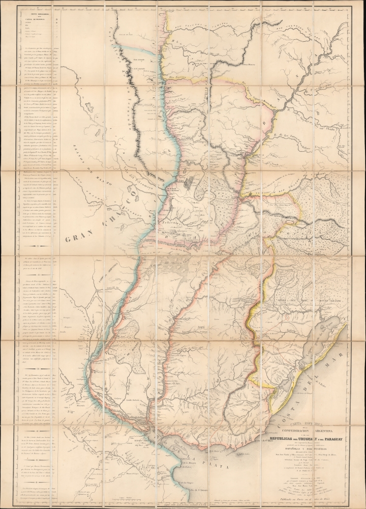
This is the sole edition of Jose Maria Cabrer's 1826 map of the Argentine Confederation, Paraguay, and Uruguay, based on his surveys executed between 1777 and 1802. Despite its excellence, it was not published during the author's lifetime and did not appear in print before this Paris edition of 1853. The original manuscript has not survived. Cabrer, a Spanish military engineer, had been assigned to survey the borders of the Spanish and Portuguese empires in South America following the 1777 Treaty of Ildefonso; the present work encapsulates two decades of arduous, well-respected surveys, compiled 'unofficially' by Cabrer in 1802.
During the war of independence, the United Provinces lost both Bolivia and Paraguay; the Banda Oriental would be invaded and annexed by Brazil in 1816, ultimately resulting in the revolt of that region against Brazil and the formation of Uruguay.
The publication of this map in Paris in 1853, more than half a century after the surveys that formed its basis, took place in 1852, just after the Argentine Confederation came to an end with Buenos Aires seceding. In this phase of Argentina's civil wars, Buenos Aires' Unitarians fought against a Federalist party led by General Justo de Urquiza. Upon taking power in 1852, Urquiza formed an assembly to write a national constitution, an important step in forming a unified Argentina. It is supposed that Urquiza, having had this map brought to his attention with his accession to power, sent it to be published as an expression of the unity of the new Argentine Republic. Nonetheless, it is more accurate to view the map as an expression of Argentine territorial ambitions, displaying the Rio de la Plata region as it was before the loss of Bolivia, Paraguay, and the Banda Oriental.
The Platine War (1851 - 1852), between the Argentine Confederation and Paraguay, was also fought at this time. The war ended with a July 19, 1852 treaty, which, as conclusions go, was less than conclusive: the Misiones Province southeast of the Paraná River was assigned to Argentina but was in practice administered by Paraguay, Argentina having refused to ratify the treaty. Claims to the territory remained a sticking point between the countries. The surveys undertaken following the 1777 treaty setting the boundaries between Spain and Portugal were considered - particularly by Argentine authorities - to be authoritative, particularly in the Misiones province. (Cabrer's 1790 reconnaissance of the eastern extreme of the Missiones Province was particularly miserable, finally 'arriving at the town of Santo Ángel, with our entire party in the greatest misery and nakedness, with their legs swollen, the body covered with sores, and the beards long like anchorites.') The map would continue to be referenced by Argentina in boundary arbitrations pertaining to Misiones as late as 1893.
A Closer Look
The map encompasses the broad reach of the Rio de la Plata Region, from Cabo de S. Antonio in the south, as far north as the Rio Taquari in Brazil. Its detail is best east of the Rio Parana, detailing the part of the Argentine Confederation found north of the Plata, Uruguay, Paraguay, and the southernmost provinces of Brazil. To the west in the Gran Chaco, a few settlements and missions appear scattered along speculatively delineated rivers. Along the left border of the map is a historical gloss of Spanish surveys that took place following the 1777 Treaty of Ildefonso. The treaty granted Spain the Colonia do Sacramento and the Banda Oriental - the region east of the Uruguay River, including the Misiones Orientales. The borders were poorly defined in the treaty, necessitating better surveys to determine what exactly the treaty meant. The abundant detail resulting from Cabrer'a survey includes specific notations regarding the territorial borders of the Spanish and the Portuguese Empires at the beginning of the 19th century.History Looms
Although the Argentine Confederation, Paraguay, and Uruguay are named in the title, the original for this map was drawn up before their actual existence: Paraguay, for example, did not declare independence until 1811; Uruguay, 1825. The Argentine Confederation was established in 1831. When the surveys were made, the region depicted here largely corresponded to the Spanish colonial Viceroyalty of Rio de la Plata. Following the declaration of independence from Spain, it became known as the United Provinces of Rio de la Plata. This territory included what is now Bolivia, Paraguay, and Uruguay.During the war of independence, the United Provinces lost both Bolivia and Paraguay; the Banda Oriental would be invaded and annexed by Brazil in 1816, ultimately resulting in the revolt of that region against Brazil and the formation of Uruguay.
The Relevance of 18th Century Surveys in 1853
It is perhaps less puzzling that Cabrer did not publish the map than it is that it would be printed as late as it was. Up until the 1810 revolution, he was an officer of the Spanish Empire. The history between then and the establishment of the Confederation was one of civil war. Throughout this period, Cabrer seems not to have held a position that would support the publication of such a work. The 1826 date given for Cabrer's delineation corresponds with Uruguay's independence, so it may be that regional political changes suggested that Cabrer take up the project again. By the time he was appointed to the Topographical Department of the new Argentine Confederation in 1831, he might have been able to move forward but did not, and by 1836 he was dead.The publication of this map in Paris in 1853, more than half a century after the surveys that formed its basis, took place in 1852, just after the Argentine Confederation came to an end with Buenos Aires seceding. In this phase of Argentina's civil wars, Buenos Aires' Unitarians fought against a Federalist party led by General Justo de Urquiza. Upon taking power in 1852, Urquiza formed an assembly to write a national constitution, an important step in forming a unified Argentina. It is supposed that Urquiza, having had this map brought to his attention with his accession to power, sent it to be published as an expression of the unity of the new Argentine Republic. Nonetheless, it is more accurate to view the map as an expression of Argentine territorial ambitions, displaying the Rio de la Plata region as it was before the loss of Bolivia, Paraguay, and the Banda Oriental.
The Platine War (1851 - 1852), between the Argentine Confederation and Paraguay, was also fought at this time. The war ended with a July 19, 1852 treaty, which, as conclusions go, was less than conclusive: the Misiones Province southeast of the Paraná River was assigned to Argentina but was in practice administered by Paraguay, Argentina having refused to ratify the treaty. Claims to the territory remained a sticking point between the countries. The surveys undertaken following the 1777 treaty setting the boundaries between Spain and Portugal were considered - particularly by Argentine authorities - to be authoritative, particularly in the Misiones province. (Cabrer's 1790 reconnaissance of the eastern extreme of the Missiones Province was particularly miserable, finally 'arriving at the town of Santo Ángel, with our entire party in the greatest misery and nakedness, with their legs swollen, the body covered with sores, and the beards long like anchorites.') The map would continue to be referenced by Argentina in boundary arbitrations pertaining to Misiones as late as 1893.
Publication History and Census
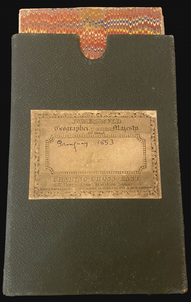
This map was lithographed in 1853 in Paris by the engraver Delamare for publication by the publisher Bineteau. The present example was sold by J. Wyld, mapseller and publisher in London; the original slipcase bears the Wyld stamp, and the lower margin has the Wyld address in a paste-down. We are aware of ten copies cataloged by institutional collections.Cartographer
Jose Maria Cabrer (1761 - 1836) was a Spanish military engineer and geographer. Born in Barcelona, the son of a military engineer Carlos Cabrer y Suñer. He studied engineering at the Royal Academy, and was a student of cartographer Félix de Azara (as well as his own father.) With the onset of the American Revolution, he set aside the academy to join Spanish naval efforts to support America against the British Empire. Initially targeted at Jamaica, he was sent instead to the Buenos Aires as attaché of the Royal Corps of Engineers to assist in demarcating the boundary of Spanish territory in South America with Brazil. He arrived there in 1781, then completing his training as a cartographer. In 1783, with the military rank of Captain, he surveyed the border region of the Banda Oriental, which would largely become Uruguay. He would become a commissioner and geographer of the second demarcation party under Diego de Alvear, reconnoitering the Paraná River and the course of the Uruguay River. In 1789, he surveyed the Pepirí Guazú River, the middle of the border set by the Treaty of San Ildefonso (1777). He returned to Buenos Aires as a Lieutenant Colonel in 1801, where he would choose to stay upon learning of the deaths in Spain of his father and brothers. He settled and married a barber's daughter over the objections of his superiors, who thought the match below him. The following twenty years seem to have been, politically, poorly navigated: following the Revolution of 1810 he was appointed to direct a mathematics academy, but the project did not proceed; he would be appointed secretary to the Argentine General Staff, but he refused the position. In 1831 following the estblishment of the Argentine Confederation, he accepted a posting to the Topographical Department, but did not enjoy the position long: He died in 1836 as the result of an improperly prescribed medicine. Although many of his boundary commission maps would be published, his superb 1802 he map of the La Plata region, including Uruguay and Paraguay, would not be published until 1853 in a Paris edition. More by this mapmaker...
Condition
Excellent. Dissected and mounted on linen as sold, in original slipcase.
References
OCLC 1264680769.