
This copy is copyright protected.
Copyright © 2025 Geographicus Rare Antique Maps
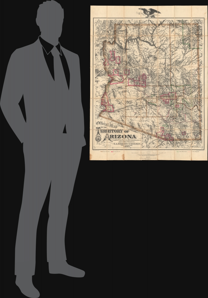
Digital Image: 1880 Eckhoff Official Map of the Territory of Arizona
Arizona-eckhoff-1880_d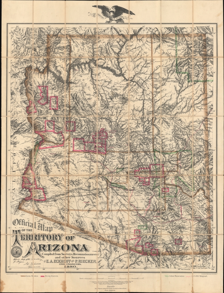

FOR THE ORIGINAL ANTIQUE MAP, WITH HISTORICAL ANALYSIS, CLICK HERE.
Digital Map Information
Geographicus maintains an archive of high-resolution rare map scans. We scan our maps at 300 DPI or higher, with newer images being 600 DPI, (either TIFF or JPEG, depending on when the scan was done) which is most cases in suitable for enlargement and printing.
Delivery
Once you purchase our digital scan service, you will receive a download link via email - usually within seconds. Digital orders are delivered as ZIP files, an industry standard file compression protocol that any computer should be able to unpack. Some of our files are very large, and can take some time to download. Most files are saved into your computer's 'Downloads' folder. All delivery is electronic. No physical product is shipped.
Credit and Scope of Use
You can use your digial image any way you want! Our digital images are unrestricted by copyright and can be used, modified, and published freely. The textual description that accompanies the original antique map is not included in the sale of digital images and remains protected by copyright. That said, we put significant care and effort into scanning and editing these maps, and we’d appreciate a credit when possible. Should you wish to credit us, please use the following credit line:
Courtesy of Geographicus Rare Antique Maps (http://www.geographicus.com).
How Large Can I Print?
In general, at 300 DPI, you should at least be able to double the size of the actual image, more so with our 600 DPI images. So, if the original was 10 x 12 inches, you can print at 20 x 24 inches, without quality loss. If your display requirements can accommodate some loss in image quality, you can make it even larger. That being said, no quality of scan will allow you to blow up at 10 x 12 inch map to wall size without significant quality loss. For more information, it is best consult a printer or reprographics specialist.
Refunds
If the high resolution image you ordered is unavailable, we will fully refund your purchase. Otherwise, digital images scans are a service, not a tangible product, and cannot be returned or refunded once the download link is used.
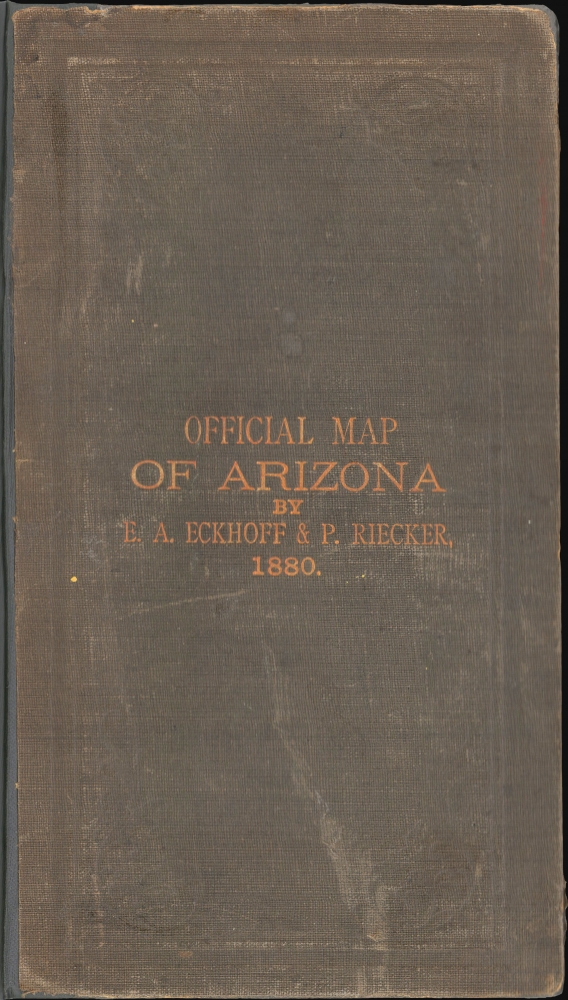
Emil A. Eckhoff (1850 - 19??) was an Austrian-American mineral surveyor, mining engineer, and civil engineer active in Arizona in the late 19th century. Eckhoff was born in Austria. It is unclear when he emigrated to the United States, but it must have been before 1876. He enlisted in the U.S. Army in Philadelphia in 1876 and, upon the expiration of his first term in 1878, re-enlisted in San Francisco. He transferred to Fort Whipple, Arizona, where he served as a Topographical Assistant. Eckhoff was discharged from service in 1800 and settled in Prescott, Arizona, where he worked as a civil engineer and public notary. That same year, he was appointed Deputy U.S. Surveyor and Agent in Central Arizona for the American Bureau of Mines. He is best known for his publication with Paul Reicker (1851 - 1936), in 1880, of the first official map of the Territory of Arizona. He also prepared a map of Prescott, Arizona. Curiously, by May 15th of 1880, Eckhoff and Riecker dissolved their partnership, with Riecker purchasing Eckhoff's interest in the map. Eckhoff went on to work first as an engineer with the Arizona Central Railroad, then with the Southern Pacific Railroad. The date of his death is unknown. More by this mapmaker...
Paul Friedrich Riecker (March 2, 1851 - January 31, 1936) was a German-American explorer, surveyor, civil engineer, and mining engineer. Riecker was born in Baden-Württemberg, Germany. He studied civil engineering at the Hochschule für Technik Stuttgart. He immigrated to the United States between 1870 and 1872 for unclear reasons. He promptly enlisted in the U.S. Army, serving from 1873 to 1880. He led an early exploration party across the Colorado Plateau and was among the first to make contact with the Havasupai at the Grand Canyon. With his civil engineering training, he operated as a draughtsman for the Army in San Francisco until 1876. In 1877, he was reassigned to Fort Whipple, Yavapai, Arizona. Riecker retired from military service in 1880, taking a position in Tucson as a draftsman with the Surveyor' General's Office. In this capacity, along with Emil A. Eckhoff (1850 - 19??), he compiled the first official map of Arizona, published in 1880. Riecker went on to map Pasadena, California, in 1896. He also laid the street plans for both Inglewood and Redondo Beach, California. He was also involved in the Panama-Nicaragua Canal controversy as one of the original surveyors of the Nicaragua Canal route. In his later years, he moved to Oroville, California. Learn More...
Graphic Company (1872 - 1890), or The Graphic Company, was a New York City based printing house in the latter half of the 19th century. The company was founded by the brothers James H. Goodsell and C. M. Goodsell. The Goodsell Brothers were born in Michigan and, for a time, ran a printing business in Chicago, which they lost during the 1871 Great Chicago Fire. They moved to New York in 1872, drawing investors and founding The Graphic Company with $500,000 USD in investment capital, much of it from Canada where it was publically traded. Among their investors were the prominent Republicans Alexander Robey 'Boss' Shepherd and Benjamin Franklin Butler. It was originally created as a newspaper, The Daily Graphic, but quickly expanded to other forms of printing. In 1873, they concocted a publicity stunt to build a giant branded balloon to send aeronauts John Wise and Washington H. Donaldson across the Atlantic in just 60 hours – an attempt that ended in disaster in a Connecticut field just 120 miles from its starting point. By 1874, The Graphic Company advertised as general lithographers, engravers, and power press printers, with specializations in commercial lithography (stock certificates, checks, notes, etc), presentation cards, chromolithography, and photo-lithography. Within a year, they had become a large and successful printing house, largely due to large government printing contracts that may have been dubiously obtained, possibly through investors Sherman and Butler. In 1878, they introduced an additional periodical, The Weekly Graphic. The Goodsells sold their shares in The Graphic Company by at least 1886. By 1888, the company changed its name to the American Graphic Company. In 1889, it was advertised as the Graphic Publishing Company. For most of its operation, the company was located at 39-41 Park Place, New York. The firm was dissolved by court order in March of 1890. The Goodsell Brothers were also, from 1872, publishers of the Financier, a successful financial journal based at 156 and 158 Broadway, and the Insurance Spectator. Learn More...
Copyright © 2025 Geographicus Rare Antique Maps | Geographicus Rare Antique Maps
This copy is copyright protected.
Copyright © 2025 Geographicus Rare Antique Maps