This item has been sold, but you can get on the Waitlist to be notified if another example becomes available, or purchase a digital scan.
1921 General Land Office Wall Map of Arizona showing Reservations
Arizona-landoffice-1821$250.00

Title
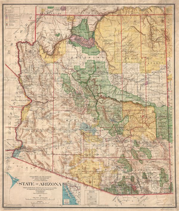
State of Arizona compiled chiefly from the official records of the General Land Office with supplemental data from other map making agencies, under the direction of I.P. Berthrong, chief of drafting division, G.L.O.
1921 (dated) 37 x 31 in (93.98 x 78.74 cm) 1 : 760320
1921 (dated) 37 x 31 in (93.98 x 78.74 cm) 1 : 760320
Description
A remarkable and uncommon 1921 large format map of Arizona prepared by Daniel P. O'Hare and I. P. Berthrong for the General Land Office. This massive map, which covers the entire state as well as adjacent portions its neighbors, is intended to illustrate American Indian Reservations, National Forests, Parks, and other public lands throughout the state. The American Indian Reservations noted and highlighted in yellow include the Apache, Navajo, Kaibab, Hualpai, Fort Mohave, Colorado River, Yuma, Papago, Pima, Gila River, Salt River, and San Carlos. Various national forests are also identified including the Tusayan, Prescott, Sitgreaves, Tonto, Kaibab, Dixie, Apache, Crook, and Coronado, among others. The Grand Canyon, Fort Huachuca, and other federal properties are highlighted in Red. Light blue identified various land reclamation and irrigation projects.
Also identified in the Luis Maria Baca Land Grant. This Grant, issued in 1860 to the heirs to the Vegas Grandes Grant (Las Vegas) in compensation for their original lands. The Luis Maria Baca grant became one of the largest private land grants in the United States and, for a time, was the largest fenced property in the United States. For many years it was operated as massive ranch and was the home of the prized Hereford Cattle.
In addition to the above, this map also offers extraordinary detail throughout identifying countless towns, mountain ranges, peaks, canyons, notable rock formations, passes, rail lines, dry river beds, dry lakes, proposed canals, and mines.
The map was compiled by Daniel P.O'Hare under the supervision of I. P. Berthrong, Drafting Division Chief of the General Land Office. It was printed by the Columbia Planograph Company, based in Washington D.C.
Cartographer
The General Land Office (1812 - 1946) was an independent agency charged with the administration and sale of public lands of the western territories of the United States under the Preemption Act of 1841 and the Homestead Act of 1862. During a time of frenetic energy and rapid westward expansion, the Land Office oversaw the surveying, platting, mapping and eventually the sale of much of the Western United States and Florida. The structural layout of the western United States that we see today, and many of their district and county divisions, are direct result of the early surveying work of the General Land Office. More importantly, as a branch of the Federal Government in Washington D.C. and the only agency able to legally sell and administer public lands in the western territories of the United States, the General Land Office played a pivotal role in consolidating power away from the original states and into the hands of the centralized federal government. The General Land Office was absorbed into the Department of Interior in 1849 and in 1946 merged with the United States Grazing Service to become the Bureau of Land Management. Today the Bureau of Land Management administers the roughly 246 million acres of public land remaining under federal ownership. More by this mapmaker...
Condition
Good. Some soiling and edge wear. Backed on linen. Minor water stain, lower right quadrant.