This copy is copyright protected.
Copyright © 2025 Geographicus Rare Antique Maps
Digital Image: 1700 François Halma Map of Asia
Asia-halma-1700_d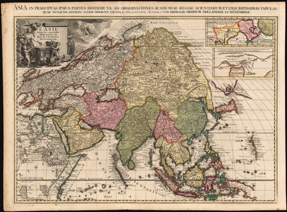

FOR THE ORIGINAL ANTIQUE MAP, WITH HISTORICAL ANALYSIS, CLICK HERE.
Digital Map Information
Geographicus maintains an archive of high-resolution rare map scans. We scan our maps at 300 DPI or higher, with newer images being 600 DPI, (either TIFF or JPEG, depending on when the scan was done) which is most cases in suitable for enlargement and printing.
Delivery
Once you purchase our digital scan service, you will receive a download link via email - usually within seconds. Digital orders are delivered as ZIP files, an industry standard file compression protocol that any computer should be able to unpack. Some of our files are very large, and can take some time to download. Most files are saved into your computer's 'Downloads' folder. All delivery is electronic. No physical product is shipped.
Credit and Scope of Use
You can use your digial image any way you want! Our digital images are unrestricted by copyright and can be used, modified, and published freely. The textual description that accompanies the original antique map is not included in the sale of digital images and remains protected by copyright. That said, we put significant care and effort into scanning and editing these maps, and we’d appreciate a credit when possible. Should you wish to credit us, please use the following credit line:
Courtesy of Geographicus Rare Antique Maps (http://www.geographicus.com).
How Large Can I Print?
In general, at 300 DPI, you should at least be able to double the size of the actual image, more so with our 600 DPI images. So, if the original was 10 x 12 inches, you can print at 20 x 24 inches, without quality loss. If your display requirements can accommodate some loss in image quality, you can make it even larger. That being said, no quality of scan will allow you to blow up at 10 x 12 inch map to wall size without significant quality loss. For more information, it is best consult a printer or reprographics specialist.
Refunds
If the high resolution image you ordered is unavailable, we will fully refund your purchase. Otherwise, digital images scans are a service, not a tangible product, and cannot be returned or refunded once the download link is used.
François Halma (1653 - 1722) was a Dutch publisher active in Utrecht (starting 1674) and later in Amsterdam where he worked as printer and publisher from 1699-1710. He eventually settled at Leeuwarden, where he died. His output was composed of botanical, theological and historical works, but also, he published a small number of geographies and atlases. In 1695, he published an edition of Gerard Mercator's Ptolemy. His re-issue of Schotanus à Sterringa’s Friesche Atlas in 1698 was regarded among his finest work. He also published an edition of Sanson’s Description de l’Univers. He produced an edition of Falda's plan of Rome in or around 1700. He also caused to be engraved a set of large-format maps of the continents and the world (this latter after Cassini) which are quite rare and appear to have been separately issued. We are aware of institutional copies of the continents having been bound into a 1710 Visscher atlas. The execution of these large and rare maps, drawn by Jan Goeree and engraved by Jan Baptiste, was of a very high quality. The plates were later acquired and reprinted, virtually unchanged, by Pieter van der Aa in 1713. More by this mapmaker...
Jan Goeree (1670 - 1731) was a Dutch painter, draughtsman and printmaker. He was also known as a poet. He was the son of one Willem Goeree and no details come down to us of his youth in Middleburg. In Amsterdam he was a pupil of Dutch Golden Age painter and art theorist Gerard de Lairesse. He lived out his life in Amsterdam, the city in which most of his work was produced. His engraving appeared in De Fer's Atlas Royal. Tooley's Dictionary is probably mistaken in saying he worked for Pieter van der Aa. Although his imprint is to be found on van der Aa's large format maps, these were executed on behalf of François Halma as early as 1694, and the plates later acquired and reprinted by van der Aa in 1713. Learn More...
J. Baptist (active late 17th century) was an engraver active in the Netherlands in the latter part of the 17th century and possibly into the early 18th. We see his imprint virtually only in the work of François Halma (any connection with the later work of Pieter van der Aa is extremely tenuous; as the Aa plates attributed to Baptist were actually executed on behalf of Halma and later purchased by the Leiden publisher.) Learn More...
Nicholas de Fer (1646 - October 25, 1720) was a French cartographer and publisher, the son of cartographer Antoine de Fer. He apprenticed with the Paris engraver Louis Spirinx, producing his first map, of the Canal du Midi, at 23. When his father died in June of 1673 he took over the family engraving business and established himself on Quai de L'Horloge, Paris, as an engraver, cartographer, and map publisher. De Fer was a prolific cartographer with over 600 maps and atlases to his credit. De Fer's work, though replete with geographical errors, earned a large following because of its considerable decorative appeal. In the late 17th century, De Fer's fame culminated in his appointment as Geographe de le Dauphin, a position that offered him unprecedented access to the most up to date cartographic information. This was a partner position to another simultaneously held by the more scientific geographer Guillaume De L'Isle, Premier Geograph de Roi. Despite very different cartographic approaches, De L'Isle and De Fer seem to have stepped carefully around one another and were rarely publicly at odds. Upon his death of old age in 1720, Nicolas was succeeded by two of his sons-in-law, who also happened to be brothers, Guillaume Danet (who had married his daughter Marguerite-Geneviève De Fer), and Jacques-François Bénard (Besnard) Danet (husband of Marie-Anne De Fer), and their heirs, who continued to publish under the De Fer imprint until about 1760. It is of note that part of the De Fer legacy also passed to the engraver Remi Rircher, who married De Fer's third daughter, but Richer had little interest in the business and sold his share to the Danet brothers in 1721. Learn More...
Nicolaes Witsen (May 8, 1641 - August 10, 1717) was a Dutch cartographer, diplomat, writer, businessman, and politician. Witsen was born in Amsterdam to the politically powerful Cornelius Jan Witsen, burgomaster, head bailiff and administrator of the Dutch West India Company. Witsen studied Law at the University of Leiden where he developed an interest in language and maps. He was highly educated and traveled in elite circle, befriending Oliver Cromwell, Andrew Vinius, Cosimo III de'Medici, Melchisédech Thévenot, and others. In 1662 he presented a paper at the Amsterdam Athenaeum Illustre arguing for the effect of comets on earthly life. Witsen joined the VOC (Dutch East India Company) became an expert on shipbuilding, composing several treatises on the subject. His passion, however, remained cartography, particularly the cartography of Asia. Having traveled in embassy to Russia, Witsen contrived to get special access to Russian records on the exploration of Siberia, including the heretofore unknown explorations of Semyon Dezhnev. He also acquired the diary of Maarten Gerritsz Vries, who had explored the coast of Sakhalin in 1643. The Vries diary was thereafter lost. This information he compiled into several influential maps and books on Asia which were extensively copied. One result of this work is the Witsen Peninsula - a narrow outcropping of land extending from Siberia that appears on many maps of the early 17th century. Later, Witsen became Mayor of Amsterdam, a position he held some 13 times, and under whose tenure arts flourished. Witsen died in Amsterdam and was buried near his country home in Egmond aan den Hoef. Learn More...
Copyright © 2025 Geographicus Rare Antique Maps | Geographicus Rare Antique Maps
This copy is copyright protected.
Copyright © 2025 Geographicus Rare Antique Maps