This item has been sold, but you can get on the Waitlist to be notified if another example becomes available, or purchase a digital scan.
1626 / 1676 John Speed 'carte à figures' Map of Asia
Asia-speed-1626$875.00

Title
Asia with the Islands adjoyning described...
1626 (undated) 15.75 x 20.25 in (40.005 x 51.435 cm) 1 : 23500000
1626 (undated) 15.75 x 20.25 in (40.005 x 51.435 cm) 1 : 23500000
Description
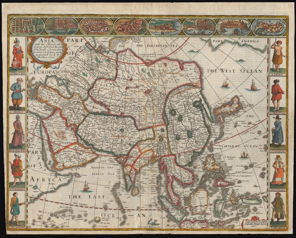
This is John Speed's 1626 map of Asia, the first map of the continent printed in English, in its 1676 edition. This beautiful map is one of the most desirable early maps of continent, combining superb engraving, attractive Dutch styling, and entertaining and abundant English text.
A Closer Look
The map embraces all of Asia, including Japan and the Spice Islands, and a portion of the American northern Pacific coast. The map advertises its source in Hondius (as opposed to Blaeu) by its presentation of Korea as a long peninsula, and by portraying a broad oceanic separation between Asia and America. Speed was an accomplished historian and compiler, drawing his maps from state-of-the-art sources. In this case, the cartography for this map is drawn from the 1623 map of Jodocus Hondius (Speed's engraver, Abraham Goos, was Hondius' student.) With respect to this map, the geography did not significantly advance until the issue of Nicolas Witsen's 1687 map of Tartaria. Speed's use of the Hondius map of 1623 for his model was the best choice he could have made. Speed's map presented to an English audience the state of the art of Dutch mapmaking: the product of a great global rival.Presenting the Idea of Asia
Speed's maps were the only English ones to employ the decorative elements associated with the carte á figures as a form: key city views along the top border, along with figures to the left and right depicting the denizens of the lands. Across the top of the map are city views of the Indian cities of Candy and Goa, Damascus and Jerusalem of the Levant, the Arabian ports of Ormus and Aden, and the Spice Island entrepots of Bantam and Macao. The figures to the left and right portray the denizens of Syria, Arabia, Armenia, Sumatra, Java, China, the Moluccas and a Balagutan (cases have been made for both India and the Philippines for this one.) It is interesting to note that, along with the figure of a 'Tartarian,' a Muscovite woman is shown here (as opposed to appearing on the map of Europe.)The Engraver
Speed's adoption of the Dutch carte á figures map style (and indeed, the entirety of the Dutch state-of-the-art for the mapping of Asia) becomes unsurprising when one considers the degree to which Speed was dependent on Dutch engravers. Virtually all of the maps produced for Speed during his lifetime were executed by Jodocus Hondius and (as is the case here) his protégé and student Abraham Goos: it would appear that, until well into the 17th century, the art of engraving in the British Isles was unequal to the challenge posed by the production of maps. Not until this 1676 Bassett and Chiswell edition of Speed's work would maps be included that were actually executed by an Englishman, Francis Lamb.Publication History and Census
Although Speed died in 1629, his atlas was kept active long afterwards as its plates passed from George Humble to William Garrett to Roger Rea and ultimately to Basset and Chiswell, whose final edition of 1676 is the most easily found. This separate map is listed a handful of times in OCLC in various editions. Basset and Chiswell's Theatre of the Empire of Great-Britain is well represented in institutional collections.CartographerS
John Speed (1542 - 1629) was an important English historian and cartographer active in the early 17th century. Speed was born in Fardon, Cheshire and apprenticed under his father as a tailor. Though his heart was never in tailoring, Speed dedicated himself to this profession until he was about 50 years old. During all the time, Speed dedicated his spare time to research as amateur historian and mapmaker - even preparing several maps for Queen Elizabeth. In London, Speed's interest in history lead him to join the Society of Antiquaries. Eventually he befriended the wealthy Sir Fulke Greville, who sponsored his researches and eventually freed him from the haberdashery profession. Working with William Camden, Speed eventually published his 1611 Historie of Great Britaine. Though this history itself was amateurish and of minimal importance, Speed's inclusion of numerous maps of British Cities and town was seminal. In many cases these plans were the first maps ever issued of their respective subjects. Later, turning his attention more fully to Geography, Speed published the magnificent atlas Theatre of the Empire of Great Britaine and, just prior to his death, the 1627 A Prospect of the Most Famous Parts of the World. These were the first British world atlases and have a landmark position in the history of cartography. These atlases continued to be published well after Speed's death. More by this mapmaker...
Abraham Goos (1590 - 1643) was a Dutch engraver of maps, sea charts, and globes based in Antwerp and Amsterdam. He was born in Haarlem, the sone of diamond cutter Pieter Goos and Margaret van de Keere. Through is mother he was related to engraver Pieter van den Keere (Petrus Kaerius; 1571 - 1646), the brother-in-law of map publisher Jodocus Hondius (1563 - 1612). He was likely trained in engraving by Kaerius, as his first known work is a collaboration on the 1614 terrestrial globe of Petrus Plancius. He went on to engrave for Joannes Jansson, Jocodus Hondius, and John Speed. One of his most significant works is the Holy Land map of Yaacov ben Avraham Aladdin, considered one of the earliest printed maps in Hebrew. Abraham Goos was succeeded by his son Pieter Goos (1616 - 1675), who was in tern succeeded by his son Henrik Goos. Learn More...
Source
Speed, John, The Theatre of the Empire of Great Britaine, (London: Basset and Chiswell) 1676.
Condition
Good. Reinforced printers' creases, margins close with slight trimming in bottom left corner. Few marginal mends. Else very good.
References
OCLC 937874655. Rumsey 12058.171 (1626).