This item has been sold, but you can get on the Waitlist to be notified if another example becomes available, or purchase a digital scan.
1814 Playfair Map of Australia, Indonesia, and Micronesia
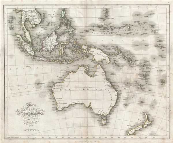
AsiaticIslands-playfair-1814$87.50

Title
The Asiatic Islands.
1814 (dated) 17.5 x 21.5 in (44.45 x 54.61 cm) 1 : 19008000
1814 (dated) 17.5 x 21.5 in (44.45 x 54.61 cm) 1 : 19008000
Description
This is an 1814 James Playfair map of the South Pacific, including Australia, New Zealand, Melanesia, Micronesia, and Indonesia. The map depicts from the Indochinese peninsula, the Philippines, and the Mariana Islands to Australia (New Holland) and New Zealand and from Malaysia and Sumatra to New Caledonia and the New Hebrides. Numerous islands, large and small, are labeled, including Guadalcanal in the Solomon Islands, New Britain and New Ireland, New Guinea, the Caroline Islands, Borneo, Java, and Singapore (Sincapoor). Mindanao, Palawan, and Luzon in the Philippines are also labeled. The exploration of Australia is referenced by several different notations about the expeditions of different adventurers. On the larger islands, myriad cities and towns are labeled. Rivers are depicted and labeled on the Indochinese peninsula, on several of the islands in Indonesia, and on Mindanao.
This map was published by James Playfair in 1814 in his A New General Atlas, Ancient and Modern and printed by Thomas Underwood in London and Hill in Edinburgh.
This map was published by James Playfair in 1814 in his A New General Atlas, Ancient and Modern and printed by Thomas Underwood in London and Hill in Edinburgh.
Cartographer
Dr. James Playfair (1738-1819) was a prominent figure in 18th century Scotland. He was appointed Principal of the United College of St. Salvator and St. Leonard in the University of St. Andrews in 1799 and served in that position until his death in 1819. More by this mapmaker...
Source
Playfair, J., A New General Atlas, Ancient and Modern, (T. Underwood: London and P. Hill: Edinburgh) 1814.
Condition
Very good. Verso repair between Australia and New Caledonia.
References
Rumsey 4462.041. OCLC 223234708.