1874 Tardieu Map of Asia
Asie-tardieu-1874$125.00

Title
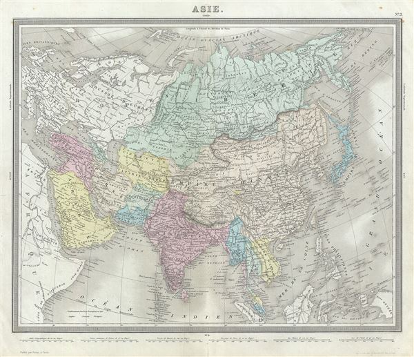
Asie.
1874 (undated) 15 x 18.5 in (38.1 x 46.99 cm) 1 : 29000000
1874 (undated) 15 x 18.5 in (38.1 x 46.99 cm) 1 : 29000000
Description
This is a beautiful 1874 map of Asia by Ambroise Tardieu. It covers from the Arabian Peninsula and Turkey eastward as far as Kamchatka and Japan and includes the Empires of Hindoostan (India), China (includes Tibet), Persia (Iran), Afghanistan, Beloochistan, Birmah (Burma), Japan, Russia, etc. Also included are portions of Europe and the East Indies. Throughout, the map identifies various railroads, cities, towns, rivers, islands, mountain passes and an assortment of additional topographical details. The map is color coded according to regional and political boundaries with elevation rendered by hachure.
Tibet and Korea (Corea) are included within the borders of the Chinese Empire. The disputed body of water between Korea and Japan is here identified as the 'Sea of Japan.' Taiwan or Formosa is mapped vaguely, representing the poor knowledge of the region prior to the Japanese invasion and subsequent survey work in 1895.
As this map was drawn, Imperial China wilted under the weak Qing Dynasty while the Russian Empire attained the height of its pan-continental expansion. Turkey and the Middle East were under Ottoman rule while the British Raj governed of India.
This map was prepared by Ambroise Tardieu and issued as plate 21 in his 1874 edition of Atlas Universel de Geographie Ancienne et Moderne.
CartographerS
Ambroise Tardieu (March 2, 1788 - January 17, 1841) was a prominent French cartographer and engraver operating in the late 18th and early 19th centuries. He was member of the large and prolific Tardieu family, which, for over 200 years, produced multiple skilled and active engravers. Tardieu's work is known for its beauty and accuracy as well as for its depth of detail. Tardieu's most important work is his version of John Arrowsmith's large format map of the United States, published in 1806. Ambroise Tardieu is eclipsed in fame by his son, artist and medical scholar, August Ambroise Tardieu. Ambroise Tardieu is also frequently confused with Jean Baptiste Pierre Tardieu, another unrelated French map and print engraver active in the early 19th century. More by this mapmaker...
Alexandre Aimé Vuillemin (1812 - 1880) was an engraver, publisher, and editor based in Paris, France in the middle of the 19th century. Despite a prolific publishing career, much of Vuillemin's life is shrouded in mystery. In 1852, he married Josephine Caroline Goret and they had at least one child, Ernestine Adèle Vuillemin, later in the same year. What is known is that his studied under the prominent French Auguste Henri Dufour (1798 - 1865). Vuillemin's most important work his detailed, highly decorative large format Atlas Illustre de Geographie Commerciale et Industrielle. Learn More...
Source
Furne, Jouvet et Cie Atlas Universel de Geographie Ancienne et Moderne (Paris), 1874.
Condition
Very good. Minor wear along original centerfold. Original platemark visible. Minor spotting.
References
Rumsey 4697.025 (1863 edition).