Digital Image: 1906 Survey of India Map of East Bengal and Assam, India
AssamBengal-surveyofindia-1906_d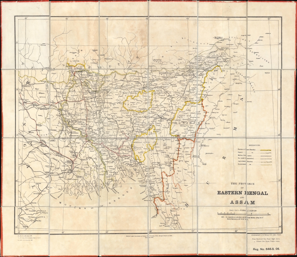

Title
The Province of Eastern Bengal and Assam.
1906 (dated) 22.25 x 25.25 in (56.515 x 64.135 cm) 1 : 2027520
1906 (dated) 22.25 x 25.25 in (56.515 x 64.135 cm) 1 : 2027520
Description
FOR THE ORIGINAL ANTIQUE MAP, WITH HISTORICAL ANALYSIS, CLICK HERE.
Digital Map Information
Geographicus maintains an archive of high-resolution rare map scans. We scan our maps at 300 DPI or higher, with newer images being 600 DPI, (either TIFF or JPEG, depending on when the scan was done) which is most cases in suitable for enlargement and printing.
Delivery
Once you purchase our digital scan service, you will receive a download link via email - usually within seconds. Digital orders are delivered as ZIP files, an industry standard file compression protocol that any computer should be able to unpack. Some of our files are very large, and can take some time to download. Most files are saved into your computer's 'Downloads' folder. All delivery is electronic. No physical product is shipped.
Credit and Scope of Use
You can use your digial image any way you want! Our digital images are unrestricted by copyright and can be used, modified, and published freely. The textual description that accompanies the original antique map is not included in the sale of digital images and remains protected by copyright. That said, we put significant care and effort into scanning and editing these maps, and we’d appreciate a credit when possible. Should you wish to credit us, please use the following credit line:
Courtesy of Geographicus Rare Antique Maps (http://www.geographicus.com).
How Large Can I Print?
In general, at 300 DPI, you should at least be able to double the size of the actual image, more so with our 600 DPI images. So, if the original was 10 x 12 inches, you can print at 20 x 24 inches, without quality loss. If your display requirements can accommodate some loss in image quality, you can make it even larger. That being said, no quality of scan will allow you to blow up at 10 x 12 inch map to wall size without significant quality loss. For more information, it is best consult a printer or reprographics specialist.
Refunds
If the high resolution image you ordered is unavailable, we will fully refund your purchase. Otherwise, digital images scans are a service, not a tangible product, and cannot be returned or refunded once the download link is used.
Cartographer S
Survey of India (1767 - Present) is India's central engineering agency in charge of mapping and surveying the country. It was founded in 1767 by Major James Rennell, who took the post of first Surveyor General, with the mission to map and consolidate the territories of the British East India Company. The Survey undertook the Great Trigonometrical Survey between 1802 and 1852 in an attempt to accurately measure the Indian Subcontinent - considered one of the greatest feats of mapping of all time. It also sponsored clandestine surveys, at times disguised as Buddhist pilgrims, to infiltrate and map Tibet, then a closed country. With India's independence in 1947, the Survey was folded into the new Indian government, which it remains part of to this day. More by this mapmaker...
Francis Bacon Longe (October 31, 1856 - June 2, 1922) was a British surveyor, cartographer, and military officer. He attended Cheltenham College before entering the Royal Military Academy Woolwich at the end of 1873. He received his commission in 1876 and joined the Royal Engineers and volunteered for service in India. After arriving in India in January 1879, he received orders to Jellalabad, Afghanistan, and was soon assigned the the 7th Company, Bengal Sappers and Miners. His unit fought in the Second Anglo-Afghan War and Longe was among the first troops to enter Kabul. He was appointed to the Survey of India in 1880, and surveyed around Kabul and Kandahar in 1880 and 1881. He worked in Mysore and the United Provinces from 1881 until 1885, when he was appointed Personal Assistant to the Surveyor-General and sent to Calcutta. He served as Survey Officer on several survey missions, including the 1894 Chin-Manipur Commission. He was appointed Assitant Surveyor-General in 1896 and served as Survey Officer for the 1897-1898 Burma-China Boundary Commission. He was appointed Deputy Surveyor-General in 1900. He served as Surveyor-General of India from 1904 through 1911 when he held the rank of lieutenant colonel. He died in London in 1922. While in India he fell in love with May Ethel Marion Calliope, an English woman that had been born in Bengal who was already married with two sons. She divorced her first husband (a Mr. Sankey) and she and Longe married almost immediately after it was final on March 31, 1905. Their marriage did not produce any more children. Learn More...
References
OCLC 48597537, 557222892.