1882 Jules Sédille / Compagnie Générale Transatlantique Map of the Atlantic and United States
Atlantic-sedille-1882$1,650.00

Title
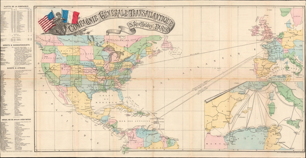
Compagnie Générale Transatlantique.
1882 (dated) 15 x 31.25 in (38.1 x 79.375 cm) 1 : 18000000
1882 (dated) 15 x 31.25 in (38.1 x 79.375 cm) 1 : 18000000
Description
This is an 1882 Jules Sédille map highlighting the transatlantic routes between France and the Americas, primarily issued to promote the Compagnie Générale Transatlantique's service between Le Havre and New York, as well as the routes to the Caribbean and Mexico.
A Closer Look
The map was published as a pamphlet enumerating the details of the routes. The early 1880s saw the company's construction of new, modern ships to service the Atlantic routes. La Normandie was tasked with the Le Havre - New York route shown on the map. Although it also shows the southern routes handled by the company's older ships, the emphasis here is on the routes to the United States. All of the continental U. S. is shown, marking in particular the explosion of railroads across the continent, linking to the transatlantic route at New York. A beautifully executed cartouche in the upper left provides the company name and the address of its Paris office; it is embellished with a design of an anchor and the crossed flags of the United States and France.Mediterranean Routes
An inset map in the lower right details the company's routes in the Mediterranean Sea, linking Marseille with ports in Italy, Spain, and Tunisia - but predominantly with the ports and railroads of French Colonial Algeria, particularly the hubs of Algiers and Oran.Compagnie Générale Transatlantique
The Compagnie Générale Transatlantique (CGT) was a long-lived French transportation company. Founded in 1855 by French railroad industrialists Émile and Isaac Péreire under the name Compagnie Générale Maritime. Its initial growth centered around contracts with the French government to transport mail across the Atlantic; the company changed its name to reflect this in 1861. CGT flourished in the first half of the 20th century. After a period of recovery following World War II (1939 - 1945), it saw a renaissance in the 1960s despite the unavoidable competition of air travel.Publication History and Census
This map was created by Jules Sédille and produced on behalf of the Compagnie Générale Transatlantique by the publisher Mouillot. We see no examples preserved in OCLC and see no examples cataloged or on the market.Cartographer
Jules Sédille (fl. 1861-1890) was a French engraver and printer active in Paris in the latter 19th century. He produced a number of maps over this period for the publishers Chaix, Delagrave, Pariente, and Mouillot; among his works were the maps included in Jules Verne's 1868 Géographie illustrée. More by this mapmaker...
Condition
Very good. Margins close as issued. Wear with very slight loss at junctures of folds. Reinforced with archival tissue.