This item has been sold, but you can get on the Waitlist to be notified if another example becomes available, or purchase a digital scan.

1855 Hobbs Two Sheet Nautical Chart or Maritime of the Atlantic Ocean

AtlanticOcean-hobbs-1855
$1,400.00
A Chart of the Atlantic or Western Ocean. - Main View
Processing...

1855 Hobbs Two Sheet Nautical Chart or Maritime of the Atlantic Ocean

AtlanticOcean-hobbs-1855

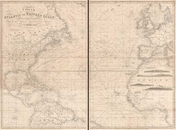
Depicts the Gulf Stream - a current along the coast of North America that effects the climate in the eastern United States and Europe.

Title


A Chart of the Atlantic or Western Ocean.
  1855 (dated).     39 x 26.5 in (99.06 x 67.31 cm)     1 : 7610000

Description


This is an exquisitely composed 1855 John Stratton Hobbs nautical chart or maritime map of the Atlantic Ocean. The map, comprising two sheets, depicts the region from central North America and the Galápagos Islands to Sweden, the Baltic Sea, Sicily, and central Africa and from Hudson's Strait, southern Greenland, the Shetland Islands, and Scandinavia to the Galápagos Islands, the mouth of the Amazon River, and the mouth of the Congo River. A highlight of this chart is the illustration of the Gulf Stream along the coast of North America from the Bahamas to the North Atlantic, an ocean current that has a direct effect on climate in both the Europe and the East Coast of the United States. An incredibly detailed chart, myriad depth soundings (measured in fathoms) populate the coastlines of North, Central, and South America, Europe, and Africa, along with the islands of the West Indies, the Canary Islands, the Cape Verde Islands, and the Azores. The soundings are perhaps the densest in the English Channel and St. George's Channel. Coastal locations throughout both sheets are labeled, along with state capitals in the United States and cities and capitals in all the countries of Europe. Several cities are also labeled in Africa, such as Fez, Tangiers, Algiers, Tunis, and Timbuktu. Rivers and lakes in all illustrated regions are also depicted, including the Missouri and Mississippi Rivers and the Great Lakes in North America, the Amazon in South America, the Congo and the Niger Rivers in Africa, and the Loire, Seine, Rhine, Danube, and Elbe Rivers in Europe. Four profile views of islands are included in the vast empty expanse of inland Africa, illustrated Madeira, Corvo and Flores, Palma, and Tenerife, all of which are part of one European country or another.

This chart was originally compiled by John Stratton Hobbs and published by Charles Wilson in 1855.

CartographerS


John Stratton Hobbs (January 1, 1813 - December 19, 1874) was a British engraver, hydrographer, chart maker, and blueback publisher active in England in the mid-19th century. Hobbs was born in London, the son of William Henry Hobbs, a ship broker of Globe Street, St. George in the East. Much of his work is associated with the firms of John William Norie (1774 - 1843) and Charles Wilson (1807 - 1882). Hobbs compiled charts and engraved for Norie until his death in 1843, when he became head of the hydrographic department of the successor firm, Noire and Wilson. He was elected to the Royal Geographical Society 9 November 1846. More by this mapmaker...


Charles Wilson (1807 - May 16, 1882) was a British-Indian publisher of nautical charts and maps based in London, England. Born in Lucknow, India, Wilson was the son Lieutenant-Colonel William Wilson and his wife Hoosainee Begum, an Indian princess, who was the daughter of the Nizam of Ashrafabad. Wilson was educated in England and worked in the wine trade before joining the Norie firm in 1838. Norie had already partnered with another Wilson, George, who was a nephew to Charles. When Norie retired in 1840, Charles Wilson took over the firm publishing as 'Charles Wilson (Late J.W. Noire and Wilson)'. He married Jane Arabella Bingle on July 1, 1846. Wilson died in 1882 passing the firm on to his sons, George and William Wilson. The brothers merged the firm with that of J. Imray and Sons in 1899 and, as Imray, Laurie, Norie and Wilson Ltd., they continue to publish to the present day. Learn More...

Condition


Very good. Two sheets. Light soiling. Verso repairs of fold separations and minor edge tears. Blank on verso.

References


OCLC 556434602.