This item has been sold, but you can get on the Waitlist to be notified if another example becomes available, or purchase a digital scan.

1884 Upton and Co. Folding Map of Auckland, New Zealand

AucklandNZ-uptonandco-1884
$1,200.00
Upton and Co.'s New Map of the City and Suburbs of Auckland. - Main View
Processing...

1884 Upton and Co. Folding Map of Auckland, New Zealand

AucklandNZ-uptonandco-1884

Rare, Early Cadastral Map of New Zealand's Largest City, w/ Manuscript Annotations.
$1,200.00

Title


Upton and Co.'s New Map of the City and Suburbs of Auckland.
  1884 (undated)     22 x 34.5 in (55.88 x 87.63 cm)     1 : 7920

Description


This is Upton's scarce 1884 folding city plan and cadastral map of Auckland, New Zealand, printed by Wilson and Horton. It provides a fascinating glimpse into the early history and evolution of the fast-growing port city.
A Closer Look
The city of Auckland is displayed divided into wards (the westernmost part of Ponsonby appearing in an inset at top-left), which are color-shaded, with suburbs traced in outline color for easy distinction. The large Domain (also known by its Māori name Pukekawa) towards right was, and remains, the city's largest park. Both city wards and suburbs have subdivisions marked in individual lots, the larger of which have their dimensions recorded. Several important buildings and features are labeled, such as the Government House and parks, while others are noted with a letter corresponding to an index at top-right. Streets are also labeled, as are rail lines and stations, docks, and piers. Several manuscript annotations appear, including a scale at top-right, a ghosted-in street in Eden Terrace, and the red-shading of several lots.
Evolving City Plan
When this map was prepared, Auckland was growing at a rapid clip, having emerged as New Zealand's main port and point of debarkation for immigrants. Due to fears of Māori resistance, the British also encouraged and incentivized recently discharged soldiers to settle in the city, leaving it with an unusually high proportion of ex-soldiers, and, for the same reason, Irish-born settlers. Resource-extractive industries around Auckland, such as logging and gold mining, also contributed to its quick pace of growth.

This map reflects both the state of the city at the time and planned future expansion. The suburbs and even some of the wards (especially Grafton and Ponsonby) were still in the process of being surveyed and subdivided; thus, their modern street plans often differ from that seen here.
Publication History and Census
This folding map was prepared by Upton and Co., the head of which would go on to be Mayor of Auckland a handful of years later (see biography below), and was printed by Wilson and Horton. An attached label gives the date of 1884. Other known examples of the map from this era include those held by the National Library of New Zealand, University of Otago, and Auckland Museum, which are dated 1885 or 1886. Maps with this title or a similar titles, also quite rare, were prepared by Upton and Co. for several years afterward, well into the early 20th century, but differ considerably in presentation and in the information contained (see a digitized example from 1900 held by the Auckland Council Libraries, cataloged as Map 6618).

CartographerS


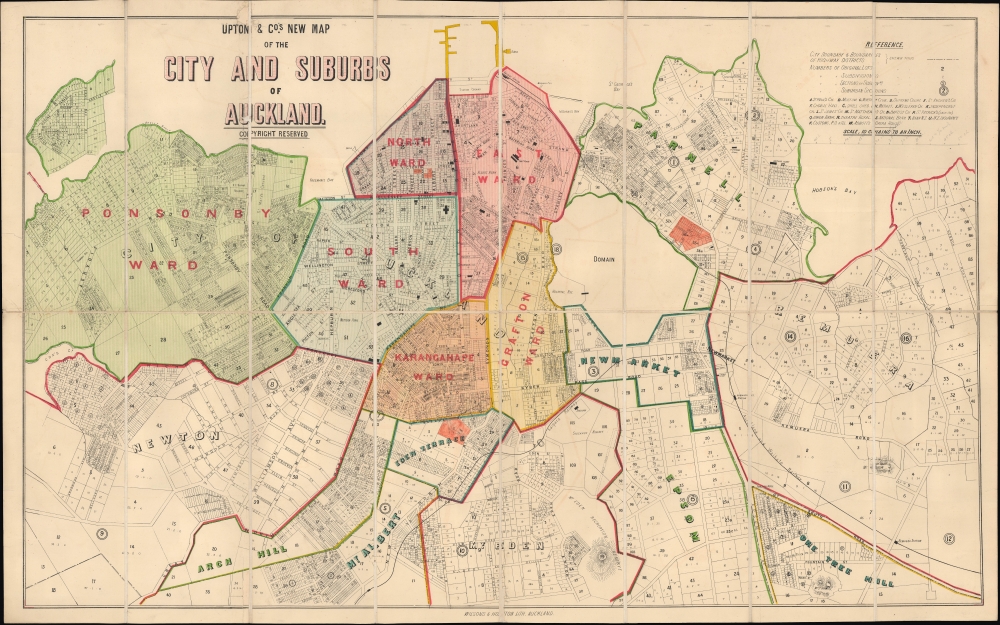
Upton and Company (1864 - 1914) was a bookseller, stationer, and publisher based in Auckland, New Zealand. The company was founded by William Brown Upton (1840 - 1870), a native of Lincolnshire, England who emigrated to New Zealand in 1858, setting up a bookseller shop in 1864. His brother John Henry Upton (1845 - 1929) arrived in Auckland two years later and became his business partner (going by several names, including Upton, Upton Brothers, W. B. and J. H. Upton, and Upton and Co.), which allowed the business to continue after William's untimely death from illness at age 29. Afterwards, the younger Upton managed the business with his brother-in-law William Gorrie (1840 - 1911). John Henry Upton was a busy man who took on many business and civic roles - including director of several companies, chairman of directors of the Bank of New Zealand, and Mayor of Auckland (1890 - 1891) - presumably leaving Gorrie to handle much of the publishing and bookselling. Upton's sons Parker Tasker (1877 - 1955) and Selwyn (1878 - 1922) also became involved in the business and took over management of it in 1909. But the company ran into financial difficulties and was sold to Whitcombe and Tombs (later Whitcoulls) in 1916. More by this mapmaker...


Wilson and Horton (1876 - 2002) was an Auckland, New Zealand-based printer, publisher, and media company, best known for publishing the New Zealand Herald and Auckland Weekly News. The company functioned as a remarkable multigenerational partnership between two families from 1876, when brothers William Scott Wilson and Joseph Liston Wilson (whose father William Chisholm Wilson had founded the New Zealand Herald in 1863) and Alfred George Horton. While newspapers remained their mainstay, the firm also published books and occasionally maps and other media, mostly relating to New Zealand. The company went through several rounds of restructuring in the late 20th century, with the Irish Independent News and Media Group purchasing the Horton portion of the business in 1996, though the name Wilson and Horton continued to be used until 2002. Later, the Australian APN News and Media purchased the New Zealand Herald, continuing to publish a print version down to the present but increasingly focusing on the newspaper's online edition. Learn More...

Condition


Very good. Dissected and mounted on linen. Small area of infill along top border above title.

References


OCLC 949676364.