This item has been sold, but you can get on the Waitlist to be notified if another example becomes available, or purchase a digital scan.
1726 Valentijn Map of Ayutthaya, Siam, Thailand
Ayutthaya-valentijn-1726$325.00

Title
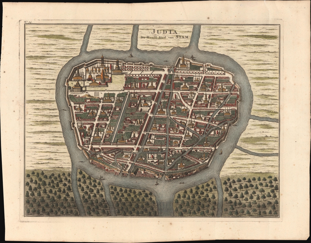
Judia, de Hoofd-Stad van Siam.
1726 (dated) 11.5 x 15 in (29.21 x 38.1 cm)
1726 (dated) 11.5 x 15 in (29.21 x 38.1 cm)
Description
This is a striking 1726 Francois Valentijn view and map of Ayutthaya, capital of Siam (Thailand), under the aptly named Ayutthaya Kingdom (1351 - 1767), considered a golden age for Thailand. The map illustrates the city at its peak when it was one of the world's largest and wealthiest. At this time, few Europeans had contact with Ayutthaya, as the French and other Europeans were banned from the Kingdom in 1688, leaving only the Dutch with a tenuous presence.
A Closer Look
The map is oriented to the north, with Ayutthaya situated on an island on the Menam (Chao Phraya) River. The city is bisected by a Grand Canal, connecting to subsidiary canals in the eastern and southern districts. Impressive defensive walls surround it, reflecting security concerns in the face of ongoing wars with neighboring Burma. The whole appears to be densely forested, with large areas of greenery between Buddhist temples, monasteries, palaces, and residential structures. Thai-style stupas are represented accurately, suggesting that although this map names no streets, buildings, or canals, it is a faithful presentation of Ayutthaya at its height and just decades before its fall.Ayutthaya: Capital of Siam
In the early 1700s, Ayutthaya was the capital of the Kingdom of Siam (Thailand) and a hub of trade, diplomacy, and culture. By this time, the city had established itself as one of the largest, wealthiest, and most cosmopolitan in the world, attracting merchants and diplomats from across Asia, Europe, and the Middle East. Ayutthaya's prosperity was not to last. In 1767, after years of conflict with neighboring Burma, the Burmese forces invaded and completely destroyed Ayutthaya, marking the end of the Ayutthaya Period. The city was left in ruins, its palaces and temples burned and looted, and its people displaced. This catastrophic event led to a period of instability until King Taksin established a new Siamese capital in Bangkok later that same century. Ayutthaya's fall marked a significant shift in the history of Siam, though the ruins of the city stand today as a reminder of its former grandeur.The VOC and the East Indies
Francois Valentijn (1666 - 1727), a missionary, printer, and author, was among the first to publish on the history and management of the VOC in the East Indies. Cartographic knowledge of the East Indies was tightly controlled by the VOC throughout the 17th century. Valuable cartographic data was typically shared among VOC pilots in manuscript form and rarely ever submitted to printing. Valentijn spent 16 years in the East Indies as a VOC minister and, as such, doubtless had access to secret charts, such as the Vingboons Atlas. Despite the strict VOC injunction on publishing its valuable maps, Valentijn successfully published his work in 1726. In the same year, Johannes van Keulen II was commissioned as the official VOC hydrographer and published his own 'secret atlas' of VOC maps. The fact that both were published in 1726 suggests that the era of VOC dominance in the East Indies had nearly come to an end.Publication History and Census
This map was published in 1726 to illustrate Valentijn's Oud en Nieuw Oost-Indien. We see just three examples in OCLC, at the British Library, the Bibliothèque nationale de France, and Harvard.Cartographer
Francois Valentijn (April 17, 1666 - August 6, 1727) was a Dutch minister, naturalist, colonial administrator, and historian active in Holland and the East Indies, in the late 17th and early 18th centuries. Valentijn was born in Dordrecht, Holland and studied at the Universities and Leiden and Utrecht before, in 1685, taking a position with the Dutch East India Company (VOC). He remained in the East Indies for about 10 years before returning to Dordrecht. Unable to adjust to life in Europe, he returned to the East Indies in 1705 where he remained for another 9 years. After 19 total years in the Orient working for the VOC, Valentijn once again returned to Holland where he composed his eight volume five part masterwork Oud en Nieuw Oost-Indien. The scope and detail of this work, including over 1000 engraved images and numerous maps was unprecedented with regards to Asia. The work contained some of the finest and most detailed large scale maps of the East Indies ever published. The most important of these focus on Taiwan and Malaya. Valentijn most likely drew on secret VOC manuscript maps and documents, a fact that makes it exceptionally surprising that his works were actually published. Valentijn academic scholarship, in sharp contrast to his cartographic work, is often highly criticized as being self-aggrandizing and, more often than not, plagiarized. More by this mapmaker...
Source
Valentijn, F., Oud en Nieuw Oost-Indien, (Dordrecht: J. van Braam) 1726.
Condition
Very good.
References
OCLC 1252280426, 498402078, 495019048.