1649 Joan Blaeu view and plan of Bailleul (Nord, France)
Bailleul-blaeu-1649$350.00

Title
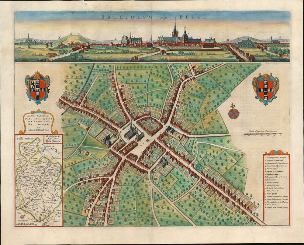
Balliolum vulgo Belle.
1649 (undated) 16.5 x 20.75 in (41.91 x 52.705 cm) 1 : 3400
1649 (undated) 16.5 x 20.75 in (41.91 x 52.705 cm) 1 : 3400
Description
This is Joan Blaeu's 1649 bird's-eye plan and panorama, of Bailleul, France. This city, now in the Département Nord, was then part of the Netherlands; consequently, it was one of the cities featured in Blaeu's rare atlas of the cities of the Netherlands.
The 20th century was cruel to Flanders: Bailleul was close to the brutal fighting of Ypres, even being reached by the German chlorine gas released on April 30, 1916. The German spring offensive of April 1918 destroyed 90% of the city and the town center depicted here. The town was rebuilt in the Flemish style during the 20th century.
A Closer Look
The panorama at the top presents Bailleul as seen from the south: the orientation is the same as the map below it. Its religious buildings dominate the skyline, particularly the Saint-Vaast Church at the town's center. These structures are identified both on the view and the plan using numbers keyed to a legend in the lower right. The civic arms are presented in the map's top left and right corners. In the lower left is an inset map of the castellany of Belle-Ambach, then a subdivision of Flanders and now part of the Département Nord. The inset, oriented to the northwest, spans from Armentiers to the region around Cassel.A Borderland and Battleground
Bailleul and Belle-Ambacht, along with the rest of Flanders, passed to the Spanish Netherlands from France in the 1526 Treaty of Madrid. Over the course of the Eighty Years’ War (1568 - 1648), Flanders became a constant battleground; ultimately, the 1648 Treaty of Münster assigned Belle-Ambacht to the Spanish Netherlands. Not long after, France under Louis XIV reconquered Flanders, resulting in Bailleul's 1678 return to France.The 20th century was cruel to Flanders: Bailleul was close to the brutal fighting of Ypres, even being reached by the German chlorine gas released on April 30, 1916. The German spring offensive of April 1918 destroyed 90% of the city and the town center depicted here. The town was rebuilt in the Flemish style during the 20th century.
Publication History and Census
Probably surveyed, drawn, and engraved by Vedastus du Plovich, this plate was published in 1649 in Joan Blaeu's Novum ac magnum theatrum urbium Belgicae Regiae. It is scarce. Only four separate examples are cataloged in institutional collections. The present example's Dutch verso text identifies it as originating in the first edition of the city book.CartographerS
Joan (Johannes) Blaeu (September 23, 1596 - December 21, 1673) was a Dutch cartographer active in the 17th century. Joan was the son of Willem Janszoon Blaeu, founder of the Blaeu firm. Like his father Willem, Johannes was born in Alkmaar, North Holland. He studied Law, attaining a doctorate, before moving to Amsterdam to join the family mapmaking business. In 1633, Willem arranged for Johannes to take over Hessel Gerritsz's position as the official chartmaker of the Dutch East India Company, although little is known of his work for that organization, which was by contract and oath secretive. What is known is his work supplying the fabulously wealthy VOC with charts was exceedingly profitable. Where other cartographers often fell into financial ruin, the Blaeu firm thrived. It was most likely those profits that allowed the firm to publish the Theatrum Orbis Terrarum, sive, Atlas Novus, their most significant and best-known publication. When Willem Blaeu died in 1638, Johannes, along with his brother Cornelius Blaeu (1616 - 1648) took over the management of the Blaeu firm. In 1662, Joan and Cornelius produced a vastly expanded and updated work, the Atlas Maior, whose handful of editions ranged from 9 to an astonishing 12 volumes. Under the brothers' capable management, the firm continued to prosper until the 1672 Great Amsterdam Fire destroyed their offices and most of their printing plates. Johannes Blaeu, witnessing the destruction of his life's work, died in despondence the following year. He is buried in the Dutch Reformist cemetery of Westerkerk. Johannes Blaeu was survived by his son, also Johannes but commonly called Joan II, who inherited the family's VOC contract, for whom he compiled maps until 1712. More by this mapmaker...
Vedastus du Plovich (fl. 1641-1660) was a Dutch mathematician, engraver and cartographer, most notably employed in producing city plans and views. Initially he had produced many of such for Antonius Sanderus' Flandria Illustrata, which was to be published by Henry Hondius. That mapseller sold the project to Joan Blaeu, who brought it to completion in his 1649 city book of the low countries, Novum Ac Magnum Theatrum Urbium Belgicae Foederatae. Learn More...
Source
Blaeu, J., Novum Ac Magnum Theatrum Urbium Belgicae Foederatae, (Amsterdam: Blaeu) 1649.
Condition
Good. Tears entering image at top, impacting only border and titles, expertly mended. Else a beautifully colored example with a bold, sharp image.
References
OCLC 494994938. Koeman, Atlantes Neerlandici, vol. 1, p. 328, Bl 69A. Shirley, R. Maps in the Atlases of the British Library: A Descriptive Catalogue c. AD 850-1800, p. 244, T. BLA-3a.