This copy is copyright protected.
Copyright © 2025 Geographicus Rare Antique Maps
Digital Image: 1858 Lange Map of the Southwestern United States
BalduinMullhausenReise-lange-1858_d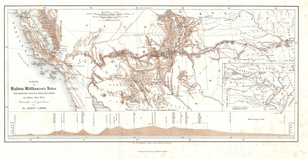

FOR THE ORIGINAL ANTIQUE MAP, WITH HISTORICAL ANALYSIS, CLICK HERE.
Digital Map Information
Geographicus maintains an archive of high-resolution rare map scans. We scan our maps at 300 DPI or higher, with newer images being 600 DPI, (either TIFF or JPEG, depending on when the scan was done) which is most cases in suitable for enlargement and printing.
Delivery
Once you purchase our digital scan service, you will receive a download link via email - usually within seconds. Digital orders are delivered as ZIP files, an industry standard file compression protocol that any computer should be able to unpack. Some of our files are very large, and can take some time to download. Most files are saved into your computer's 'Downloads' folder. All delivery is electronic. No physical product is shipped.
Credit and Scope of Use
You can use your digial image any way you want! Our digital images are unrestricted by copyright and can be used, modified, and published freely. The textual description that accompanies the original antique map is not included in the sale of digital images and remains protected by copyright. That said, we put significant care and effort into scanning and editing these maps, and we’d appreciate a credit when possible. Should you wish to credit us, please use the following credit line:
Courtesy of Geographicus Rare Antique Maps (http://www.geographicus.com).
How Large Can I Print?
In general, at 300 DPI, you should at least be able to double the size of the actual image, more so with our 600 DPI images. So, if the original was 10 x 12 inches, you can print at 20 x 24 inches, without quality loss. If your display requirements can accommodate some loss in image quality, you can make it even larger. That being said, no quality of scan will allow you to blow up at 10 x 12 inch map to wall size without significant quality loss. For more information, it is best consult a printer or reprographics specialist.
Refunds
If the high resolution image you ordered is unavailable, we will fully refund your purchase. Otherwise, digital images scans are a service, not a tangible product, and cannot be returned or refunded once the download link is used.
Henry Lange (April 13, 1821 - August 30, 1893) was a German writer and cartographer. Born in Stettin, Lange attended Heinrich Berghaus's cartography school in Potsdam. For three years, beginning in 1844, Lange worked on Scottish geographer Alexander Keith Johnston's (1804 - 1871) first Physical Atlas. He returned to Germany in 1847 and worked as a freelance cartographer in Berlin. During this time he produced maps for researchers and publishers in Berling, including Alexander von Humboldt, Heinrich Kiepert, Heinrich Barth, and Carl Ritter. Lange set up the cartographic department for FA Brockhaus, a publishing house in Leipzig, between 1855 and 1859, after which he returned to creating commissioned works. He earned a position wit the Royal Statistical Office in 1868, a position he held until he retired in 1891. Lange played an instrumental role in founding the Central Association for Commercial Cartography and the promotion of German interests abroad. During the course of his career, Lange produced hand and travel atlases, Bible atlases, and works of industrial and commercial geography. He is most often remembered for his works of school cartography, which were published by George Westermann (1810 - 1879). Among these were the Neuesten Schulatlas sum Unterrichte in der Erdkunde, for which he made revisions for ninety editions until 1892. Another of his extremely successful school atlases Neue Volkschulatlas über all Teile Der Erde had over 230 editions and printed over 2.4 million printed copies from 1871 until Lange's death. More by this mapmaker...
Copyright © 2025 Geographicus Rare Antique Maps | Geographicus Rare Antique Maps
This copy is copyright protected.
Copyright © 2025 Geographicus Rare Antique Maps