1990 Sharon Riley Pictorial Map of Bar Harbor, Mount Desert Island, Maine
BarHarbor-riley-1990$250.00

Title
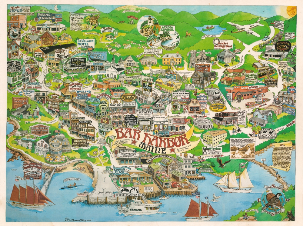
Bar Harbor Maine.
1990 (dated) 17.75 x 23.75 in (45.085 x 60.325 cm)
1990 (dated) 17.75 x 23.75 in (45.085 x 60.325 cm)
Description
This is a 1990 Sharon Lee pictorial view and map of Bar Harbor, Mount Desert Island, Maine. For most visitors to Mount Desert Island, Bar Harbor is the Gateway to Acadia National Park - the only major national park in New England.
A Closer Look
The view looks southward on Bar Harbor, with the town pier in the foreground and Cadillac Mountain rising on the horizon. It highlights iconic Bar Harbor businesses as of 1990 - although many remain active. The map also features historical annotation and illustrations of local life and attractions: Door Mountain, Cadillac Mountain, Eagle Lake, The Bar, etc.Acadia National Park
Mount Desert Island, so named because of its many bald rocky mountaintops, has been a tourist destination since the mid-19th century, when it was discovered by outsiders, artists, journalists, Hudson River School artists, and other patrons, known collectively as the 'Rusticators.' Undaunted by crude accommodations and simple food, they sought out local fishermen and farmers for accommodation and guidance. Summer after summer, the Rusticators returned to renew friendships with local islanders and, most of all, to savor the fresh salt air, scenery, and relaxed pace. Soon the villagers' cottages and fishermen's huts filled to overflowing, and by 1880, 30 hotels competed for vacationers' dollars. Tourism was becoming the island's primary industry. Drawing the attention of the wealthy and influential, the island was designated as Sieur de Monts National Monument by President Woodrow Wilson in July 1916. In February 1919, the area's status was officially changed from a National Monument to a National Park, making it the first National Park east of the Mississippi River. With the change to a National Park came a name change as well, to Lafayette National Park. It was not until January 1929 that the park was given its current name, Acadia National Park. Acadia is unlike most other National Parks, as its creation was encouraged by numerous private individuals. One, John. D. Rockefeller, purchased a summer home in Bass Harbor in 1910. Rockefeller began buying up land on the island with the goal of creating a system of carriage roads to make 'one of the greatest views in the world' accessible to all visitors.Publication History and Census
This view was drawn and published in 1990 by Sharon Riley. The map is scarce on the market with no examples noted in OCLC.Cartographer
Sharon Lee Riley (December 12, 1950 - January 12, 2020) was a Bar Harbor, Maine, based painter and sculptor. She was employed for many years at Arnold's Video, a Bar Harbor staple that went out of business in 2015. She was also active in the community, contributing her artistic talent to local events, parades, etc. In 1990, she issued a pictorial map of Bar Harbor celebrating and advertising its stable businesses - including Arnold's. More by this mapmaker...
Condition
Good. Slight edge wear. Minor discoloration lower left corner.