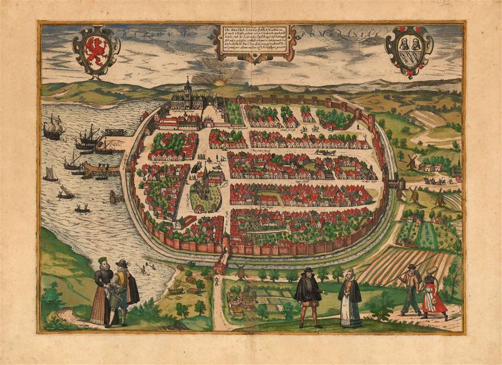
1593 Braun and Hogenberg View of Barth, Germany
Barth-braunhogenberg-1593
Title
1593 (undated) 12.75 x 17.5 in (32.385 x 44.45 cm)
Description
A Closer Look
The engraving presents the walled and moated city (the center of the modern city) as seen from the west (signaled by a brilliant sunrise on the horizon). The Barther Bodden, a lagoon on the Baltic coast, is to the left, with fishing boats and sailing ships at the city's docks. The western gate, leading to the Dammstrasse, is protected by a tower (the Dammtor) which survives to this day and is easily recognizable. The Langstrasse, Fischerstrasse, and Hunnenstrasse, are named on the map and are recognizable in the modern city. The gothic St. Marien Kirche and its cemetery can be seen near the center. The waterfront - actually beyond the moat, facing the Barther Bodden to the north - corresponds to the modern Hafenstrasse. This is no longer the waterfront, which has been expanded with landfill to create today's harbor.The surrounds of the city are depicted as rolling hills and farmland, interspersed with villages and windmills. In the foreground are three couples - Pomeranian nobles, merchants, and farmer-folk, in their customary garb. People can be seen walking, riding, and working in the distance. In the upper left are the arms of Pomerania; to the upper right are the arms of the city of Barth.
Barth was a medieval city, and remained small compared with its neighbors. It was never a Hanseatic town, and its growth was hampered by all-too-frequent wars and plague. In 1572, however, the Duke of Pomerania Bogislaw XIII rebuilt the Ducal court (Dass Furstlichhaus in the view) and invested in the town, thinking to make it the port for his new city of Franzburg. The resulting vibrant, flourishing city is captured here - prior to the depredations of the Black Death in 1597 and 1598.
Publication History and Census
This was among the views added to the fifth book of Braun and Hogenberg's Civitates Orbis Terrarium, first printed in 1593. It is therefore one of their scarcer works, as there were few editions to follow. We see only four separate examples in institutional collections. We see records of a handful of examples appearing on the market over the past forty years, but the view does appear on the market from time to time.CartographerS
Georg Braun (1541 – March 10, 1622) was a German deacon, viewmaker, and typo-geographer based in Cologne. Along with Franz Hogenberg (1535 - 1590), Braun is best known for his publication of the highly influential city atlas Civitates Orbis Terrarum. The six volume work, with some 546 views, was published between 1572 and 1617 and intended a companion to Abraham Ortelius' Theatrum Orbis Terrarum - thus certain obvious stylistic similarities. In compiling the Civitates Braun took on the role of editor while most of the engraving work was completed by Franz Hogenberg. Braun died, as he was born, in Cologne. More by this mapmaker...
Franz Hogenberg (1535 - 1590), often called 'Master Franz,' was a Flemish engraver active in the late 16th century. Hogenberg was born in Mechelen, the son of Nicolas Hogenberg, where he trained under the cartographer H. Terbruggen. He later relocated to Antwerp where he achieved success as an engraver, working with Abraham Ortelius, Hieronymus Cock, and others. In 1568, his name appeared on the list of those banned from the Netherlands by the Duke of Alva, forcing his family to flee to London. There he engraved for Christopher Saxon's Atlas of England and Wales. By 1570 he emigrated to Germany settling in Cologne. In Cologne he married his second wife, Agnes Lomar, with whom he had six children. In 1579 the couple were briefly imprisoned for holding illicit secret religious meetings, but were released in short order. Along with German cleric George Braun (1541 – March 10, 1622), Hogenberg issued the highly influential city atlas Civitates Orbis Terrarum. The six volume work, with some 546 views, was published between 1572 and 1617 and intended a companion to Abraham Ortelius' Thatrum Orbis Terrarum - thus certain obvious stylistic similarities. In compiling the Civitates Hogenberg took on the role of engraver while most of the editing was left to Georg Braun. Hogenberg died in Cologne, Germany, before the Civitates was completed. After his death, Hogenberg's work was continued by his son, Abraham Hogenberg, who, under the direction of Agnes, his mother, took over his father's enterprise at just 20. Learn More...

