1925 Kennard Thomson Manuscript Map of Tidal Barrages on the Bay of Fundy
BayOfFundy-kennardthomson-1925$1,200.00

Title
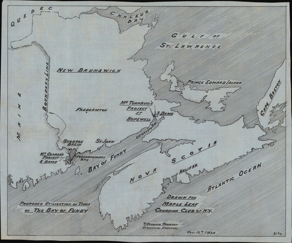
Proposed Utilization of Tides of the Bay of Fundy.
1925 (dated) 18.25 x 22 in (46.355 x 55.88 cm) 1 : 3040000
1925 (dated) 18.25 x 22 in (46.355 x 55.88 cm) 1 : 3040000
Description
A unique historical survival, this 1925 manuscript planning map of proposed tidal barrages on the Bay of Fundy was drawn by American engineer Thomas Kennard Thomson for the Maple Leaf Canadian Club of New York.
Thomas Kennard Thomson, who drew this map, was an American civil engineer with a penchant for ambitious projects (see other maps of his listed by us, including a proposal to replace New York City's subways with multitiered elevated roadways and to create badly-needed land in the city by filling in the East River). Though the projects outlined here were not his own, Thomson expressed interest in them but ultimately deemed them too expensive to warrant construction.
Although funds were committed to both Cooper and Turnbull's projects by their respective governments for surveying and preparatory work, the former gained significantly more traction, in large part due to the political support of Franklin Delano Roosevelt, who owned a summer home on nearby Campobello Island (helpfully, he was a neighbor of Cooper's mother-in-law). Nonetheless, private financing was never sufficient to begin work on the project. When Roosevelt became president, he continued to champion the idea of tidal dams at Passamaquoddy Bay despite skepticism from government officials and engineers that such a project would be cost-effective.
In 1935, Roosevelt allocated $7 million from the Public Works Administration budget for the Passamaquoddy Bay Tidal Power Project. Construction began on July 4 that year in Eastport and Lubec, Maine, with the Army Corps of Engineers building a complete town for the thousands of workers expected to work on the dams. Bulldozers and dynamite began moving earth in preparation for building the dams. However, opposition in Congress, where many saw the project (with some justification) as a boondoggle, soon led to its funding being cut off. The workers' housing was repurposed by the Navy as a training facility during the Second World War, but otherwise, nothing else remained of the Passamaquoddy Bay Tidal Power Project. In the years since, other engineers have continued to imagine that tidal power stations could be established at Passamaquoddy and Chignecto Bays but have had trouble finding a construction method that would justify the costs against the marginal benefits provided to such sparsely inhabited areas, especially given the lower cost of alternative means of power generation.
A Closer Look
The map highlights the Bay of Fundy between Nova Scotia and New Brunswick, displaying two proposed dam projects, one consisting of five dams on the border of Maine and New Brunswick at Passamaquoddy Bay and another composed of three dams at Hopewell Cape on Chignecto Bay.Historical Context
The Bay of Fundy is well-known for its active and dramatic tides, with Passamaquoddy Bay constituting the largest tidal whirlpool in the Western Hemisphere and being home to some of the highest tides in the world. Since the early 20th century, engineers have imagined that these tides could be utilized to generate hydroelectric power. In the 1920s, two proposals gained considerable interest from the American and Canadian engineering community, one by New York engineer Dexter P. Cooper to build five dams (later expanded to seven) on either side of the U.S. - Canada border at Passamaquoddy Bay and another by Canadian engineer Wallace Rupert Turnbull for three dams at Hopewell.Thomas Kennard Thomson, who drew this map, was an American civil engineer with a penchant for ambitious projects (see other maps of his listed by us, including a proposal to replace New York City's subways with multitiered elevated roadways and to create badly-needed land in the city by filling in the East River). Though the projects outlined here were not his own, Thomson expressed interest in them but ultimately deemed them too expensive to warrant construction.
Although funds were committed to both Cooper and Turnbull's projects by their respective governments for surveying and preparatory work, the former gained significantly more traction, in large part due to the political support of Franklin Delano Roosevelt, who owned a summer home on nearby Campobello Island (helpfully, he was a neighbor of Cooper's mother-in-law). Nonetheless, private financing was never sufficient to begin work on the project. When Roosevelt became president, he continued to champion the idea of tidal dams at Passamaquoddy Bay despite skepticism from government officials and engineers that such a project would be cost-effective.
In 1935, Roosevelt allocated $7 million from the Public Works Administration budget for the Passamaquoddy Bay Tidal Power Project. Construction began on July 4 that year in Eastport and Lubec, Maine, with the Army Corps of Engineers building a complete town for the thousands of workers expected to work on the dams. Bulldozers and dynamite began moving earth in preparation for building the dams. However, opposition in Congress, where many saw the project (with some justification) as a boondoggle, soon led to its funding being cut off. The workers' housing was repurposed by the Navy as a training facility during the Second World War, but otherwise, nothing else remained of the Passamaquoddy Bay Tidal Power Project. In the years since, other engineers have continued to imagine that tidal power stations could be established at Passamaquoddy and Chignecto Bays but have had trouble finding a construction method that would justify the costs against the marginal benefits provided to such sparsely inhabited areas, especially given the lower cost of alternative means of power generation.
Publication History and Census
This manuscript map was drawn by Thomas Kennard Thomson for the Maple Leaf Canadian Club of New York in 1925. As a manuscript map, it is an entirely unique production.Cartographer
Thomas Kennard Thomson (April 25, 1864 - July 1, 1952) was a New York City based civil engineer active in the first half of the 20th century. Thomson was born in Buffalo, New York, the son of William Alexander Thomson (1816 - 1878), founder and builder of the Canada Southern Railroad. He studied at the University of Toronto, graduating in 1886, then returning for a degree in Civil Engineering and a Doctorate of Science. He initially worked in Canada, first on the Canadian Pacific Railroad in the Rocky Mountains, then with the Dominion Bridge Company in Montreal. He moved to Brooklyn, New York, in 1889, initially taking a position with Pencoyd Bridge Company of Pennsylvania. He left this position within a year to attend the Paris Exhibition with the American Society of Civil Engineers. Thomson returned to a long and successful engineering career, working on hundreds of major projects, including more than 50 skyscrapers and 200 bridges. His New York City projects included the Singer Building (149 Broadway), the Commercial Cable Building (22-24 Broad Street Extension, demolished 1954), the Government Assay Building (40 Wall Street), the Mutual Life Building, and the Manhattan Municipal Building (1 Centre St). He was also one of five consulting engineers in charge of the New York Barge Canal (1814 - 1915) and developed a plan to build a dam in the whirlpool Rapids of the Niagara Falls. For a time, he served as chief engineer for Arthur Mullin, the foundation contractors behind some of Manhattan's early skyscrapers. He worked as a consulting engineer for the city until a week before his death of stroke, at age 88. Although his contributions to American engineering are innumerable, Thomson is best remembered today for proposing a massive extension of Manhattan into New York Harbor - although it never happened, the proposal received national media attention and is remarkably persistent, having been reproposed as recently as 2022. More by this mapmaker...
Condition
Very good. Light soiling. On linen.
References
American Society of Civil Engineers, 'Tides and Their Engineering Prospects, Discussion,' Proceedings of the American Society of Civil Engineers, Volume 53 (1927), pp. 2341 - 2353. Turnbull, W. R., 'Proposed Tidal Power Development at Hopewell' Canadian Engineer Vol. 37 () pp. 362 - 366, 372 - 374.