This item has been sold, but you can get on the Waitlist to be notified if another example becomes available, or purchase a digital scan.
1850 Chinese Qing Dynasty Map of Beijing or Peking
Beijing-qing-1850$3,500.00

Title
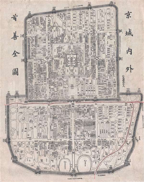
Jīngchéng nèiwài shǒu shàn quán tú / Premier Full Map of the Capital City's Interior and Exterior / 京城內外首善全圖
1850 (undated) 23 x 21 in (58.42 x 53.34 cm) 1: 17000
1850 (undated) 23 x 21 in (58.42 x 53.34 cm) 1: 17000
Description
An exceptional c. 1850 Chinese issue Qing Dynasty map of Beijing or Peking, China. This map details the Qing Dynasty walled city of Beijing and was used for administrative purposes. Important buildings, as well as with city and Forbidden City walls, are drawn in profile – a very traditional Chinese approach. In some cases, the dynasty in which important buildings were constructed is noted, so in essence this map covers Beijing's history over three Imperial Dynasties, the Yuan, the Ming, and the Qing. Numerous streets and avenues as well as many hutong - traditional alleyways associated with siheyuan or traditional courtyard residences- are additionally identified. Many of these have vanished today, making this an exceptional record of 'Old Beijing' on the cusp of change.
This map may look familiar to some. In 1900, following the Boxer Rebellion, occupying European and Japanese forces needed an accurate map of the city to divide it into various zones of occupation. With no more recent surveys available, they turned to an old Qing administrative plan – this map – for which the original plates survived. Using an overprinting technique, they added additional detail regarding the new occupation zones. Variants were issued in sloppily engraved Russian, English, German, French and Japanese. That map (Boxer Rebellion Map), issued in 1900 is cartographically similar, since it appears to have been based upon the same plate, but the overprinting makes it a very different map. The Chinese original, offered here, printed roughly 40-45 years earlier, is far rarer and is uncommon outside of institutional collections in China.
This map may look familiar to some. In 1900, following the Boxer Rebellion, occupying European and Japanese forces needed an accurate map of the city to divide it into various zones of occupation. With no more recent surveys available, they turned to an old Qing administrative plan – this map – for which the original plates survived. Using an overprinting technique, they added additional detail regarding the new occupation zones. Variants were issued in sloppily engraved Russian, English, German, French and Japanese. That map (Boxer Rebellion Map), issued in 1900 is cartographically similar, since it appears to have been based upon the same plate, but the overprinting makes it a very different map. The Chinese original, offered here, printed roughly 40-45 years earlier, is far rarer and is uncommon outside of institutional collections in China.
Condition
Very good. Some repaired wormholes. Backed on archival tissue for stability. Some soiling.
References
OCLC 495045988.