This item has been sold, but you can get on the Waitlist to be notified if another example becomes available, or purchase a digital scan.
1938 Map of the Grounds of the Summer Palace (Yiheyuan), Beijing
BeijingSummerPalace-yiheyuan-1938$425.00


Title
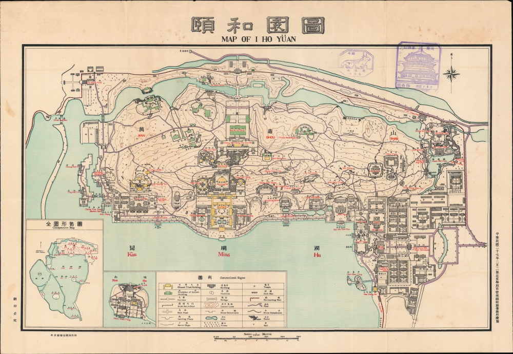
頤和園圖 / Map of I Ho Yüan.
1938 (dated) 20 x 30 in (50.8 x 76.2 cm) 1 : 2000
1938 (dated) 20 x 30 in (50.8 x 76.2 cm) 1 : 2000
Description
This is a 1938 map of the Summer Palace (頤和園, Yiheyuan) was produced by the palace itself, then operated as a museum by the municipality of Beijing.
A legend at bottom explains symbols and shading employed throughout. A 'conspective' inset map at bottom-left provides an overview of the entire palace grounds, including the Western (西湖) and Southern (南湖) Lakes, and Nanhu Island (南湖島), which itself is depicted in an adjacent inset. Two purple stamps appear near top that record visits to a bronze ox and Tower of Buddhist Incense on Longevity Hill.
Like China as a whole, the history of the Summer Palace in the late Qing is less illustrious. It was ransacked and badly damaged by French and British troops during the Second Opium War (1856 - 1860). The Empress Dowager Cixi (de facto r. 1861 - 1908) attempted to revive the palace, perhaps by skimming money that was allocated for modernizing China's navy, but they were damaged by foreign troops again during the 1899 Boxer Uprising. With the fall of the Qing, the palace briefly became the private property of the imperial family before being nationalized and opened as a park, allowing commoners to walk among the grounds that recently were only accessible to a small handful of people (members of the imperial family, eunuch advisors, and favored concubines).
The present map also was produced in the context of the Second Sino-Japanese War (1937 - 1845), which began in earnest just the year prior near Beijing. The city itself had been under increasing Japanese influence throughout the 1930s and, while the Qing were not especially well-regarded by the Japanese or Chinese government at the time, imperial relics were a potentially powerful symbolic tool in the war (Japanese troops even attempted to remove entire pavilions from the palace near the end of the conflict).
A Closer Look
Oriented towards the north, the map takes in the Summer Palace (Yiheyuan). The palace grounds total roughly 1 square mile, much of which is taken up by the artificial Kunming Lake and other waterways. The terrestrial portion of the palace is dominated by Longevity Hill (萬壽山), standing some 200 feet above the flat terrain of northwest Beijing. Despite its relatively small size, the grounds include dozens of ornate pavilions, pagodas, gardens, bridges, and walkways, including the Long Corridor (长廊), inlaid with exquisite murals.A legend at bottom explains symbols and shading employed throughout. A 'conspective' inset map at bottom-left provides an overview of the entire palace grounds, including the Western (西湖) and Southern (南湖) Lakes, and Nanhu Island (南湖島), which itself is depicted in an adjacent inset. Two purple stamps appear near top that record visits to a bronze ox and Tower of Buddhist Incense on Longevity Hill.
Historical Context
Inspired by the topography of southern China, the palace is considered a masterpiece in China's impressive tradition of landscape design. Like much of Beijing, including the Forbidden City, the history of the Summer Palace dates back several centuries before the Qing (1644 - 1912). A succession of imperial dynasties built, rebuilt, and elaborated Beijing (known by several names, including Yanjing). A palace had existed in this part of Beijing since the Jin Dynasty in the late 12th century, but the palace as it appears today is a relatively recent creation, developed in the reign of the Qing Qianlong Emperor (r. 1735 - 1796), who devoted special attention to northwest Beijing. At that time, a system of lakes and waterways developed during the Yuan Dynasty was greatly expanded, resulting in Kunming Lake as it appears here. Structures and gardens were erected, meant to resemble famous buildings and natural sites in southern China, in a way turning the palace grounds into a miniature scale model of a large portion of the realm. Despite these elaborations, the palace was too small to include long-term accommodations and the emperor generally spent less than twenty-four hours there on any given trip.Like China as a whole, the history of the Summer Palace in the late Qing is less illustrious. It was ransacked and badly damaged by French and British troops during the Second Opium War (1856 - 1860). The Empress Dowager Cixi (de facto r. 1861 - 1908) attempted to revive the palace, perhaps by skimming money that was allocated for modernizing China's navy, but they were damaged by foreign troops again during the 1899 Boxer Uprising. With the fall of the Qing, the palace briefly became the private property of the imperial family before being nationalized and opened as a park, allowing commoners to walk among the grounds that recently were only accessible to a small handful of people (members of the imperial family, eunuch advisors, and favored concubines).
The present map also was produced in the context of the Second Sino-Japanese War (1937 - 1845), which began in earnest just the year prior near Beijing. The city itself had been under increasing Japanese influence throughout the 1930s and, while the Qing were not especially well-regarded by the Japanese or Chinese government at the time, imperial relics were a potentially powerful symbolic tool in the war (Japanese troops even attempted to remove entire pavilions from the palace near the end of the conflict).
Publication History and Census
This map was produced in February 1938 (Minguo 27) by the palace itself, then operated as a museum managed by the municipality of Beijing (北京特別市管理頤和園事務所). It was printed by the Guohua Printshop in Beijing (北京國華印刷局). The text at bottom-right indicates that this is a second edition. The University of Washington, Harvard University, and Bukkyo University hold examples of this map dated to 1934, assuredly the first edition, while the National Diet Library holds an example of the present edition. It appears that a third edition was printed in 1942 and is noted among the holdings of the National Central Library in Taipei.Condition
Very good. Light wear along original fold lines. Light soiling.
References
OCLC 740006631, 1292100042.