This copy is copyright protected.
Copyright © 2025 Geographicus Rare Antique Maps
1827 Thomas Hurd First Admiralty Chart of Bermuda
Bermuda-hurd-1827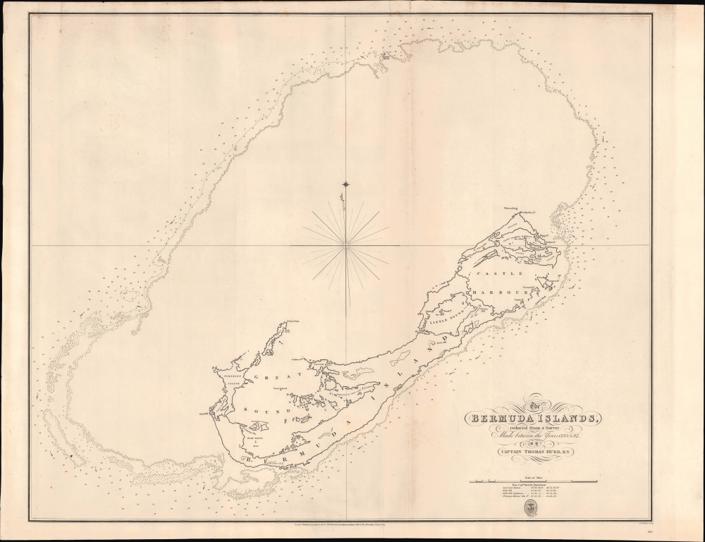


Thomas Hannaford Hurd (January 30, 1747 - April 29, 1823) was a hydrographer and Royal Navy officer who rose to become Hydrographer of the Navy in 1808, succeeding Alexander Dalrymple, who had been the first holder of that office. Hurd was born in Plymouth, an ideal location for a future mariner. He joined the Royal Navy in 1768 and served along the coasts North America, gaining his first exposure to hydrographic methods, learning from Samuel Holland (1728 - 1801) while both were aboard the HMS Canceaux. Holland and Hurd were part of an extensive surveying project overseen by J.F.W. DesBarres (1721 - 1824) combining both land surveys and hydrography along the North American coast; the result of their efforts was the seminal work, the Atlantic Neptune, the most important maritime atlas of its day (first published in 1777). Hurd saw extensive action as an officer (lieutenant) under Lord Howe during the Anglo-French War (1778 - 1783), a global conflict that was largely an ancillary to the American War of Independence. At the conclusion of the war, Howe recommended Hurd as surveyor-general of Cape Breton, a post he held for only one year before being dismissed by the same Desbarres he had previously worked for, who was at the time the Lieutenant-Governor of Cape Breton Colony. Between 1789 and 1797, Hurd was tasked with producing a survey of the Atlantic archipelago Bermuda, which had maintained some English settlers and an ambivalent relationship with England itself, being more economically connected with the American colonies, and later the United States. Hurd's resulting highly-detailed survey of Bermuda demonstrated its advantages as a naval station, and his subsequent advocacy of a strong British presence there were instrumental in determining the later history of the archipelago, with it becoming a major British naval station in the early 19th century. During and after his work on Bermuda, Hurd was promoted through the ranks of the Royal Navy, to commander and then post-captain. In 1804, he undertook a survey of Brest and the nearby portions of the French coast - crucial information given the area's proximity to England and the persistent British-French tensions at the time. In 1808, due to his surveying experience, Hurd succeeded Alexander Dalrymple as Hydrographer of the Navy upon the latter's death. As Dalrymple had been the inaugural holder of the office, the post was still in the process of formation and was influenced by complex politics between the Hydrographer, based in the Hydrographic Office, and the Admiralty Board, which oversaw the new office. Still, the Hydrographic Office was a relatively small and experimental corner in the wide universe of expenditures and issues overseen by the Admiralty Board, providing the Hydrographers with a degree of autonomy. According to research by Adrian Webb, who has written a biography of Hurd covering his fifteen years of work as Hydrographer, Hurd was an effective manager and greatly improved the quality and consistency of the office's work. He was also adept at navigating the politics of the Admiralty and befriended the powerful Robert Dundas, 2nd Viscount Melville. This allowed him, for example, to gain promotions for skilled surveyors under his purview, thus improving the office's output and in turn making it more important as a source of critical information for the Admiralty writ large. Perhaps most significantly, Hurd was a proponent of sharing hydrographical data with hydrographers from other countries, even suspect ones like France, allowing for rapid dissemination of the best information across borders. He also made the charts his office produced available to the public, saving countless merchant ships from damage or sinking as a result of incomplete or out-of-date hydrographical charts. Hurd also served as the Superintendent of Chronometers and a Commissioner on the Board of Longitude during the period when chronometers became the preferred method for determining longitude (as opposed to astronomical observations). More by this mapmaker...
The British Admiralty Office (1795 - Present) or the United Kingdom Hydrographic Office refers to the Branch of the English government that is responsible for the command of the British Navy. In 1795 King George III created the United Kingdom Hydrographic Office, known in short as the U.K.H.O., to provide top notch nautical charts to the vast Royal Navy. Prior the founding of the Admiralty the surveying and creation of nautical charts was primarily a commercial venture wherein the cartographer himself, more of than not, actually financed the printing of his own material. The great navigator Cook himself is known to have scrambled for funds to publish his own seminal charts - the most important and advanced of the period. The system of privately funded nautical mapping and publishing left vast portions of the world uncharted and many excellent charts unpublished. King George III, responding significant loss in trade revenue related to shipwrecks and delay due to poor charts, recognized the need for an institutionalized government sponsored cartographic agency - the Admiralty. The first head of the Admiralty, a position known as Hydrographer, was the important cartographer Alexander Dalrymple. Dalrymple started by organizing and cataloging obtainable charts before initiating the laborious process of updating them and filling in the blanks. The first official Admiralty Chart appeared in 1800 and detailed Quiberon Bay in Brittany. By 1808 the position of Hydrographer fell to Captain Thomas Hurd. Hurd advocated the sale of Admiralty charts to the general public and, by the time he retired in 1829, had issued and published some 736 charts. Stewardship of the organization then passed to Rear Admiral Sir Francis Beaufort. It was under Beaufort's administration that the Admiralty truly developed as a "chart making" as opposed to a "chart cataloging" institution. Beaufort held his post from 1829 to 1854. In his 25 years at the Admiralty Beaufort created nearly 1500 new charts and sponsored countless surveying and scientific expeditions - including the 1831 to 1836 voyage of the H.M.S. Beagle. By 1855 the Admiralty's chart catalog listed some 1,981 charts. Learn More...
John Walker (1787 - April 19, 1873) was a British map seller, engraver, lithographer, hydrographer, geographer, draughtsman, and publisher active in London during the 19th century. Walker published both nautical charts and geographical maps. His nautical work is particularly distinguished as he was an official hydrographer for the British East India Company, a position, incidentally, also held by his father of the same name. Walker's maps, mostly published after 1827, were primarily produced with his brothers Charles Walker and Alexander Walker under the imprint J. and C. Walker. Among their joint projects are more than 200 maps for the influential Society for the Diffusion of Useful Knowledge Atlas (SDUK). In addition they published numerous charts for James Horsburgh and the British Admiralty Hydrographic Office, including Belcher's important map of Hong Kong and Carless' exploratory map of Karachi. The J. and C. Walker firm continued to publish after both Walkers died in the 1870s. Learn More...
Copyright © 2025 Geographicus Rare Antique Maps | Geographicus Rare Antique Maps
This copy is copyright protected.
Copyright © 2025 Geographicus Rare Antique Maps