This copy is copyright protected.
Copyright © 2025 Geographicus Rare Antique Maps
Digital Image: 1874 J. S. Bird and Company City Plan or Map of Big Rapids, Michigan
BigRapidsMich-jsbirdco-1874_d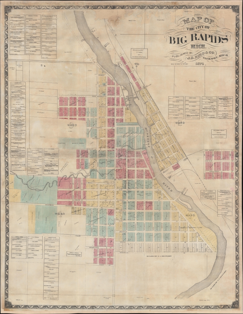

FOR THE ORIGINAL ANTIQUE MAP, WITH HISTORICAL ANALYSIS, CLICK HERE.
Digital Map Information
Geographicus maintains an archive of high-resolution rare map scans. We scan our maps at 300 DPI or higher, with newer images being 600 DPI, (either TIFF or JPEG, depending on when the scan was done) which is most cases in suitable for enlargement and printing.
Delivery
Once you purchase our digital scan service, you will receive a download link via email - usually within seconds. Digital orders are delivered as ZIP files, an industry standard file compression protocol that any computer should be able to unpack. Some of our files are very large, and can take some time to download. Most files are saved into your computer's 'Downloads' folder. All delivery is electronic. No physical product is shipped.
Credit and Scope of Use
You can use your digial image any way you want! Our digital images are unrestricted by copyright and can be used, modified, and published freely. The textual description that accompanies the original antique map is not included in the sale of digital images and remains protected by copyright. That said, we put significant care and effort into scanning and editing these maps, and we’d appreciate a credit when possible. Should you wish to credit us, please use the following credit line:
Courtesy of Geographicus Rare Antique Maps (http://www.geographicus.com).
How Large Can I Print?
In general, at 300 DPI, you should at least be able to double the size of the actual image, more so with our 600 DPI images. So, if the original was 10 x 12 inches, you can print at 20 x 24 inches, without quality loss. If your display requirements can accommodate some loss in image quality, you can make it even larger. That being said, no quality of scan will allow you to blow up at 10 x 12 inch map to wall size without significant quality loss. For more information, it is best consult a printer or reprographics specialist.
Refunds
If the high resolution image you ordered is unavailable, we will fully refund your purchase. Otherwise, digital images scans are a service, not a tangible product, and cannot be returned or refunded once the download link is used.
Judson Slatford Bird (October 9, 1846 - March 19, 1882) was an American civil engineer. Born on a farm outside Ann Arbor, Michigan, Bird attended the University of Michigan and graduated in 1870. After graduating, Bird published city maps under the imprint Taylor and Bird. In 1871 he was appointed City Engineer for Jackson, Michigan, and, by 1872, was operating the firm Bird, Mickle, and Waters on the side and publishing a map of 'one city per month'. In 1874 he was operating J. S. Bird and Company in Jackson, Michigan. By 1876 Bird had relocated to Blue Rapids, Kansas, where he was part of the Bird and Mickle Map Company with George W. Mickle. The firm published a large map of Marshall County, Kansas, in 1880, per his obituary. From newspaper articles we know that Bird and Mickle also published a map of Nemaha County, Nebraska; Davis County, Kansas; and Dickinson County, Kansas. They also published a plat book of Clay County, Kansas. However, another newspaper notice from 1878 stated that the Bird and Mickle Map Company had been 'adjudged bankrupts on their own petition'. Bird died on the evening of March 19, 1882, 'of cerebro-spinal affection' (likely meningitis). He married Mary Emily Sears (1838 - May 23, 1934) in 1873, with whom he had two children. More by this mapmaker...
Copyright © 2025 Geographicus Rare Antique Maps | Geographicus Rare Antique Maps
This copy is copyright protected.
Copyright © 2025 Geographicus Rare Antique Maps