This item has been sold, but you can get on the Waitlist to be notified if another example becomes available, or purchase a digital scan.
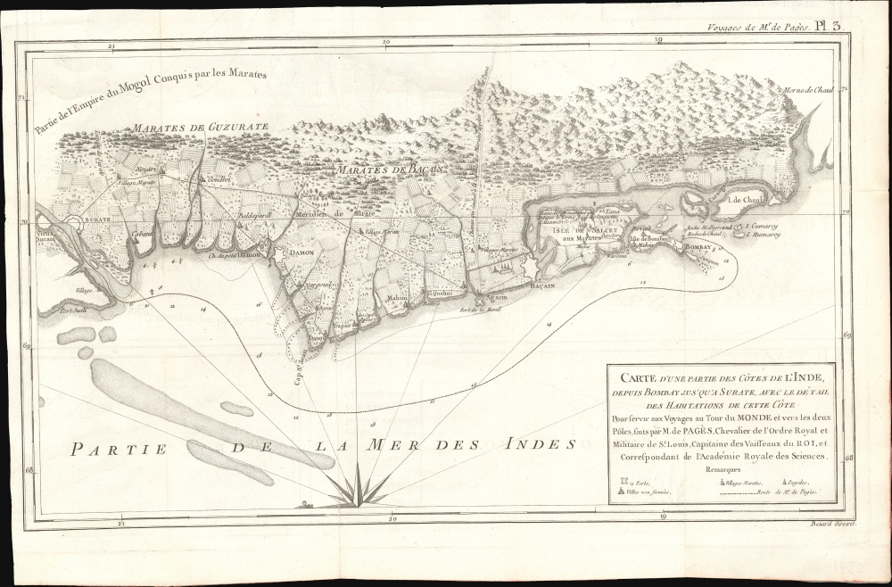
1782 Pàges Map of Bombay / Mumbai, India
Bombay-pages-1782$300.00

Title
Carte d'Une Partie des Côtes de L'Inde, depuis Bombay jus'qu'a Surate, avec le détail des Habitations de cette Côte.
1782 (undated) 10.5 x 16.5 in (26.67 x 41.91 cm) 1 : 11000000
1782 (undated) 10.5 x 16.5 in (26.67 x 41.91 cm) 1 : 11000000
Description
This is an unusual 1782 Pierre-Marie-François Pàges map of Bombay, India, and its vicinity. The map is uncommon in that it details not just the British fortification on Bombay Island, but also the surrounding Gujarat countryside and communities.
A Closer Look
Oriented to the east, coverage embraces from the fortified Gujarati city of Surat to the British Fort George on Bombay Island. Several Gujarati villages to the north and east of Bombay are noted. There are a few depth soundings marking approaches to Fort George. On Salcet, the cartographer notes and partially illustrates a ruined monument marking the farthest point of Alexander the Great's conquests. We have found no other references to this monument.Pàges Voyage (1776 - 1776)
Pierre-Marie-François Pàges, a French naval officer and explorer, undertook an ambitious 1767-76 voyage that circumnavigated the globe and explored a vast range of territories. He left France for the Caribbean in 1767, exploring the West Indies and then traveling through Louisiana and the Mississippi Valley in North America. Pàges crossed overland through Texas, where he documented the lives of indigenous peoples, landscapes, and wildlife. From there, he sailed across the Pacific, visiting the Philippines, the Dutch East Indies (modern-day Indonesia), and China, before making his way to India and traveling overland through Persia, Syria, and the Middle East. After years of exploration, he returned to France in 1776. Pàges recorded his experiences and observations in his 1782 Voyages Autour du Monde et vers les Deux Pôles ('Voyages Around the World and to the Two Poles'), which offered detailed accounts of the cultures, environments, and political conditions of the regions he visited. His work reflected the spirit of the Enlightenment, emphasizing scientific inquiry, curiosity, and interconnectedness.Publication History and Census
This map was engraved by Robert Benard for publication in Pàges 1782 Voyages Autour du Monde et vers les Deux Pôles. The separate map is not cataloged separately, but the full work is well represented institutionally.Cartographer
Robert Bénard (1734 - c. 1785) was a French engraver. Born in Paris, Bénard is best known for supplying a significant number of plates (at least 1,800) for the Encyclopédie published by Diderot and Alembert. He also is remembered for his work with the Académie des Sciences, most notably the Descriptions des Arts et Métiers More by this mapmaker...
Source
Pàges, Pierre-Marie-François, Voyages Autour du Monde et vers les Deux Poles, par Terre et par Mer pendant les Années 1767, 1768, 1769, 1770, 1771, 1773, 1774 et 1776, (Paris: Chez Moutard) 1782.
Condition
Very good. Slight wear on old fold lines.
References
Rumsey 11230.004.

