This copy is copyright protected.
Copyright © 2025 Geographicus Rare Antique Maps
Digital Image: 1807 Buache Map of Boston, Massachusetts
Boston-buache-1807_d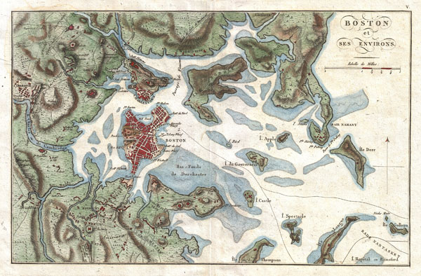

FOR THE ORIGINAL ANTIQUE MAP, WITH HISTORICAL ANALYSIS, CLICK HERE.
Digital Map Information
Geographicus maintains an archive of high-resolution rare map scans. We scan our maps at 300 DPI or higher, with newer images being 600 DPI, (either TIFF or JPEG, depending on when the scan was done) which is most cases in suitable for enlargement and printing.
Delivery
Once you purchase our digital scan service, you will receive a download link via email - usually within seconds. Digital orders are delivered as ZIP files, an industry standard file compression protocol that any computer should be able to unpack. Some of our files are very large, and can take some time to download. Most files are saved into your computer's 'Downloads' folder. All delivery is electronic. No physical product is shipped.
Credit and Scope of Use
You can use your digial image any way you want! Our digital images are unrestricted by copyright and can be used, modified, and published freely. The textual description that accompanies the original antique map is not included in the sale of digital images and remains protected by copyright. That said, we put significant care and effort into scanning and editing these maps, and we’d appreciate a credit when possible. Should you wish to credit us, please use the following credit line:
Courtesy of Geographicus Rare Antique Maps (http://www.geographicus.com).
How Large Can I Print?
In general, at 300 DPI, you should at least be able to double the size of the actual image, more so with our 600 DPI images. So, if the original was 10 x 12 inches, you can print at 20 x 24 inches, without quality loss. If your display requirements can accommodate some loss in image quality, you can make it even larger. That being said, no quality of scan will allow you to blow up at 10 x 12 inch map to wall size without significant quality loss. For more information, it is best consult a printer or reprographics specialist.
Refunds
If the high resolution image you ordered is unavailable, we will fully refund your purchase. Otherwise, digital images scans are a service, not a tangible product, and cannot be returned or refunded once the download link is used.
Jean-Nicolas Buache de La Neuville (1741 - 1825) was a French Hydrographer and Geographer active in the late 18th and early 19th centuries. He is a nephew of the well known theoretical cartographer Phillip Buache. Like Phillip and De L'Isle, with whom his was also related, J. N. Buache held the position of Premier Geographe du Roi. J. N. Buache was an ardent supporter of his uncle, Phillip Buache's, radical cartographic ideas regarding the speculated existence of a "northwest passage". Like Phillip, Jean Nicholas believed that theoretical cartography, that is, applying geographical theories could fill in the blank places on the globe before actual explorers traveled there. While this approach did yield occasional minor success, it is the spectacular misjudgments, such as speculation on the Northwest Passage, for which it is best known. Nonetheless, Jean Nicholas had a distinguished career as a well respected cartographer both in France and abroad. He published a large corpus of maps in addition to various theoretical treatises on cartography and geography. More by this mapmaker...
Copyright © 2025 Geographicus Rare Antique Maps | Geographicus Rare Antique Maps
This copy is copyright protected.
Copyright © 2025 Geographicus Rare Antique Maps