1561 / 1574 Ruscelli British Isles
BritishIsles-ruscelli-1561$750.00


Title
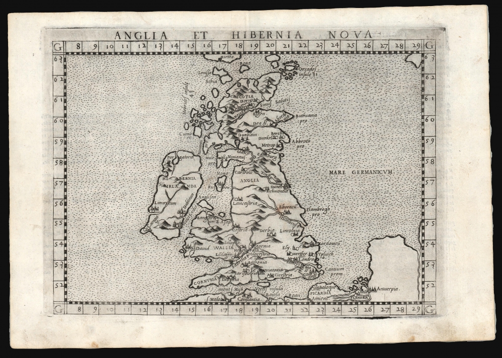
Anglia et Hibernia Nova.
1561 (undated) 7.25 x 9.75 in (18.415 x 24.765 cm) 1 : 10500000
1561 (undated) 7.25 x 9.75 in (18.415 x 24.765 cm) 1 : 10500000
Description
This is a handsome example of Girolamo Ruscelli's 1561 / 1574 map of the British Isles. Of the maps prepared for Ruscelli's Ptolemy, it is among the most important: while most were larger, superior copies of the maps appearing in the 1548 Gastaldi Ptolemy, this map was a unique, updated work.
The Map
This elegant copperplate engraving presents the British Isles of the contemporary era, oriented to the north and reaching as far as the Orkney Islands; at the top-center is Hirtha, the largest island of the St. Kilda Archipelago. On the lower right are the coasts of France and the Low Countries, including the cities of Mont Saint-Michel, Amiens, Antwerp, and others. The ocean areas are indicated with neat stippling. The borders are marked with latitude and longitude.A New Map
Gastaldi's 1548 Ptolemy had contained a modern map of the British Isles, and it was titled similarly to this one (Anglia E Hibernia Nova). But it is not the same map. Gastaldi's map showed a radically different outline and a different array of placenames. In fact, the 1548 map was obsolete before it was committed to print since it was based on the 1513 Waldseemuller map: a strange shortfalling by Gastaldi, who was one of the greatest geographers of his era. Ruscelli's map drew from a much more current source and must be viewed as a new composition.From an English Source
In 1546, the English Roman Catholic priest George Lily - exiled along with his patron from Henry VIII's England - was living and working in Rome. In addition to his contributions to Italian histories of the British Isles, Lily produced the first separately published map of the British Isles. Bafflingly, it did not impact Gastaldi's Anglia E Hibernia at all. Ruscelli was clearly aware of it, however, and drew upon it for his modern map of the British Isles in preference to the antiquated Gastaldi. Ruscelli's map draws both its outline and data from Lily's map. Constrained by size, Ruscelli's map does not reproduce all of Lily's data; Ruscelli focuses primarily on cathedral cities rather than those of mercantile importance. Nevertheless, Ruscelli's map is the earliest acquirable derivative of Lily's map. Although its superiority was immediately recognized and it was swiftly pirated, the resultant Lafreri-type editions of Lily's map are all extremely rare and exorbitantly expensive.Publication History and Census
The map was engraved by Giulio Sanuto for inclusion in Ruscelli's La geografia di Claudio Tolomeo Alessandrino, and the plate appeared in all editions of that work. The maps of the 1561 edition were engraved two-to-a-plate, and consequently, the platemark runs off the edge of the sheet at the top for the 1561, 1562, and 1564 printings of the work. Afterward, the plates were divided, and examples from 1574 onwards, as here, exhibit a platemark all around the map. In 1598, a ship and two sea monsters were added, as well as spurious mountains and trees in the low countries, shown empty here. The present example conforms typographically to the 1574 edition. We see four examples of this separate map cataloged in OCLC in various editions.CartographerS
Girolamo Ruscelli (1500 - 1566) was an Italian polymath, humanist, editor, and cartographer active in Venice during the early 16th century. Born in Viterbo, Ruscelli lived in Aquileia, Padua, Rome and Naples before relocating to Venice, where he spent much of his life. Cartographically, Ruscelli is best known for his important revision of Ptolemy's Geographia, which was published posthumously in 1574. Ruscelli, basing his work on Gastaldi's 1548 expansion of Ptolemy, added some 37 new "Ptolemaic" maps to his Italian translation of the Geographia. Ruscelli is also listed as the editor to such important works as Boccaccio's Decameron, Petrarch's verse, Ariosto's Orlando Furioso, and various other works. In addition to his well-known cartographic work many scholars associate Ruscelli with Alexius Pedemontanus, author of the popular De' Secreti del R. D. Alessio Piemontese. This well-known work, or "Book of Secrets" was a compilation of scientific and quasi-scientific medical recipes, household advice, and technical commentary on a range of topics that included metallurgy, alchemy, dyeing, perfume making. Ruscelli, as Alexius, founded a "Academy of Secrets," a group of noblemen and humanists dedicated to unearthing "forbidden" scientific knowledge. This was the first known experimental scientific society and was later imitated by a number of other groups throughout Europe, including the Accademia dei Secreti of Naples. More by this mapmaker...
George Lily (???? - 1559) was an English Roman Catholic priest, humanist, writer, and cartographer. He was born in London, although the date is not known. His father was the grammarian William Lily, who was also master of St. Paul's School; George likely attended school there. He is thought to have gone to Magdalen College, Oxford, in 1528. He entered the service of Reginald Pole, following him into exile in France and Italy. By 1535, he was at the University of Padua; by 1538 he was living in Rome. His association with the Roman Catholic Pole led to his being outlawed in England for treason in 1543. While in Italy, he contributed to Giovio's history of the British Isles as well as producing some of his own histories and biographies. His works included a history of the Wars of the Roses and a genealogy of the Kings of England. Probably intending the work to accompany Giovo's history, Lily drew a the first detailed, printed map of the British Isles from an English source; this would be printed in Rome in 1546. Based in some respects upon the 14th century Gough map, Lily's map improved sharply on its medieval precursor, particularly with respect to the Scottish coast. He would not return to Engand until 1555, when England returned to Catholicism under Queen Mary I. Pole became Archbishop of Canterbury in March 1556, while Lily became his domestic chaplain.He was made first prebend of Canterbury Cathedral in 1558. It has been suggested that he took part in the production of the large-scale 1559 'Copperplate Map' of London prior to his death that year. Learn More...
Giulio Sanuto (fl. 1540 – 1580) was a Venetian engraver. He was born the illegitimate son of Cavaliere Francesco di Angelo Sanuto; With his brother, the cartographer and scientific instrument maker Livio Sanuto (1520 – 1576) he produced an array of some of the most important geographical works produced in Venice during the second half of the sixteenth century. These included a 27-inch globe and the 1588 12-sheet atlas, Geografia della Africa. Giulio's career is singluar among Venice's engraves in that it appears to have been equally based on artistic, figurative work as well as his cartographic works. Giulio is more broadly known for a small but sought-after selection of decorative engravings; no more than twelve of these can be attributed confidently to him, including the monumental Apollo and Marsyas, measuring over 1.30 meters wide. Whilst Sanuto's engravings were generally based upon the designs of other artists, his work was both ambitious and grand, and he often signed these works. Learn More...
Source
Ruscelli, G., La Geografia di Claudio Tolomeo Alessandrino…, (Venice: Giordano Ziletti) 1574.
Beginning in 1561, Girolamo Ruscelli published this important, expanded edition of Giacomo Gastaldi's 1548 Ptolemy. Its maps, engraved in Venice by Giulio Sanuto, were in the main based directly upon those in Gastaldi's 1548 work. The maps were larger format than Gastaldi's, however, and Sanuto's engraving was far clearer and more legible than those appearing in the 1548 work. There are some important additions that distinguish Ruscell's Ptolemy from Gastaldi's. Ruscelli's work contained a map of the habitable world according to Ptolemy, which the Gastaldi lacked; also, the double-hemisphere map appearing in the Ruscelli was new and did not appear in the Gastaldi. Ruscelli's modern map of England was based on the work of George Lily, rather than the Waldseemüller-derived map appearing in the Gastaldi; the Ruscelli is the earliest generally acquirable map of England based on knowledge from someone who lived there. In a fateful innovation, Ruscelli's work included Septentrionalium partium nova tabula,the first copy of Nicolo Zeno's 1558 fraud Carta da Navegar, which introduced a novel mapping of the north parts of the world, including the phantom islands of Frisland, Icaria, Drogeo and Estotiland. Had Ruscelli not copied the Zeno - which had a narrow, brief publication - this preposterous geography would have probably not taken hold. Its inclusion in Ruscelli's beautiful, authoritative and popular work would lead to the adoption of the Zeno map by Mercator, Ortelius, Plancius and their successors, baffling scholars for centuries. Ruscelli's Ptolemy had a long publication history, cementing the influence of the work. It appeared both in Italian and Latin editions, all printed in Venice, throughout the latter 16th century:
- 1561 La Geographia di Claudio Tolomeo Alessandrino, Italian. Venice, Vincenzo Valgrisi.
- 1562 Geographia Cl. Ptolemaei Alexandrini, Latin. Venice, Vincenzo Valgrisi.
- 1564 La Geographia di Claudio Tolomeo Alessandrino, Italian. Venice, Giordano Ziletti.
- 1564 Geographia Cl. Ptolemaei Alexandrini, Latin. Venice, Giordano Ziletti.
- 1574 La Geographia di Claudio Tolomeo Alessandrino, Italian. Venice, Giordano Ziletti.
- 1598 Geographia di Claudio Tolomeo Alessandrino, Italian. Venice, heirs of Melchoir Sessa.
- 1599 Geographia di Claudio Tolomeo Alessandrino, Italian. Venice, heirs of Melchoir Sessa.
Condition
Very good. Some marginal soiling, else excellent.
References
OCLC 500415513. Rumsey 11311.065. (1561) Shirley, R., Early Printed Maps of the British Isles, 1477-1650, #111.