This item has been sold, but you can get on the Waitlist to be notified if another example becomes available, or purchase a digital scan.
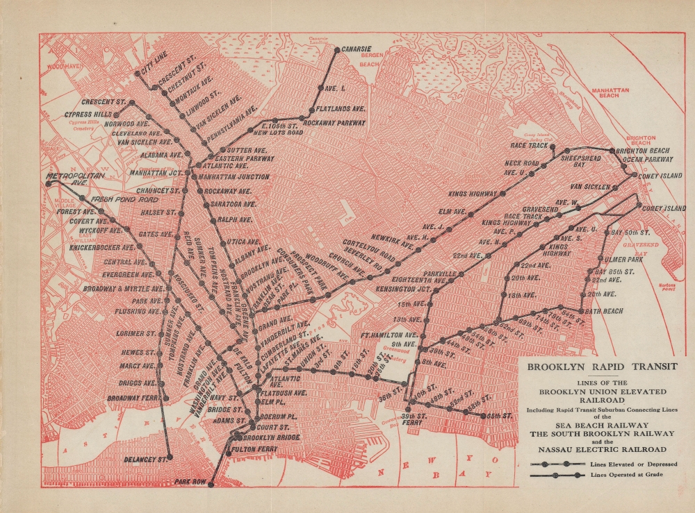
1903 Map of the Brooklyn Rapid Transit System
BrooklynRapidTransit-unknown-1903$150.00

Title
Brooklyn Rapid Transit: Lines of the Brooklyn Union Elevated Railroad, including rapid transit suburban connecting lines of the Sea Beach Railway, the South Brooklyn Railway, and the Nassau Electric Railroad.
1903 (undated) 8 x 11 in (20.32 x 27.94 cm) 1 : 55700
1903 (undated) 8 x 11 in (20.32 x 27.94 cm) 1 : 55700
Description
A wonderful c. 1903 transit map depicting the lines belonging to the Brooklyn Rapid Transit (BRT) Company, one of the main predecessors to today's New York City Subway system. Created in 1896, the BRT was designed as a holding company that quickly consolidated the various lines in Brooklyn, some of which retain their earlier names here.
Afterwards, elevated lines were built in quick succession to carry passengers between suburban areas of Brooklyn and downtown Brooklyn, with ferry connections to Manhattan (and, from 1883, the Brooklyn Bridge). These elevated lines were merged and rechristened by the BRT as the Brooklyn Union Elevated. The South Brooklyn Railway was clever in that its terminus was a ferry terminal linking with Manhattan (now the site of the South Brooklyn Marine Terminal).
The rail building spree vacuumed up investments and met a dire public need, but the intense competition also bankrupted most of the companies within a handful of years. Thus, the BRT was created with the aim of acquiring and consolidating existing lines, making them a more coherent integrated whole. Within just four years, the BRT had purchased all the existing lines in Brooklyn except for the Coney Island and Brooklyn Railroad and a short line in Red Hook (these were also eventually acquired by BRT). In the following decades, BRT expanded the system even more, including subway lines in downtown Brooklyn and into Manhattan. However, the company suffered the same fate as its predecessors, investing huge amounts of money up front to develop excellent service, leaving it unprepared for financial difficulties. These came in the mid-late 1910s, as the company was legally barred from raising fares despite high inflation. The fixed-fare policy, despised by the BRT, was the brainchild of Mayor John Francis Hylan, who ironically had worked for the Brooklyn Union Elevated Railroad before going into law and then politics. A horrific accident in 1918 that killed dozens also hurt the company's reputation. By 1923, it was bankrupt, and was reorganized as the Brooklyn-Manhattan Transit Corporation (BMT), which itself was acquired by the city in 1940.
A Closer Look
The various lines of the BRT are illustrated, and the portions that are depressed (via underpass) or elevated are designated differently from those at grade (at ground level). Two lines (operated by the Nassau Electric Railroad) connect directly with Manhattan via the Williamsburg and Brooklyn Bridges. Barely perceptible are red concentric circles that mark out miles from the Brooklyn Bridge. Though some lines seen here are now defunct and others have had significant changes (especially in station names), the outlines of several of today's train services are readily apparent.Evolution of Subways, Railways, and Streetcars in Brooklyn
In the closing decades of the 19th century, Brooklyn grew at a tremendous rate, and public transit was desperately needed to accommodate the city's population. Several railways were created in the 1860s - 1880s to connect the urban core of Brooklyn to beachside resorts on Coney Island (among these lines was the New York and Sea Beach Railroad, later simply the Sea Beach Railway).Afterwards, elevated lines were built in quick succession to carry passengers between suburban areas of Brooklyn and downtown Brooklyn, with ferry connections to Manhattan (and, from 1883, the Brooklyn Bridge). These elevated lines were merged and rechristened by the BRT as the Brooklyn Union Elevated. The South Brooklyn Railway was clever in that its terminus was a ferry terminal linking with Manhattan (now the site of the South Brooklyn Marine Terminal).
The rail building spree vacuumed up investments and met a dire public need, but the intense competition also bankrupted most of the companies within a handful of years. Thus, the BRT was created with the aim of acquiring and consolidating existing lines, making them a more coherent integrated whole. Within just four years, the BRT had purchased all the existing lines in Brooklyn except for the Coney Island and Brooklyn Railroad and a short line in Red Hook (these were also eventually acquired by BRT). In the following decades, BRT expanded the system even more, including subway lines in downtown Brooklyn and into Manhattan. However, the company suffered the same fate as its predecessors, investing huge amounts of money up front to develop excellent service, leaving it unprepared for financial difficulties. These came in the mid-late 1910s, as the company was legally barred from raising fares despite high inflation. The fixed-fare policy, despised by the BRT, was the brainchild of Mayor John Francis Hylan, who ironically had worked for the Brooklyn Union Elevated Railroad before going into law and then politics. A horrific accident in 1918 that killed dozens also hurt the company's reputation. By 1923, it was bankrupt, and was reorganized as the Brooklyn-Manhattan Transit Corporation (BMT), which itself was acquired by the city in 1940.
Publication History and Census
The map is undated, but as it includes the South Brooklyn Railway as part of the BRT, it must date from 1903 or later. The author is also unknown but was likely the BRT itself. It appears to be a slightly reduced-scale printing of the map 'Map of the borough of Brooklyn, N.Y., and vicinity showing the street railway system controlled by the Brooklyn Rapid Transit Co.,' (OCLC 897934210) the only known copy of which is held by the New York Public Library. The present map is not known to exist in any institutional collections and has no known history on the market.Condition
Excellent. Original fold lines visible.

