This item has been sold, but you can get on the Waitlist to be notified if another example becomes available, or purchase a digital scan.
1927 Bemporat City Map or Plan of Buenos Aires, Argentina
BuenosAires-bemporat-1927$237.50

Title
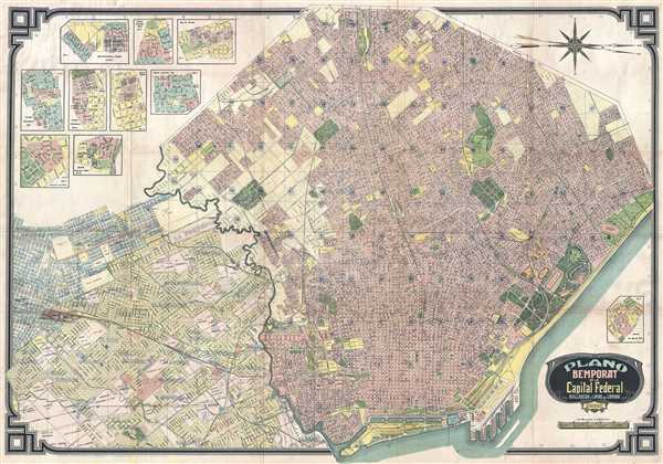
Plano Bemporat de la Capital Federal Avellaneda y Lomas de Zamora.
1927 (undated) 31.75 x 45 in (80.645 x 114.3 cm) 1 : 20000
1927 (undated) 31.75 x 45 in (80.645 x 114.3 cm) 1 : 20000
Description
This is a c. 1927 Oficina Cartografica Bemporat city map or plan of Buenos Aires, Argentina. The map depicts Buenos Aires from Banfield to Avenida Costanera (which is labeled as under construction) and the Rio de la Plata and from Avenida General Paz to the Rio de la Plata and Sarandi. Highly detailed, nearly all of the streets are labeled, along with numerous locations around the city. The train stations are easily recognizable, along with parks, such as the Parque Patricios and the Parque Chacabuco. The Parque de Febrero is illustrated in incredible detail, with the zoo, botanic garden, hippodrome among the labeled areas and several smaller gardens within the Parque de Febrero are illustrated in detail. Nine inset maps depicting neighborhoods in Buenos Aires are situated in the upper left corner, with a tenth located in the lower right corner.
This map was produced by Oficina Cartografica Bemporat c. 1927.
This map was produced by Oficina Cartografica Bemporat c. 1927.
Condition
Very good. Wear along original fold lines. Blank on verso.
References
OCLC 809130822.