This item has been sold, but you can get on the Waitlist to be notified if another example becomes available, or purchase a digital scan.
1656 Jansson Bird's Eye View of Cabo de Santo Agostinho, Brazil
CaboStAugustin-jansson-1656$225.00

Title
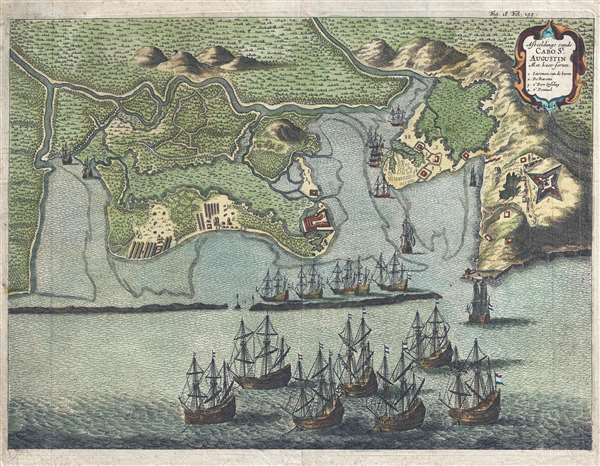
Afbeeldinge van de Cabo St. Augustin: Met haer forten.
1656 (undated) 11.25 x 15 in (28.575 x 38.1 cm)
1656 (undated) 11.25 x 15 in (28.575 x 38.1 cm)
Description
This is a rare 1656 Jan Jansson and Isaac Commelin view of Cabo de Santo Agostinho, Brazil illustrating a battle between the Dutch and the Portuguese. The view depicts Cabo de Santo Agostihno from the east. Dutch ships have amassed at the entrance to the harbor and several Portuguese forts and encampments occupy sites the coast and on the high ground above the harbor. A decorative title cartouche in the upper right corner includes four locations which are numerically identified, including the entrance to the harbor and Fort Gyseling.
The Dutch were in Brazil fighting with the Portuguese over access to trade in the region. The goal of the Dutch offensive was to capture as much land from the Portuguese as possible, in order to hinder Portuguese trade. Here, Dutch forces have chosen to attack Cabo de Santo Agostinho instead of Recife, a much larger city not far from Cabo de Santo Agostinho. The Portuguese believed Recife to be the more likely target, thus there was a higher concentration of troops in that city. By attacking Cabo de Santo Agostinho, the Dutch were able to capture the port and several settlements in the surrounding area, accomplishing their mission for the day.
This view was created and published by Jan Jansson in Isaac Commelin's book Histoire de la vie et actes memorables de Frederic Henry de Nassau Prince d'Orange in 1656. Today this map is quite scarce and there are few examples even in institutional collections.
CartographerS
Jan Jansson or Johannes Janssonius (1588 - 1664) was born in Arnhem, Holland. He was the son of a printer and bookseller and in 1612 married into the cartographically prominent Hondius family. Following his marriage he moved to Amsterdam where he worked as a book publisher. It was not until 1616 that Jansson produced his first maps, most of which were heavily influenced by Blaeu. In the mid 1630s Jansson partnered with his brother-in-law, Henricus Hondius, to produce his important work, the eleven volume Atlas Major. About this time, Jansson's name also begins to appear on Hondius reissues of notable Mercator/Hondius atlases. Jansson's last major work was his issue of the 1646 full edition of Jansson's English Country Maps. Following Jansson's death in 1664 the company was taken over by Jansson's brother-in-law Johannes Waesberger. Waesberger adopted the name of Jansonius and published a new Atlas Contractus in two volumes with Jansson's other son-in-law Elizée Weyerstraet with the imprint 'Joannis Janssonii haeredes' in 1666. These maps also refer to the firm of Janssonius-Waesbergius. The name of Moses Pitt, an English map publisher, was added to the Janssonius-Waesbergius imprint for maps printed in England for use in Pitt's English Atlas. More by this mapmaker...
Isaac Commelin (October 19, 1598 - January 13, 1676) was a Dutch historian. Born in Amsterdam, he wrote basic works in the fields of geography, cosmography and astronomy, discovery, and travel, along with the works Lives of the Stadtholders William I and Maurice and Origin and Progress of the Dutch East India Company. Learn More...
Source
Commelin, I., Histoire de la vie et actes memorables de Frederic Henry Prince de Nassau Prince d'Orange (Jannson: Amsterdam) 1656.
Condition
Very good. Closed margin tears professionally repaired on verso. Blank on verso.
References
OCLC 230183878.