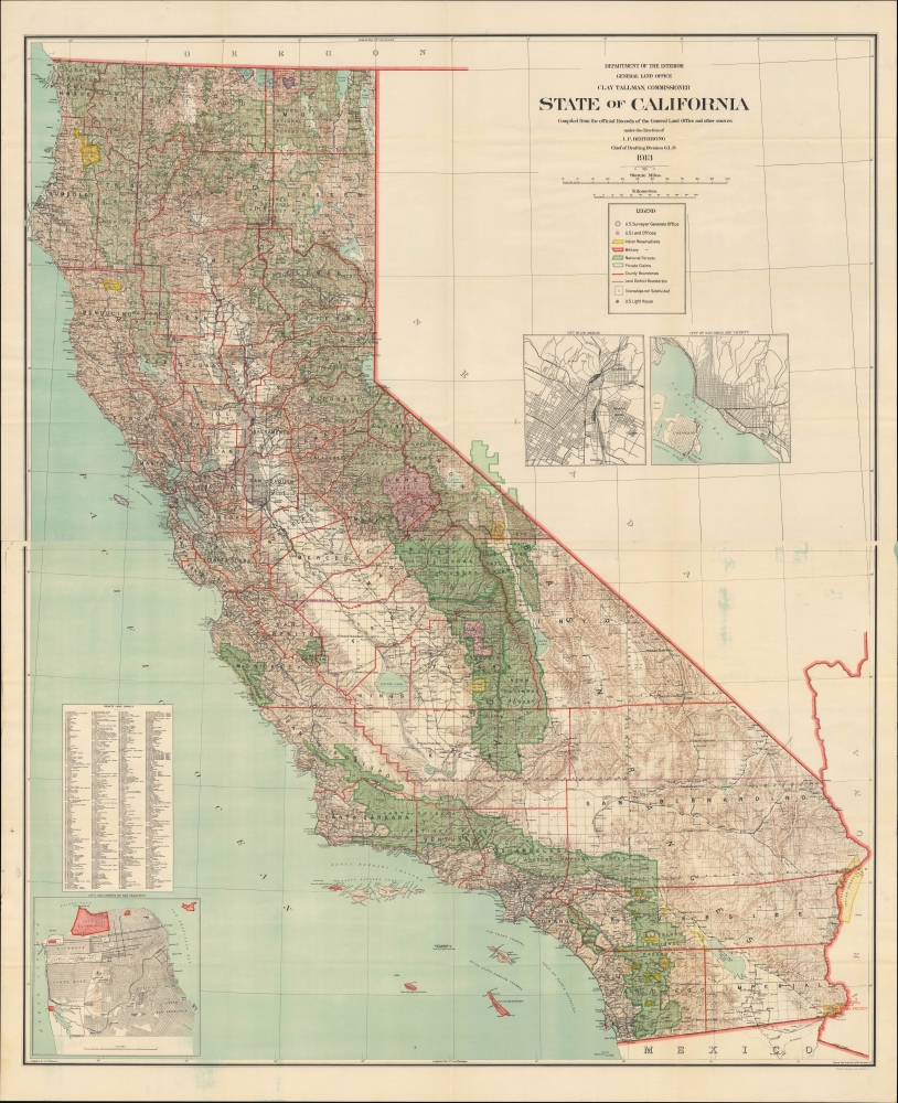
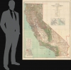
1913 Dinsmore Large Two-Sheet Map of California
California-dinsmore-1913$1,200.00


Title
State of California compiled from the official Records of the General Land Office and other sources.
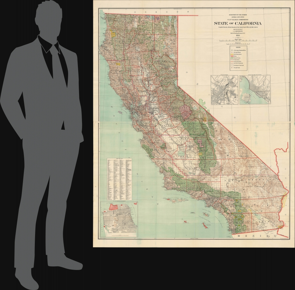
1913 (dated) 58.5 x 47.5 in (148.59 x 120.65 cm) 1 : 760000
1913 (dated) 58.5 x 47.5 in (148.59 x 120.65 cm) 1 : 760000
Description
An epic two-sheet 1913 wall map of California, standing nearly five feet tall, compiled by Andrew Dinsmore of the General Land Office. The map illustrates California's complex interrelations with indigenous peoples and water supply.
There are, however, several larger-scale projects mentioned here which remade the landscape and changed the course of the state's history. Perhaps the most notorious of these is the Los Angeles Aqueduct, which was driven by urban growth rather than farming. Completed the same year as this map's publication, though not indicated here, it largely followed the course of the Southern Pacific line seen here through the Owens River Valley and on to Mojave and the Antelope Valley north of Los Angeles. Drawing on the waterways that fed Mono Lake and Owens Lake, the Aqueduct was a modern engineering marvel, without which the development of Southern California would have been impossible. It was also an ecological disaster, resulting in the desiccation of Owens Lake, with Mono Lake almost suffering the same fate. It was despised by local farmers, whose own water supply was depleted, and the project resulted in one of the worst man-made disasters in U.S. history when St. Francis Dam collapsed in 1928, killing over 400 people.
Also in 1913, the U.S. Congress passed the Raker Act authorizing the city of San Francisco to construct of a dam in the Hetch Hetchy Valley in the northern portion of Yosemite National Park (near Tilden Lake and Richardson Peak). San Francisco's water needs were as dire as Los Angeles', particularly when the existing system proved incapable of providing sufficient water to firefighters during the city's catastrophic earthquake and fire of 1906. Although San Francisco would not receive water from Hetch Hetchy until 1934, the project has remained the basis of the city's water supply ever since.
Around this time, the federal government also began undertaking various dam and irrigation projects in California, through the newly-established Bureau of Reclamation (the Reclamation Act, which created the Bureau, was primarily meant to irrigate the Western U.S. for agricultural purposes). The Orland Project on the border of Glenn and Tehama Counties, meant to provide and control water for agricultural purposes, is the oldest Federal irrigation project in California. The Klamath Project in the far north of the state, spanning the border with Oregon, resulted in several dams being built across the namesake river to generate power for the California-Oregon Power Company. The river and its salmon are critical to the culture, identity, and economy of several Native Tribes and the construction of the dams seriously disrupted these traditions. Several of the dams have since become inefficient or redundant, and four of the six dams across the river are currently in the process of being removed, the largest dam removal project in the world, which should return much of the river to its natural flow, reviving salmon populations in the process.
The Yuma Project in the state's southeastern corner was the first dam and reclamation project on the Colorado River. White settlers had flooded into the arid lands of southeastern California in the late 19th century, resulting in the creation of Imperial County (California's most recent) in 1907. But their irrigation methods were insufficient to support a farming economy in a desert. In order to do so, the federal government turned over the entire (Fort) Yuma Indian Reserve to the Bureau of Reclamation. To 'tame' the famously tempestuous Colorado River and 'make the desert bloom,' multiple dams and canals were built in both Arizona and California. The most ambitious was the Colorado River Aqueduct, meant to supplement the already overtaxed Los Angeles Aqueduct and provide additional water to the growing metropolis.
A Closer Look
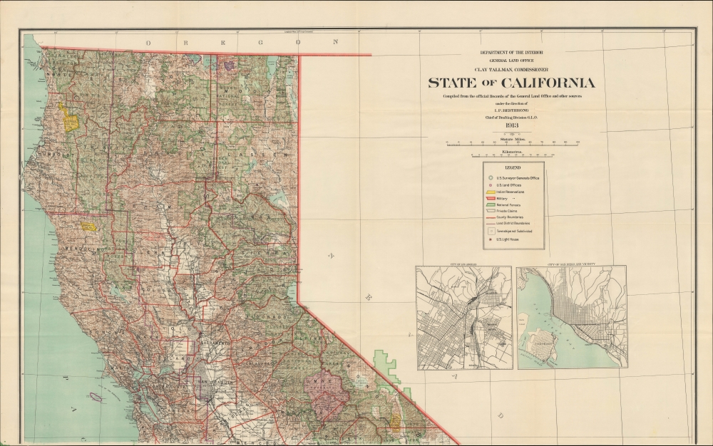
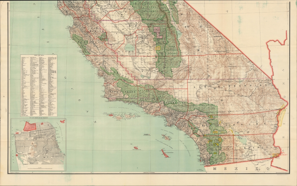
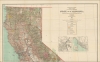
Depicting the state in granular detail, the map employs vivid chromolithographic coloring to indicate terrain and distinguish national parks, national forests, national monuments, and Indian Reservations. Private land claims, some dating back to the ranchos of the Spanish and Mexican era, are listed in an index at left. Lighthouses, U.S. military land, U.S. Surveyor and Land Office locations, survey lines, and railways (including interurban light rail in Southern California) are noted throughout. Inset maps of Los Angeles, San Diego, and San Francisco are also provided.'Homeless Indians'
The Indian Reservations indicated here do not include the relatively small Rancherías established in California around this time. A unique California institution, Rancherías were meant to provide tracts of land to 'homeless' Indians who had been displaced by white settlers. Often, these communities were established in the late 19th century near the edge of settler communities. The Rancherías were a means of formalizing and securing rights to lands they already resided on. But the wider issue of 'homeless' Indians is referred to here, for example at the 'Homeless Paiute and Other Indians' reservation north of Bishop. In the early 1930s, the vast majority of this reservation was eliminated to allow for water to be piped southwards to Los Angeles, demonstrating the interaction between the demand for water, displacement of Native peoples, and the American settlement of California.California's Water Wars
California was growing quickly at this time; the state's population doubled between 1900 and 1920. Many of the new arrivals were farmers, who realized that the state's immense size, prodigious sunshine, and suitable soils, if coupled with a regular and reliable water supply, could produce an almost limitless amount of agricultural goods. Historically a vast wetlands, the groundwater of the Central Valley was so thoroughly overpumped that the ground sank several feet and additional water was needed to maintain the growing agricultural industry. Eventually, both the state and federal government undertook massive engineering projects to irrigate the Central Valley, but at the time of this map's publication, these efforts were more haphazard and experimental, and many dams that did exist were privately constructed.There are, however, several larger-scale projects mentioned here which remade the landscape and changed the course of the state's history. Perhaps the most notorious of these is the Los Angeles Aqueduct, which was driven by urban growth rather than farming. Completed the same year as this map's publication, though not indicated here, it largely followed the course of the Southern Pacific line seen here through the Owens River Valley and on to Mojave and the Antelope Valley north of Los Angeles. Drawing on the waterways that fed Mono Lake and Owens Lake, the Aqueduct was a modern engineering marvel, without which the development of Southern California would have been impossible. It was also an ecological disaster, resulting in the desiccation of Owens Lake, with Mono Lake almost suffering the same fate. It was despised by local farmers, whose own water supply was depleted, and the project resulted in one of the worst man-made disasters in U.S. history when St. Francis Dam collapsed in 1928, killing over 400 people.
Also in 1913, the U.S. Congress passed the Raker Act authorizing the city of San Francisco to construct of a dam in the Hetch Hetchy Valley in the northern portion of Yosemite National Park (near Tilden Lake and Richardson Peak). San Francisco's water needs were as dire as Los Angeles', particularly when the existing system proved incapable of providing sufficient water to firefighters during the city's catastrophic earthquake and fire of 1906. Although San Francisco would not receive water from Hetch Hetchy until 1934, the project has remained the basis of the city's water supply ever since.
Around this time, the federal government also began undertaking various dam and irrigation projects in California, through the newly-established Bureau of Reclamation (the Reclamation Act, which created the Bureau, was primarily meant to irrigate the Western U.S. for agricultural purposes). The Orland Project on the border of Glenn and Tehama Counties, meant to provide and control water for agricultural purposes, is the oldest Federal irrigation project in California. The Klamath Project in the far north of the state, spanning the border with Oregon, resulted in several dams being built across the namesake river to generate power for the California-Oregon Power Company. The river and its salmon are critical to the culture, identity, and economy of several Native Tribes and the construction of the dams seriously disrupted these traditions. Several of the dams have since become inefficient or redundant, and four of the six dams across the river are currently in the process of being removed, the largest dam removal project in the world, which should return much of the river to its natural flow, reviving salmon populations in the process.
The Yuma Project in the state's southeastern corner was the first dam and reclamation project on the Colorado River. White settlers had flooded into the arid lands of southeastern California in the late 19th century, resulting in the creation of Imperial County (California's most recent) in 1907. But their irrigation methods were insufficient to support a farming economy in a desert. In order to do so, the federal government turned over the entire (Fort) Yuma Indian Reserve to the Bureau of Reclamation. To 'tame' the famously tempestuous Colorado River and 'make the desert bloom,' multiple dams and canals were built in both Arizona and California. The most ambitious was the Colorado River Aqueduct, meant to supplement the already overtaxed Los Angeles Aqueduct and provide additional water to the growing metropolis.
Publication History and Census
This map was compiled by Andrew Dinsmore, with tracing and lettering by William Bauman, Jr., both of the General Land Office. It was printed by Eckert Lithographing Co. in Washington, D.C. in 1913. The G.L.O. produced this large two-sheet map of California in multiple editions in the late 19th and early 20th centuries. The present edition is listed among the holdings of eleven institutions in the OCLC, as well as the American Geographical Society Library at the University of Wisconsin Milwaukee. Regardless of edition, this map is scarce to the market.CartographerS
Andrew F. Dinsmore (1843 - 1925) was a draughtsman and cartographer who worked for the U.S. Government's General Land Office, working his way up to Principal Draughtsman by the early 20th century. As a result, he was involved in the production of many of the G.L.O.'s hallmark maps of the late 19th and early 20th century. Dinsmore was born in Michigan and served in the U.S. Civil War, achieving the rank of Corporal (he is buried in Arlington National Cemetery). He looks to have resided in Detroit for a period after the war, but by 1868, he had relocated to Washington, D.C. In city directories, his occupation is listed variously as printer, draughtsman, or government clerk, but at any rate began producing maps for the G.L.O. by 1876 and continued to do so until soon before his death. More by this mapmaker...
Ithamar Parsons Berthrong (February 26, 1853 - July 29, 1936) was an American surveyor, inventor, and draftsman active with the General Land Office of the U.S. Department of the Interior. Berthrong was born in Rochester, New York. He was made chief of the drafting division on March 23 of 1907. He is associated with many of the most important early 20th century maps issued by the GLO, among them, important maps of Arizona, Colorado, Wyoming, Oregon, Washington, and more. Learn More...
William Bauman Jr. (1866 - July 16, 1933) was an American draftsman. Born in Maryland, Bauman Jr. worked for the General Land Office from the 1890s through at least the mid-1920s. He married Cora Walker (March 15, 1868 - January 18, 1904) on September 12, 1899, with whom he had two children. After retiring from the General Land Office (the historical record does not tell us when he retired), he moved to Florida with his second wife, Rosa, and died in Tampa on July 16, 1933. Learn More...
Eckert Lithographing Company (c. 1907 - 1918) was a printer active in Washington D.C. The firm appears to have worked exclusively for the U.S. Government, particularly the General Land Office and the U.S. Geological Survey. Learn More...
Condition
Very good. Light wear along original folds.
References
OCLC 22806806. American Geographical Society Library 813 B-1913a.