Title
California A Map of History / A Guide Map to the Best Pleasures and Treasures.
1954 (dated)
26.75 x 21 in (67.945 x 53.34 cm)
1 : 1865000
Description
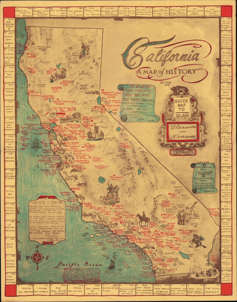
A scarce and charming 1954 historical pictorial map of California by Garner Parker Dicus and Bea Dicus, geared towards tourists and visitors. It cleverly doubles as a promotional map for inns, hotels, restaurants, cafes, taverns, resorts, and more.
A Closer Look
Covering the Golden State, with portions of Nevada and Arizona, the map notes the locations of major natural features (mountains, lakes, rivers), national parks, the historic 'mother lode' gold mining region, and other features, collected under the title 'pleasure and treasure places.' Text and squares in red mark accommodations and dining establishments. It emphasizes historically or architecturally significant sites, including ranchos, the Furnace Creek Inn in Death Valley, the Hollywood Roosevelt Hotel, and the De Anza Hotel in San Jose. Illustrations across the map depict important figures and scenes in California's history, including Native Americans, Catholic missions, gold miners, and pioneer settlers. 57 sites are labeled with a number corresponding with an explanation and date on a border. These range from well-known events, including the founding date of Catholic missions and the 1846 Bear Flag Revolt, to more obscure episodes, such as the pre-Gold Rush discovery of gold in Placerita Canyon in the Santa Clarita Valley and the founding of the State Library in 1850.
This map is a curious production. It combines elements of a historical map, promotional map, and tourist map. It covers the long history of California while also touting contemporary (c. 1954) businesses, which the cartographers assure us they have visited. The state's official tourist offices appear to have not been involved in the map's production, but Dicus enjoins visitors to drive carefully and obey the law, as in official publications. Even the style is somewhat enigmatic; though lithographed, it appears at a glance to be a manuscript map, with the blue-shaded areas resembling crayon.Publication History and Census
This map was drawn by Garner Parker Dicus, with Bea Dicus also noted as a cartographer in the note at left, in 1950, coinciding with the state centennial. However, the red text at the bottom towards the left (under 'Pacific Ocean') is dated 1954, suggesting a later printing. Regardless of printing, the map is quite scarce, with an example dated 1954 noted among the holdings of the University of Wisconsin Milwaukee, while examples dated 1950 (perhaps erroneously) are held by the California State Library, the Library of Congress, and the Bibliothèque nationale de France. An example dated 1960 is held by the University of British Columbia.
Cartographer
Garner Parker Dicus (January 10, 1921 - December 21, 1999) was born in Pocahontas, Iowa. He served in the U.S. Navy during World War II and made a handful of pictorial maps of the United States in the 1950s. He married Bernice Rosetta Cook (May 1, 1908 - February 18, 2003) in 1945 and the couple divorced in 1966 or 1967. He died in Fontana, California on December 21, 1999. More by this mapmaker...
Condition
Very good. Printed. Light wear along original folds. Mild worming loss at fold junction just north of center. Several small tears around border professionally repaired.
References
OCLC 754110751, 494571924, 878156471.