This item has been sold, but you can get on the Waitlist to be notified if another example becomes available, or purchase a digital scan.
1863 Public Survey Map of California
CaliforniaNevada-pubicsurvey-1863$325.00

Title
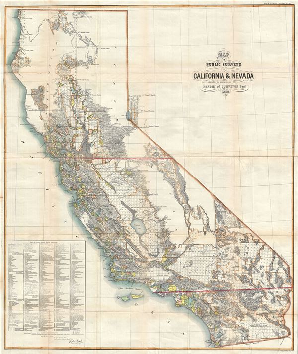
Map of Public Surveys in California and Nevada to accompany Report of Sureyor Genl. 1863.
1863 (dated) 36 x 31 in (91.44 x 78.74 cm) 1 : 1140480
1863 (dated) 36 x 31 in (91.44 x 78.74 cm) 1 : 1140480
Description
An attractive and uncommon map of California and parts of Nevada issued by the Surveyor General in 1863. The map covers all of California as well as the western parts of Nevada near Lake Tahoe and Carson City. Remarkably, a list of 438 'Private Grants Finally Surveyed' appearing in the lower left quadrant numerically identifies corresponding colored zones on the map proper. These refer to Spanish-Mexican land grants throughout California of which this is most likely to be the earliest map to specifically detail. The present map is intended by the U.S. Government to certify and formally recognize these grants, including lands granted to the Church around the various missions as well as private grants. Other surveyed lands are highlighted in orange while unsurveyed lands are left uncolored. The massive Tulare Lake is noted, once the largest freshwater lake in North America, practically a sea, which has since been drained for irrigation purposes. Throughout topography is rendered in hachure. The Land Office Survey Department issued this map in 11 editions from 1854 to 1864, this being the 10 and thus one of the most advanced, issues. Compiled by E.F. Beale, Surveyor General, and engraved and lithographed by Joseph Bien of 24 Vesey Street, New York.
CartographerS
The General Land Office (1812 - 1946) was an independent agency charged with the administration and sale of public lands of the western territories of the United States under the Preemption Act of 1841 and the Homestead Act of 1862. During a time of frenetic energy and rapid westward expansion, the Land Office oversaw the surveying, platting, mapping and eventually the sale of much of the Western United States and Florida. The structural layout of the western United States that we see today, and many of their district and county divisions, are direct result of the early surveying work of the General Land Office. More importantly, as a branch of the Federal Government in Washington D.C. and the only agency able to legally sell and administer public lands in the western territories of the United States, the General Land Office played a pivotal role in consolidating power away from the original states and into the hands of the centralized federal government. The General Land Office was absorbed into the Department of Interior in 1849 and in 1946 merged with the United States Grazing Service to become the Bureau of Land Management. Today the Bureau of Land Management administers the roughly 246 million acres of public land remaining under federal ownership. More by this mapmaker...
Julius (Julien) Bien (September 27, 1826 - December 21, 1909) was a German-Jewish lithographer and engraver based in New York City. Bien was born in Naumburg, Germany. He was educated at the Academy of Fine Arts, Cassell and at Städel's Institute, Frankfurt-am-Main. Following the suppression of the anti-autocratic German Revolutions of 1848, Bien, who participated in the pan-German movement, found himself out of favor in his home country and joined the mass German immigration to the United States. Bien can be found in New York as early as 1849. He established the New York Lithographing, Engraving & Printing Company in New York that focused on the emergent chromo-lithograph process - a method of printing color using lithographic plates. His work drew the attention of the U.S. Government Printing Office which contracted him to produce countless government maps and surveys, including the Pacific Railroad Surveys, the census, numerous coast surveys, and various maps relating to the American Civil War. Bien also issued several atlases both privately and in conjunction with a relation, Joseph Bien. At the height of his career Bien was elected president of the American Lithographers Association. After his death in 1909, Bien's firm was taken over by his son who promptly ran it into insolvency. The firm was sold to Sheldon Franklin, who, as part of the deal, retained the right to publish under the Julius Bien imprint. In addition to his work as a printer, Bien was active in the New York German Jewish community. He was director of the New York Hebrew Technical Institute, the New York Hebrew Orphan Asylum, and president of the B'nai B'rith Order. Learn More...
Source
Annual Report of the Surveyor General, 38th Congress, 1st Session, 1863 (Washington) 1863.
Condition
Very good. Backed on archival tissue for stability. Some toning on original fold lines and wear at fold intersections.
References
Rumsey 1073.010. Wheat, Carl Irving, Mapping of the Transmississippi West, 1540-1861, 1050 (1862).