This item has been sold, but you can get on the Waitlist to be notified if another example becomes available, or purchase a digital scan.
1860s Manuscript Map of the Civil War Battle of Camp Allegheny, West Virginia
CampAlleghanyManuscript-unknown-1862$1,250.00

Title
A Hand sketch of Camp Allegheny from memory.
1862 (undated) 10 x 8 in (25.4 x 20.32 cm)
1862 (undated) 10 x 8 in (25.4 x 20.32 cm)
Description
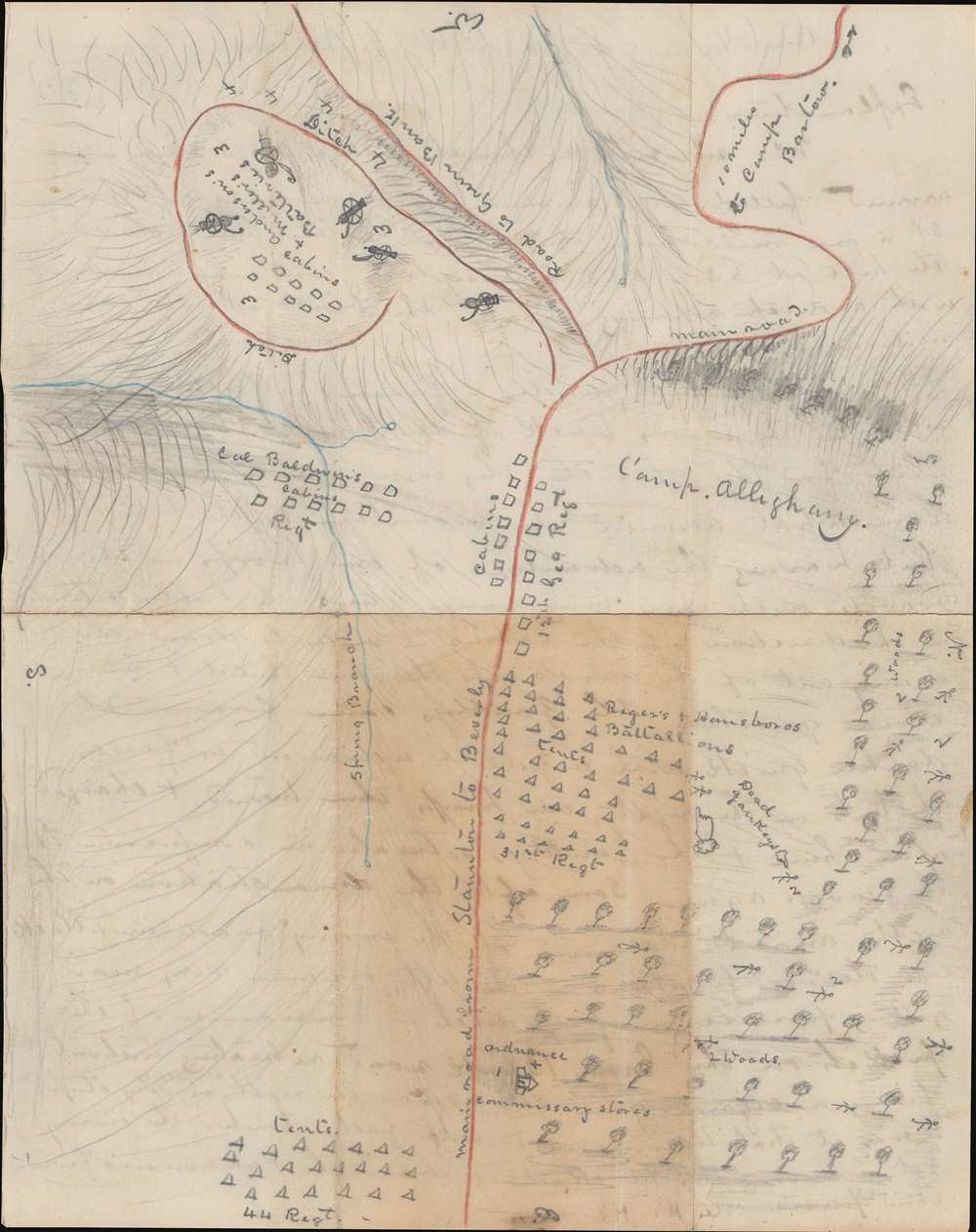
This is a one-of-a-kind Confederate-drawn manuscript map of the Battle of Camp Allegheny, Pocahontas County, West Virginia, fought on December 13, 1861, early in the American Civil War (1861 - 1865). The map's creator, likely the Confederate officer Thomas Ranson, labels the encampment of the 44th Regiment, the 31st (Virginia) Regiment, and cabins occupied by the 12th Georgia Regiment, and Col. Baldwin's Regiment (the 52nd Virginia Regiment - the likely map creator's unit). Artillery batteries commanded by Anderson and Miller are illustrated on top of the knob in the upper right. A church where Confederate ordnance and commissary supplies were stored is illustrated in a copse of trees near the bottom. The initial Union attack came from these trees and the map's creator marks 'dead Yankeys' throughout the woods. The Staunton Pike, which the Confederates were protecting, runs vertically through the map from east to west (with west at top).
Verso Explanation
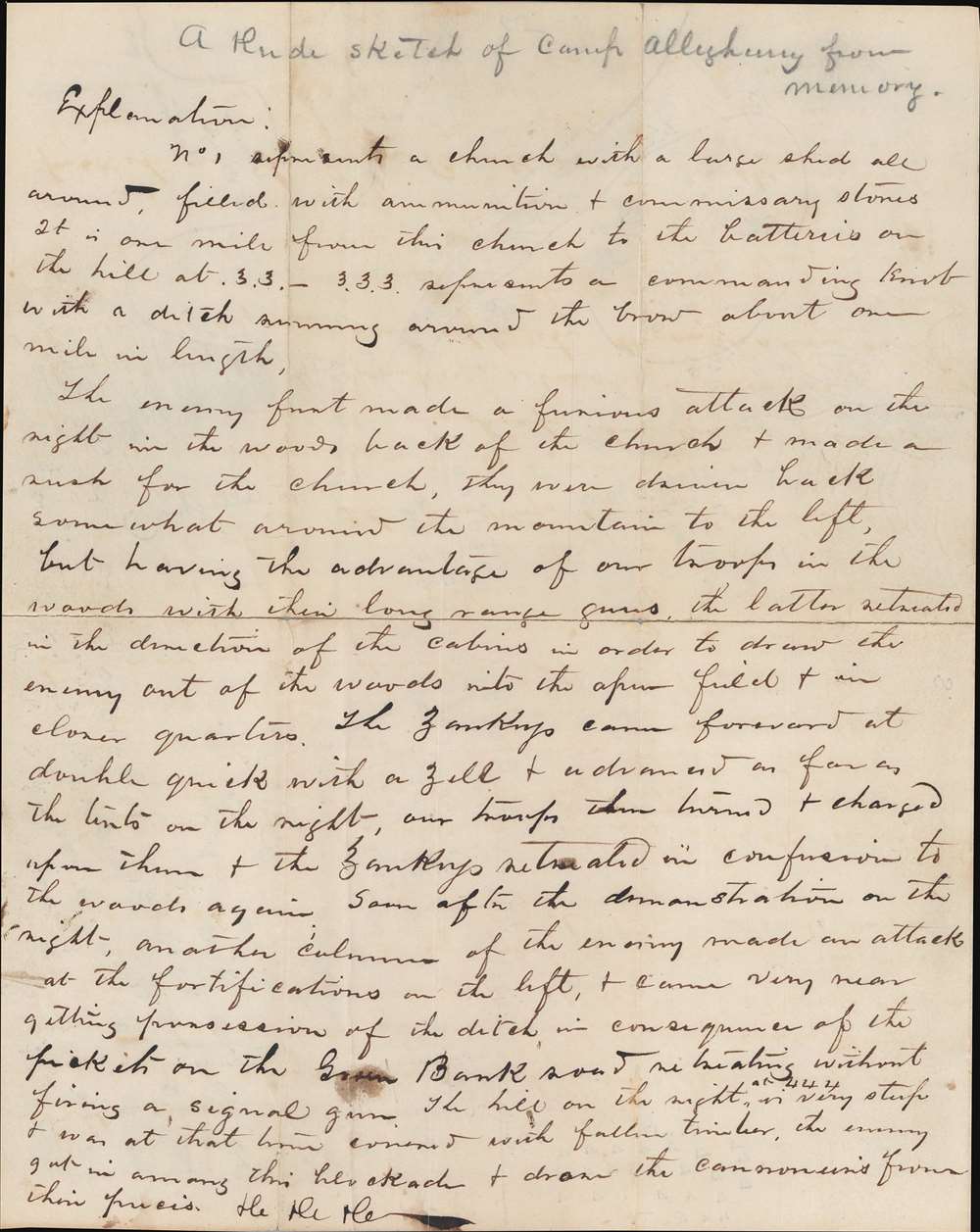
A handwritten explanation of the map occupies the verso. This description reads as follows:Explanation
No. 1 represents a church with a large shed all around, filled with ammunition and commissary stores. It is one mile from this church to the batteries on the hill at .3.3 - 3.3.3. represents a commanding knob with a ditch running around the brow about one mile in length.
The enemy front made a furious attack on the right in the woods back of the church and made a rush for the church. They were driven back somewhat around the mountain to the left, but having the advantage of our troops in the woods with their long range guns the latter retreated in the direction of the cabins in order to draw the enemy out of the woods into the open field and in closer quarters. The Yankeys came forward at double quick with a yell and advance as far as the tents on the right, our troops then turned and charged upon them and the Yankeys retreated in confusion to the woods again. Some after the demonstration on the right, another column of the enemy made an attack at the fortifications on the left, and came very near getting possession of the ditch in consequence of the pickets on the Grain Bank road retreating without firing a signal gun. The hill on the right at .444 is very steep and was at that time covered with fallen timber. The enemy got in among this blockade and drew the cannoners from their pieces. etc. etc. etc.
The Battle of Camp Allegheny
Fought on December 13, 1861, the Battle of Camp Allegheny was a small but bloody battle fought between brigade-level units early in the war - historically overshadowed by larger battles later in the war. Confederate forces were camped on the summit pass of Allegheny Mountain to defend the Staunton and Parkersburg Turnpike (illustrated here in orange). This occupation coincided with a brutal winter and the Confederate troops, who were from Virginia and Georgia, suffered in the cold and often knee-deep snow. Federal troops (which were divided into two columns) attacked the right side of the Confederate camp on the morning of December 13 and engaged for several hours. Not long after the column on the right withdrew, the second column attacked the Confederate left. This lack of coordination (apparently due to difficult terrain) allowed the Confederates to concentrate their forces against both Federal attacks. The battle ended in a Confederate victory, since Union forces retreated, but it was militarily indecisive. It did however, ensure that Highland County would remain in Confederate hands for the time being. Also, the Battle of Camp Allegheny had a direct impact on the future border of West Virginia, with the modern border running along the county line between Pocahontas County and Highland County.The Map's Creator
The individual from whom we acquired this piece claimed that they had bought it from the Ranson family of Appomattox Court House, Virginia. A member of the Ranson family, Thomas Ranson, served in the Confederate Army during the Civil War in the 52nd Virginia Infantry Regiment and likely fought at the Battle of Camp Allegheny. He attained the rank of Captain. In researching Thomas Ranson, we located a Captain Thomas Davis Ranson (May 19, 1843 - July 21, 1918), who was born in Charles Town, Virginia (now Charleston, West Virginia) and died in Staunton, Virginia, where the 52nd Virginia Infantry Regiment was organized. Ranson served in the 52nd Virginia from August 16, 1861, until November 6, 1862, when he resigned after being wounded in the right knee at Cross Keys, Virginia as a 2nd lieutenant. He 'reenlisted' in 1864 and became a member of the Secret Service Department in charge of scouts. He was educated at Washington and Lee University (then called Washington College) before enlisting in the Confederate army and after the war studied law at the University of Virginia, receiving a Bachelor of Laws degree in 1868. He practiced law in Staunton, Virginia until his death.Publication History and Census
This map, both unsigned and undated, was likely drawn sometime in the 1860s by Thomas Ranson, a Confederate soldier in the 52nd Virginia Infantry Regiment. As this is a manuscript piece, this is a one-of-a-kind offering.Condition
Good. Unrepaired fold separations. Manuscript battle and map description on verso.


