1674 Bouttats Map of Crete after Boschini
Candia-bouttats-1674$750.00

Title
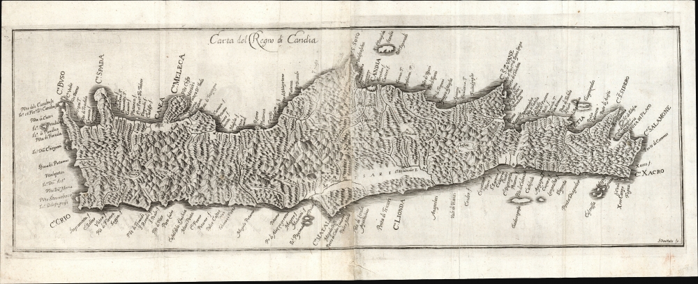
Carta del Regno di Candia.
1674 (undated) 8.75 x 26.5 in (22.225 x 67.31 cm)
1674 (undated) 8.75 x 26.5 in (22.225 x 67.31 cm)
Description
This elegantly engraved, scarce 1674 map of Crete was engraved in Vienna by Gaspar Bouttats after the 1651 map of Marco Boschini. The map captures the island at a crucial historic moment during the Cretan War (1645 - 1669), when the fate of Europe revolved around Crete.
In the words of historian Elizabeth Clutton,
The State of the Art
In following Boschini, the map shares the lineage of Francesco Basilicata, who, between 1610 and 1640, produced the state-of-the-art firsthand mapping of the island. Bouttats produced this, among an array of other maps, for the history of the reign (to date) of Holy Roman Emperor Leopold I (1640 - 1705) written by Galeazzo Gualdo Priorato (1606 - 1678). During this period, Crete was the central feature of the long war between the Republic of Venice and the Ottoman Empire. The concern of the Habsburg Holy Roman Empire was that should peace be found between the two belligerents, the Ottoman Empire would then be free to concentrate on Hungary and Transylvania, where Leopold had enjoyed success against the Ottomans. The war's outcome was of deep concern to the powers of Europe, who had long feared Ottoman and Islamic incursion.In the words of historian Elizabeth Clutton,
At that time, the attention not only of Venice but of the whole of Christian Europe was focused upon the fate of Crete. It was the perfect moment for a patriotic Venetian to affirm the greatness of Venice in her struggle against la potenza vastissima Othomana and, at the same time, to launch a money-making venture by publishing a volume containing maps, plans and drawings of Crete.
Publication History and Census
This map was engraved by Bouttats for inclusion in the 1674 third volume of Galeazzo Gualdo Priorarto's Historia di Leopoldo Cesare. The history is well represented in institutional collections, but we see only one example of the separate map in OCLC, held by Princeton University.CartographerS
Gaspar Bouttats (1634 - ????) was an engraver and artist in Vienna, Austria. He produced a number of maps for a variety of publishers there. Not to be mistaken for the Flemish engraver of the same period. More by this mapmaker...
Marco Boschini (1602 - 1681) was an Italian baroque period painter, engraver, art dealer, and writer active in Venice. Boschini was born in Venice and educated at Palma il Giovane. While Boschini's paintings are today well known, at the time he was primarily an art dealer whose clients included Cardinal Leopoldo de'Medici. In cartographic circles, he is best known for his work on Crete, including a book at least 3 significant maps, all of which were derived from the manuscript maps of Francesco Basilicata. Learn More...
Francesco Basilicata (???? – c. 1640) was a 17th century Italian cartographer and military engineer. Basilicata worked in the service of the Republic of Venice and is known for his maps and drawings of the island of Crete. Little is known of his early life, but it has been suggested that he may have been from Palermo. He lived in Crete during the first two decades of 17th century, in the last days of Venetian hegemony over the island. Basilicata fell in love with the island's rugged scenery and spent the years between 1612 and 1629 meticulously mapping the entire island. His maps of Crete from the foundation for must subsequent maps until the early 18th century. Learn More...
Source
Priorato, Galeazzo Gualdo, Historia di Leopoldo Cesare, (Vienna: Hacque) 1674.
Condition
Very good. Printed to two sheets and joined as bound. Two mends at bottom folds just entering image with no loss to map.
References
OCLC 1104811108. Zacharakis, C. G. A Catalogue of Printed Maps of Greece 1477-1800, 673.