Title
Candia. / Insula Candia olim Creta. N. Visscher exc.
1670 (undated)
15.75 x 20 in (40.005 x 50.8 cm)
1 : 160,000
Description
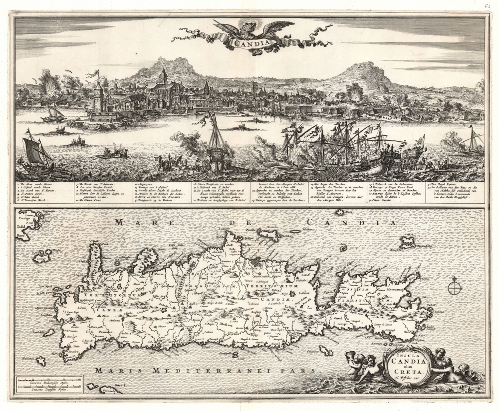
This is Nicolas Visscher's 1670 map of Crete, accompanied by a dramatic panorama of the famous Siege of Candia (Heraklion).
Siege of Candia
The conflict was fought primarily between Venice and the Ottoman Empire during the Great Turkish War but drew in the Knights of Malta, the Papal States, and an array of volunteers and mercenaries, predominantly French. The siege stretched from 1648 to 1669, making it the second-longest siege in history, topped only by the 30-year Siege of Ceuta. Although the siege ended with a Venetian surrender, the crushing cost of undertaking the siege, in both lives and money, was a major contribution to the subsequent decline of the Ottoman Empire.The Panorama
The top of the sheet is dominated by a panoramic view of Heraklion in the midst of struggle. In the foreground, warships battle to control the approaches to the city. In the background, the city and its fortifications are under active bombardment while formations of soldiers array against the Ottoman siege works. The image specifically memorializes 1668 efforts by the Knights of Malta, led by Vincenzo Rospigliosi (1635 - 1673), to break the siege. The effort proved disastrous: in particular, French volunteers launched a solo surprise counterattack on the Ottoman line rather than operate in cohesion with the rest of the force, leading to the loss of nearly 50% of their number. The text pertinent to the action on the view (#20) merely refers to The moat of St. Andre, where the French Volunteers have caused several partial failures. In all, 33 features in the view are numbered and described in a key. In addition to the location of the French debacle, the key notes explosions of Ottoman bombards and mines, important bulwarks (particularly those whose defense was claimed by famous officers), and the ships commanded by Admiral Rospigliosi himself.
The beautifully engraved view is a close copy of one appearing on a 1669 broadsheet engraved by the master Romeyn de Hooghe, retaining virtually all of the details of the original down to the banner cartouche surmounted by the Venetian lion. The major difference between the two is the language of the key: De Hooghe's original is in French, whereas the present iteration is in Dutch.The Map
The lower half of the engraving is a map of Crete, following the work of Georgio Sideri Calapoda (fl. c. 1537 - 1565). Calapoda's model had been the dominant delineation of Crete for a century: it appeared in the works of Ortelius, Mercator, Hondius, Blaeu, Jansson, and De Wit. The primacy of Calapoda's manuscripts was not misplaced: as a resident of Crete, he knew the island and its history well. His model superseded the 1513 Waldseemüller map.The Labyrinth and Other Holes in the Ground
Among the features appearing here is a symbol representing the Labyrinth of Daedalus: the legendary maze built for King Minos to contain the bull-headed Minotaur. While often considered to have been constructed at Knossos, recent archaeology suggests a series of tunnels at Gortyn, which is tantalizingly close to the location of the labyrinth symbol on the Waldseemüller map. This would correspond with Gortyna, the Cretan capital in the 1st century AD. Other archaeological sites of interest appear. Crete's Lassithi Plateau is shown (Lascilo Campo) as well as the Dikti Mountains nearby. Greek mythology identifies this area as the birthplace of Zeus and was said to be the divine lecher's hiding place after his abduction of Europa.
Again, Visscher's engraving sets the present work apart from its precursors: the island is surrounded by elegantly engraved waves, and the title cartouche - framed in a seaweed and shell motif - is suspended in the water by a quintet of sea-putti, one of whom blows a conch.Publication History and Census
This map was engraved for inclusion in Nicolas Visscher's atlases, including his Atlas Minor, Atlas Novus, and Atlas Major. Zacharakis notes the map also appeared in De Jonghe's 1675 work. An early date of 1670 is reasonable. We see 14 examples of the separate sheet in institutional collections, albeit some erroneously dated prior to the events depicted.
Cartographer
Claes Jansz Visscher (1587 - 1652) established the Visscher family publishing firm, which were prominent Dutch map publishers for nearly a century. The Visscher cartographic story beings with Claes Jansz Visscher who established the firm in Amsterdam near the offices of Pieter van den Keer and Jadocus Hondius. Many hypothesize that Visscher may have been one of Hondius's pupils and, under examination, this seems logical. The first Visscher maps appear around 1620 and include numerous individual maps as well as an atlas compiled of maps by various cartographers including Visscher himself. Upon the death of Claes, the firm fell into the hands of his son Nicholas Visscher I (1618 - 1679), who in 1677 received a privilege to publish from the States of Holland and West Friesland. The firm would in turn be passed on to his son, Nicholas Visscher II (1649 - 1702). Visscher II applied for his own privilege, receiving it in 1682. Most of the maps bearing the Visscher imprint were produced by these two men. Many Visscher maps also bear the imprint Piscator (a Latinized version of Visscher) and often feature the image of an elderly fisherman - an allusion to the family name. Upon the death of Nicholas Visscher II, the business was carried on by the widowed Elizabeth Verseyl Visscher (16?? - 1726). After her death, the firm and all of its plates was liquidated to Peter Schenk. More by this mapmaker...
Source
Visscher, N., Atlas Minor, (Amsterdam) c. 1670-1690.
The Visscher family, from Nicolas I onwards, produced atlases under the title of Atlas Minor starting in the early to mid 1670s. These should be considered composite atlases, and they exhibited varying content and generally lackd title page or index. Nicolas I earned the privilege to publish from the States of Holland and West Friesland in 1677, so the presence of the ‘cum priviligeo’ on a map indicates it having been printed after this date. Examples of the Atlas Minor were produced into the early 18th century. Maps without the privilege may have been included in the elder Visscher’s Atlas Contractus, with some appearing in early examples of the Atlas Minor. Many appear to have been separate issues, or to have been added to the atlases of other map makers, primarily Jansson and his heirs.
Condition
Very good. Trimmed to neatline, just touching border, and expertly remargined. Else a very clean example with a bold, sharp strike.
References
OCLC 859141023. Rumsey 11755.112. (1690) Zacharakis, C. G. A Catalogue of Printed Maps of Greece 1477-1800, 3631.