Title
Carte Touristique de Cannes et des environs Massiv de L'Estérel.
1925 (undated)
37.25 x 40.75 in (94.615 x 103.505 cm)
1 : 100000
Description
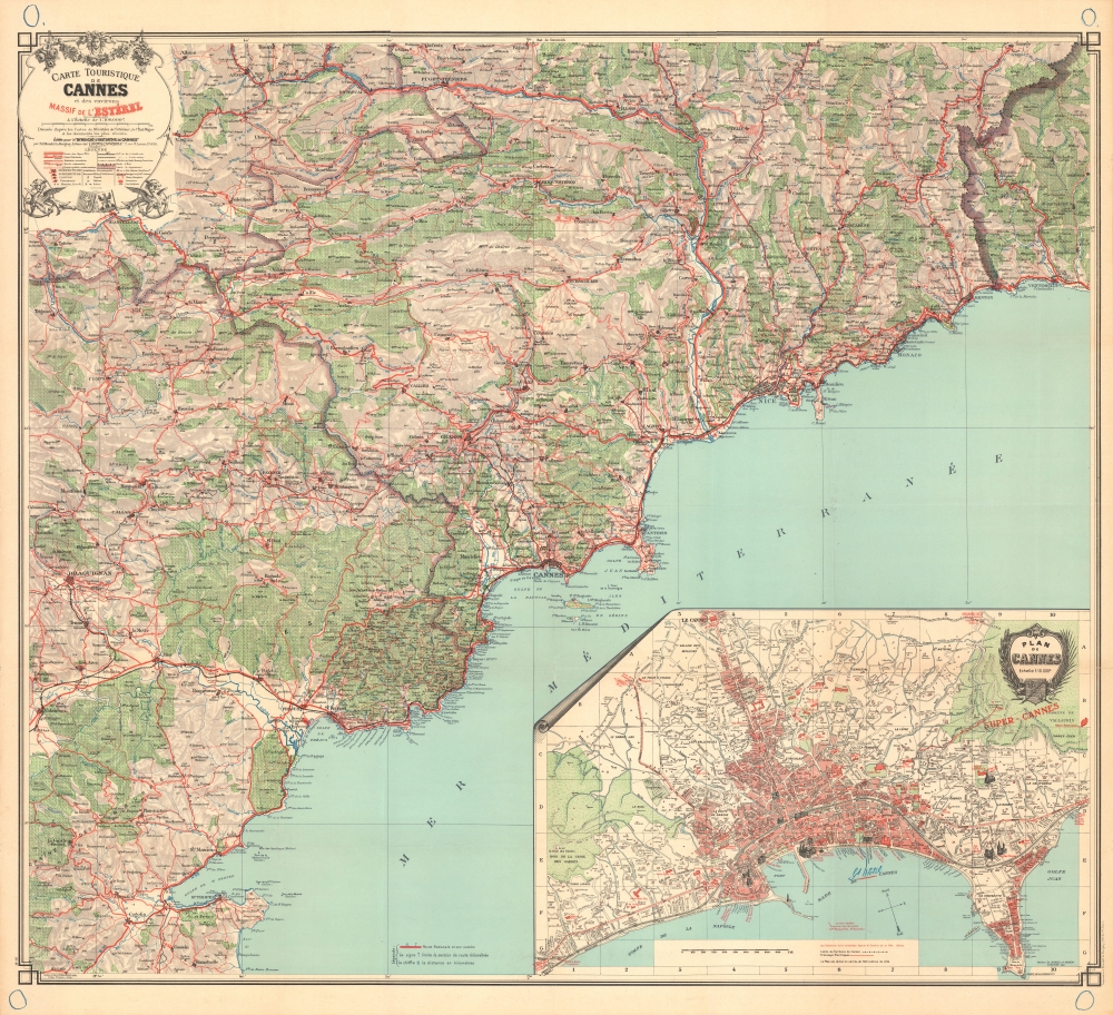
A spectacular c. 1920 large-scale chromolithograph map of the French Riviera by Blondel la Rougery. The map, a lavish production meant to highlight the Cannes region for tourists, was issued as part of the Syndicat d'Initiative de Cannes's ongoing and outrageously successful mission to turn the French Riviera into a playground for the elite. Its issue corresponds with the Rivera's, and specifically Cannes', emergence as a mecca for the intelligentsia, hosting Scott and Zelda Fitzgerald, Pablo Picasso, Francis Picabia, and Jean Cocteau, among countless others.
A Closer Look
The map is drawn on a large scale with coverage embracing the Côte d'Azur from San Tropez to Ventimiglia (IT), including St. Raphaël, Cannes, Nice, Monaco, Monte Carlo, and Menta, along with other smaller cities. Coverage extends inland towards the Alpes-Maritimes, to include the Var River valley as far as, roughly, Puget-Théniers and Annot. The map offers meticulous detail, illustrating roads and other transportation networks, forests, ruins, and mountains with subtle topographical shading. An inset in the lower right details Cannes, with important buildings, particularly hotels, highlighted in red. Monumental structures, including the Casino Municipal, churches, and the railway station, are illustrated pictorially. There is manuscript annotation in blue pencil by a previous owner recording travels through the region.Romanticizing the French Riviera
In the 1920s, Cannes and the French Riviera emerged as glamorous destinations for the international elite, transforming from quaint coastal towns into vibrant hubs of luxury and leisure. The region attracted aristocrats, artists, and Hollywood stars who flocked to its sun-drenched shores, drawn by the stunning Mediterranean landscapes and the burgeoning social scene. Cannes, in particular, became synonymous with opulence, where grand hotels, such as the Carlton and the Martinez, hosted lavish parties and soirées. The French Riviera's allure was further immortalized in the works of authors like F. Scott Fitzgerald, who captured the era's spirit of excess and carefree indulgence, marking the 1920s as a golden age for this enchanting stretch of the French coastline.
Much of the work in romanticizing the French Riviera was accomplished by its stunning natural beauty; the rest can be attributed to the sponsor of this map, the Syndicat d'Initiative de Cannes (SIC; 1894 - present). The SIC played a pivotal role in transforming Cannes into a world-renowned tourist destination. Originally founded to promote Cannes and its surrounding areas, the SIC was part of a broader movement in France aimed at developing local tourism through organized efforts. This organization was responsible for enhancing the city's appeal to visitors by improving infrastructure, promoting cultural events, and offering information services to tourists. The organization's efforts were instrumental in establishing Cannes as a premier destination on the French Riviera, particularly during the Interwar Period. The SIC also contributed to the city's cultural identity by supporting events such as the Cannes Film Festival, which further cemented the city's status as a glamorous and culturally rich location.Chromolithography
Chromolithography, sometimes called oleography, is a color lithographic technique developed in the mid-19th century. The process uses multiple lithographic stones, one for each color, to yield a rich composite effect. Generally, a chromolithograph begins with a black basecoat upon which subsequent colors are layered. Some chromolithographs used 30 or more separate lithographic stones to achieve the desired effect. Chromolithograph color can be blended for even more dramatic results. The process became extremely popular in the late 19th and early 20th centuries when it emerged as the dominant method of color printing. The vivid color chromolithography made it exceptionally effective for advertising and propaganda.Publication History and Census
This map was published c. 1925 by Édouard Blondel la Rougery for the Syndicat d'Initiative de Cannes. Rare. We see just two examples of this map in OCLC, which are part of the collections at the Bibliothèque nationale de France and the Sächsische Landesbibliothek - Staats- und Universitätsbibliothek Dresden.
Cartographer
Blondel la Rougery was a French publishing house founded in Paris around 1902 by the publisher and aerophile Édouard Blondel la Rougery (July 9, 1877 - July 20, 1955). The company specialized in maps and books, particularly those related to aviation and maritime themes. Over time, Blondel la Rougery became well-known for its detailed maps, which were used extensively during both World Wars. In 1934, the firm inherited the aviation and cartographic copyrights of Georges Besançon (1866 - 1934), erstwhile publisher of L'Aérophile. In 1955, his son Max Blondel la Rougery took over the business and continued to manage it until 1976. The company continued to operate until the early 21st century, with its focus remaining largely on map production. The publisher’s works are notable for their precision and artistic quality, making them highly regarded in both historical and cartographic circles. More by this mapmaker...
Condition
Very Good. Some wear and verso reinforcement at original fold intersections and along edges. A few old blue pencil marks related to a voyage - cold be erased.
References
OCLC 494250363, 809057153.