This copy is copyright protected.
Copyright © 2025 Geographicus Rare Antique Maps
Digital Image: 1743 / 1771 Catesby Map of the American Southeast: Florida, Georgia and the Bahamas
CarolinaFlorida-catesby-1743-2_d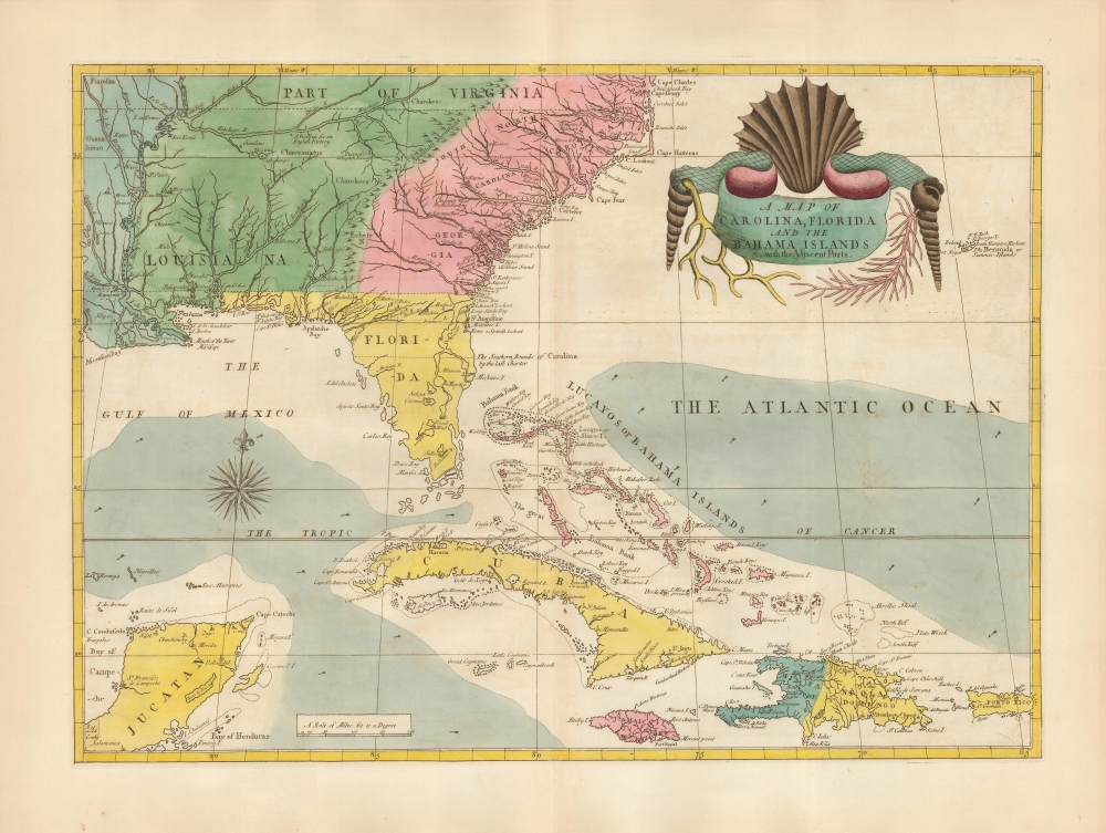

FOR THE ORIGINAL ANTIQUE MAP, WITH HISTORICAL ANALYSIS, CLICK HERE.
Digital Map Information
Geographicus maintains an archive of high-resolution rare map scans. We scan our maps at 300 DPI or higher, with newer images being 600 DPI, (either TIFF or JPEG, depending on when the scan was done) which is most cases in suitable for enlargement and printing.
Delivery
Once you purchase our digital scan service, you will receive a download link via email - usually within seconds. Digital orders are delivered as ZIP files, an industry standard file compression protocol that any computer should be able to unpack. Some of our files are very large, and can take some time to download. Most files are saved into your computer's 'Downloads' folder. All delivery is electronic. No physical product is shipped.
Credit and Scope of Use
You can use your digial image any way you want! Our digital images are unrestricted by copyright and can be used, modified, and published freely. The textual description that accompanies the original antique map is not included in the sale of digital images and remains protected by copyright. That said, we put significant care and effort into scanning and editing these maps, and we’d appreciate a credit when possible. Should you wish to credit us, please use the following credit line:
Courtesy of Geographicus Rare Antique Maps (http://www.geographicus.com).
How Large Can I Print?
In general, at 300 DPI, you should at least be able to double the size of the actual image, more so with our 600 DPI images. So, if the original was 10 x 12 inches, you can print at 20 x 24 inches, without quality loss. If your display requirements can accommodate some loss in image quality, you can make it even larger. That being said, no quality of scan will allow you to blow up at 10 x 12 inch map to wall size without significant quality loss. For more information, it is best consult a printer or reprographics specialist.
Refunds
If the high resolution image you ordered is unavailable, we will fully refund your purchase. Otherwise, digital images scans are a service, not a tangible product, and cannot be returned or refunded once the download link is used.
Mark Catesby (March 24, 1683 - December 23, 1749) was a British artist, scientist, and explorer active in the early to middle parts of the 18th century. He was born at Castle Hedingham, Essex, England, the son of a gentleman farmer and a prominent local politician. John Ray, a famed English naturalist and family, friend inspired Catesby to study natural history. When his father died, in 1712, he accompanied his sister, Elizabeth and her husband William Cooke, a member of the Virginia colony governor’s council, to Virginia. This was his first voyage to the Americas, where he remained for the subsequent 7 years, traveling through Appalachia and to some of the West India Islands, including Jamaica. During his travels he produced meticulous illustrations of the flora and fauna he encountered. On his return to London, the Royal Academy, then headed by Sir Isaac Newton, were so impressed with his work that they raised funds for a second voyage. Catesby returned to the America’s in 1722, arriving in Charleston. In the subsequent 4 years, he traveled throughout the Carolina, Florida, and the Bahamas, observing animal and plant life, and laying the groundwork for his seminal work, The Natural History of Carolina, Florida and the Bahama Islands, considered to be the first fully-illustrated natural history of North America. His work was highly influential, inspiring a new generation of natural historians, including Carl Linnaeus (1707 - 1778) and John James Audubon (1785 - 1851). Catesby died at his home in London where he was buried in the St. Luke Old Street churchyard, aged 66. More by this mapmaker...
Copyright © 2025 Geographicus Rare Antique Maps | Geographicus Rare Antique Maps
This copy is copyright protected.
Copyright © 2025 Geographicus Rare Antique Maps