This copy is copyright protected.
Copyright © 2025 Geographicus Rare Antique Maps
Digital Image: 1735 Homann / Maas Map of the Caspian Sea, Persia, Uzbekistan
CaspianUzbekistan-homannheirs-1735_d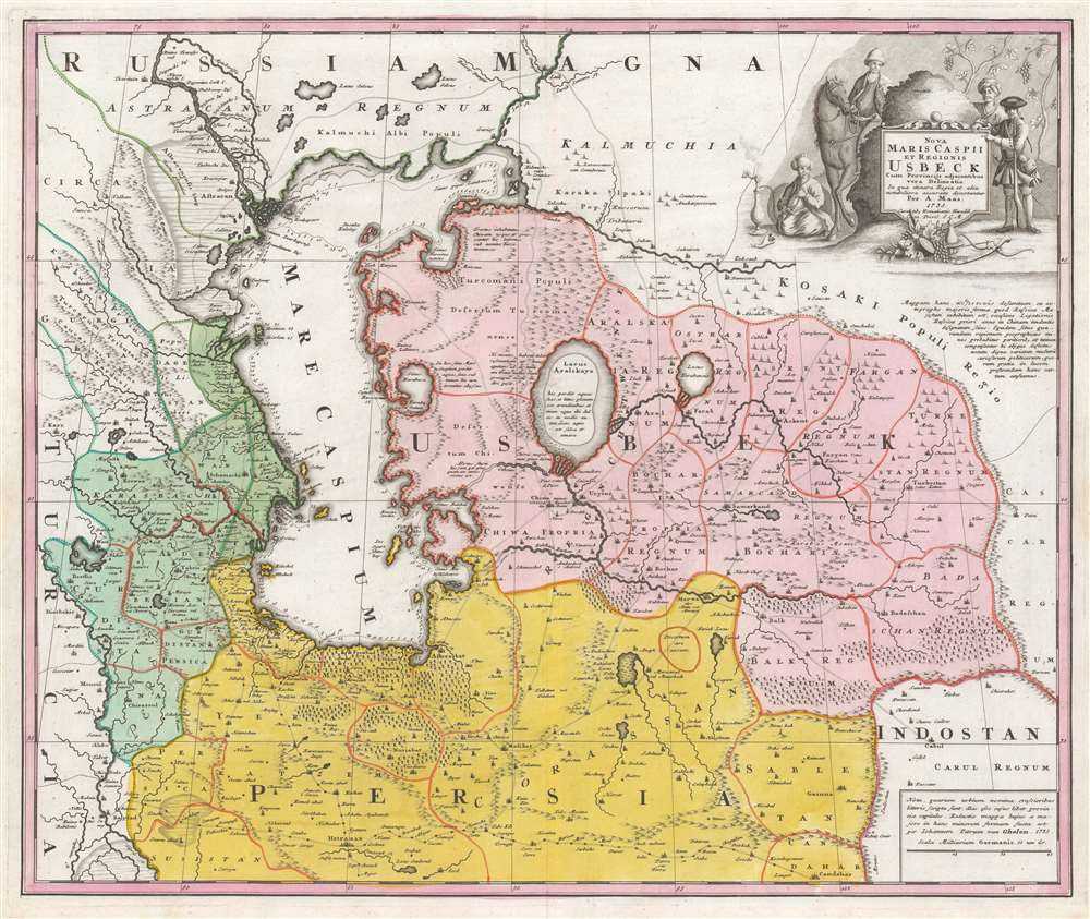

FOR THE ORIGINAL ANTIQUE MAP, WITH HISTORICAL ANALYSIS, CLICK HERE.
Digital Map Information
Geographicus maintains an archive of high-resolution rare map scans. We scan our maps at 300 DPI or higher, with newer images being 600 DPI, (either TIFF or JPEG, depending on when the scan was done) which is most cases in suitable for enlargement and printing.
Delivery
Once you purchase our digital scan service, you will receive a download link via email - usually within seconds. Digital orders are delivered as ZIP files, an industry standard file compression protocol that any computer should be able to unpack. Some of our files are very large, and can take some time to download. Most files are saved into your computer's 'Downloads' folder. All delivery is electronic. No physical product is shipped.
Credit and Scope of Use
You can use your digial image any way you want! Our digital images are unrestricted by copyright and can be used, modified, and published freely. The textual description that accompanies the original antique map is not included in the sale of digital images and remains protected by copyright. That said, we put significant care and effort into scanning and editing these maps, and we’d appreciate a credit when possible. Should you wish to credit us, please use the following credit line:
Courtesy of Geographicus Rare Antique Maps (http://www.geographicus.com).
How Large Can I Print?
In general, at 300 DPI, you should at least be able to double the size of the actual image, more so with our 600 DPI images. So, if the original was 10 x 12 inches, you can print at 20 x 24 inches, without quality loss. If your display requirements can accommodate some loss in image quality, you can make it even larger. That being said, no quality of scan will allow you to blow up at 10 x 12 inch map to wall size without significant quality loss. For more information, it is best consult a printer or reprographics specialist.
Refunds
If the high resolution image you ordered is unavailable, we will fully refund your purchase. Otherwise, digital images scans are a service, not a tangible product, and cannot be returned or refunded once the download link is used.
Homann Heirs (1730 - 1848) were a map publishing house based in Nurenburg, Germany, in the middle to late 18th century. After the great mapmaker Johann Baptist Homann's (1664 - 1724) death in 1724, management of the firm passed to his son Johann Christoph Homann (1703 - 1730). J. C. Homann, perhaps realizing that he would not long survive his father, stipulated in his will that the company would be inherited by his two head managers, Johann Georg Ebersberger (1695 - 1760) and Johann Michael Franz (1700 - 1761), and that it would publish only under the name 'Homann Heirs'. This designation, in various forms (Homannsche Heirs, Heritiers de Homann, Lat Homannianos Herod, Homannschen Erben, etc..) appears on maps from about 1731 onwards. The firm continued to publish maps in ever diminishing quantities until the death of its last owner, Christoph Franz Fembo (1781 - 1848). More by this mapmaker...
Abraham Maas (fl. 1715-1735) was a Dutch cartographer; little is known of his background, but he was among the western European geographers employed at the Russian Academy of Sciences. He is known to have produced maps of the Gulf of Finland (1700), the River Dessekebe (1706), and the first map to apply the name 'Uzbek' geographically, Tabula Nova de Mare Caspium et Usbekorum region.) The latter would provide the basis for Nova Maris Caspii et regionis Usbeck, cum provincijs adjacentibus vera delinetio), reduced by Johann Peter van Ghelen and published by Homanns Heirs in 1735. He also produced a very accurate chart of St. Petersburg in 1734. Learn More...
Johann Peter Van Ghelen (1673-1754) was a Viennese printer, publisher and bookseller; Perhaps in his capacity as Court Printer to the Holy Roman Emperor, he produced several maps and battle plans: among them his,Wahre Abbildung der durch die glorreiche Russische Waffen den 2. Julii 1737 mit Sturm eroberten Festung Oczakoff, the 1738 Plan der Attaque deren Turken den 9. October 1738 auf die Schantz Ratscha, and Attaque deren Wurfen auf die Linie bey Belgrad den 26. September 1738. He also executed the print version of Abraham Maas' Nova Maris Caspii et Regionis Usbeck in 1735. Learn More...
Copyright © 2025 Geographicus Rare Antique Maps | Geographicus Rare Antique Maps
This copy is copyright protected.
Copyright © 2025 Geographicus Rare Antique Maps