Title
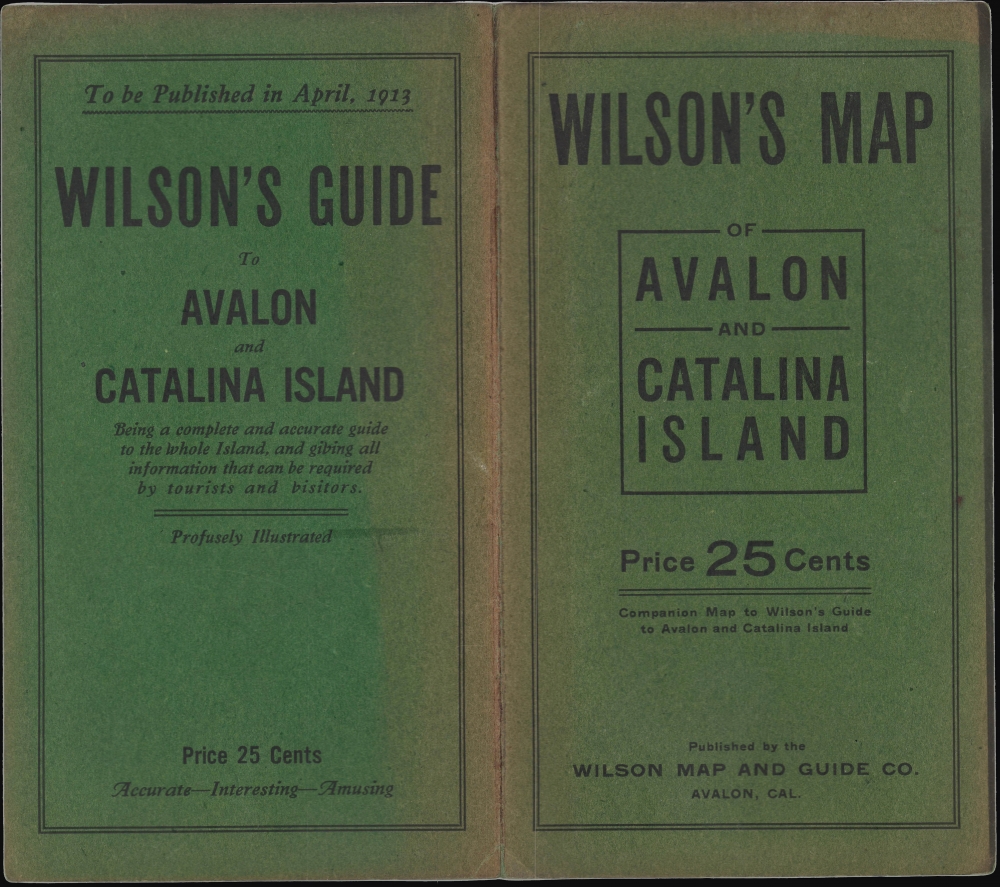
Map of Catalina Island California / Wilson's Map of Avalon and Catalina Island.
1913 (dated)
21.5 x 27.75 in (54.61 x 70.485 cm)
1 : 56000
Description
This is Harry Wilson's rare 1913 map of Avalon and Santa Catalina Island, near Los Angeles, California, published when the island was still in its early days as a weekend destination for Los Angelinos. It also captures the island and Avalon, in particular, on the eve of a devastating 1915 fire that destroyed much of the town.
A Closer Look
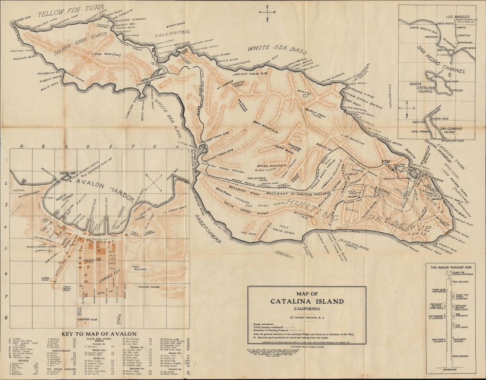
The sheet includes a main topographic map of Catalina Island and three insets, a large one of Avalon at the bottom-left, a smaller inset at the top-right demonstrating the location of the island relative to mainland California and Los Angeles, and an overview of the Avalon 'Pleasure Pier' at bottom-right. The combination of these maps is curious, as the insets provide typical tourist information. In contrast, the large main map, more akin to those used by hikers, encourages exploration of the rugged interior.
The main map traces the island's only coach road and notes various locations, including ranches, canyons, ancient town sites, former pirate coves, beaches, rocks, bays, points, and coves. Offshore, the types of fish that can be caught in each respective area are recorded. The inset of Avalon, oriented towards the northeast, indicates dozens of sites throughout the town, many of which are labeled with a number and listed in an index below, including restaurants, hotels, entertainment venues, and infrastructure. St. John's Chapel, where Wilson served as an Episcopal pastor (see biography below), is at left. The Avalon 'Pleasure Pier,' explained in its own inset at the bottom-right, was where fishing, sightseeing, and recreational boats could be launched, while the Steamer Pier would be the departure and arrival point for ferries. The inset map at the top-right traces ferry routes from the mainland, which were linked to the Pacific Electric Railway, an essential connection with Downtown Los Angeles and the wider Southern California region.Los Angeles' Leisureland
Santa Catalina Island was inhabited by Tongva people, visited by Spanish explorers, Russian traders, pirates, and smugglers, and experienced a brief gold rush in the 1850s. By the late 1850s, Santa Catalina Island was owned by James Lick, the wealthiest man in California, who maintained a small population of ranchers there. In 1887, Lick sold the island to George Shatto, who planned to convert it into a resort for growing Los Angeles. Late in life, before his untimely death in a train crash, Shatto partnered with the Banning brothers, sons of Los Angeles magnate Phineas Banning, and began to develop Santa Catalina. However, after a fire destroyed most of Avalon in 1915, these plans were abandoned and the island was effectively sold to William Wrigley Jr., of chewing gum fame. Wrigley acquired a controlling interest in the Santa Catalina Island Company, which purchased the island in 1919. He invested a fortune to bring Avalon and the rest of the island to fruition as a resort. He opened a casino (that is, a dance hall and theater, not a place of gambling) in the town, sponsored a bird park seen near the center, and designated Catalina as the spring training home of the Chicago Cubs, which he also owned. William's son Philip inherited his control of the Santa Catalina Island Company in 1932 and continued development efforts. Nonetheless, today, most of the island outside of Avalon remains rural and is managed by the Catalina Island Conservancy, a private land trust.Publication History and Census
This map was prepared and published by island resident Rev. Harry Wilson in 1913. It is quite rare, only being noted in the OCLC at the University of California San Diego and the University of Minnesota-Twin Cities. The David Rumsey Historical Map Collection also holds an example.
Cartographer
Harry William Wilson (October 24, 1852 - September 21, 1928) was an Episcopal pastor and map publisher based in Los Angeles. Wilson was born in Banbury, Oxfordshire, England in 1852. He joined received bachelor and master's degrees from Cambridge University (Jesus College) in 1876 and, after briefly serving as an assistant curate, attended the Ely Theological College. He afterwards served as a cleric, ascending through ranks (curate, vicar, rector) in Oxfordshire, Warwickshire, and Middlesex. In 1891, at age 39, he relocated to Mile End in the East End of London and developed a reputation for working among the poor and laboring classes of the city, while also publishing some ten books on religious themes. Wilson married Annette Beatrice Flint in 1903. By 1906, the couple had relocated to the United States, with Wilson taking a clerical position in Milwaukee, Wisconsin. By 1909, they had moved again to Los Angeles, settling in South Pasadena. Rev. Wilson became a well-known figure in religious circles, namely as a representative of Anglo-Catholicism, and served as editor of the publication American Catholic. In 1911, Mr. and Mrs. Wilson moved again, this time to Avalon on Santa Catalina Island. While on Catalina, in addition to serving as pastor at St. John's Episcopal Church (which, like much of Avalon, burned down in a fire in 1915), Wilson published a separate-issue map (Wilson's Map of Avalon and Catalina Island1913) and guidebook (Wilson's Guide to Avalon, 1913 and 1914 editions) of Catalina Island that were among the first available for the soon-to-be major tourist destination. By late 1913, the Wilsons had returned to the mainland and Rev. Wilson took up clerical duties at St. Mattias Church in the Pico-Union neighborhood. In 1917, Wilson gave up editorship of the American Catholic and 'went over' to Roman Catholicism, a shocking move to the journal's readers and the local Episcopal community. Afterwards, Wilson continued to write and published regularly, especially in The Tidings, the official newspaper of the Roman Catholic Archdiocese of Los Angeles. He also established the Harry Wilson Magazine Agency to distribute Catholic publications. The last years of Wilson's life are a mystery; his writing dropped off and although his death is noted in official records, it seems no obituaries were published. More by this mapmaker...
Condition
Good. Wear and toning along fold lines. Accompanied by original cover.
References
Rumsey 16028.002. OCLC 36941018.