
This copy is copyright protected.
Copyright © 2025 Geographicus Rare Antique Maps
Digital Image: 1875 Smith Map of the Centennial Exposition, Philadelphia, Pennsylvania
CentennialGrounds-crawfordsmith-1875_d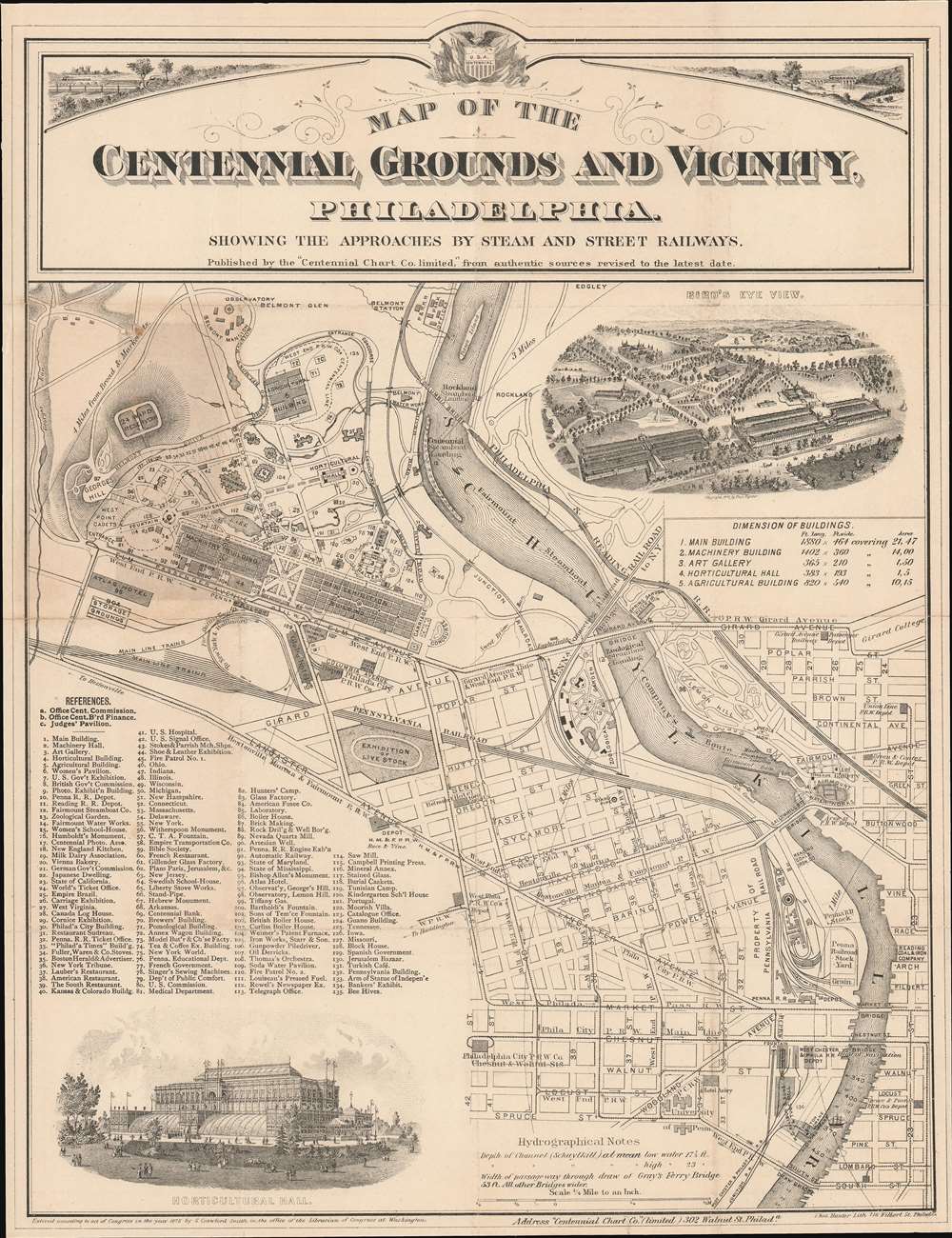

FOR THE ORIGINAL ANTIQUE MAP, WITH HISTORICAL ANALYSIS, CLICK HERE.
Digital Map Information
Geographicus maintains an archive of high-resolution rare map scans. We scan our maps at 300 DPI or higher, with newer images being 600 DPI, (either TIFF or JPEG, depending on when the scan was done) which is most cases in suitable for enlargement and printing.
Delivery
Once you purchase our digital scan service, you will receive a download link via email - usually within seconds. Digital orders are delivered as ZIP files, an industry standard file compression protocol that any computer should be able to unpack. Some of our files are very large, and can take some time to download. Most files are saved into your computer's 'Downloads' folder. All delivery is electronic. No physical product is shipped.
Credit and Scope of Use
You can use your digial image any way you want! Our digital images are unrestricted by copyright and can be used, modified, and published freely. The textual description that accompanies the original antique map is not included in the sale of digital images and remains protected by copyright. That said, we put significant care and effort into scanning and editing these maps, and we’d appreciate a credit when possible. Should you wish to credit us, please use the following credit line:
Courtesy of Geographicus Rare Antique Maps (http://www.geographicus.com).
How Large Can I Print?
In general, at 300 DPI, you should at least be able to double the size of the actual image, more so with our 600 DPI images. So, if the original was 10 x 12 inches, you can print at 20 x 24 inches, without quality loss. If your display requirements can accommodate some loss in image quality, you can make it even larger. That being said, no quality of scan will allow you to blow up at 10 x 12 inch map to wall size without significant quality loss. For more information, it is best consult a printer or reprographics specialist.
Refunds
If the high resolution image you ordered is unavailable, we will fully refund your purchase. Otherwise, digital images scans are a service, not a tangible product, and cannot be returned or refunded once the download link is used.
Samuel Crawford Smith (August 28, 1838 - August 8, 1916) was an American civil engineer and draftsman. Born in Newark, New Jersey to English and Welsh immigrants, Smith served as a captain and then a brevet colonel in the first independent engineering corps of Pennsylvania during the American Civil War. He served with distinction and was stationed on the Potomac with headquarters at Harper's Ferry and on the Monongehela at Grafton and Fairmount. While at Harper's Ferry, just prior to the Battle of Gettysburg, Smith built a pontoon bridge in eight hours that allowed Union General Meade's army to cross the river. He also built and maintained a bridge at Fairmount, Virginia, which protected that city from a Confederate attack. After the war, Smith continued his career in civil engineering and was connected with the Survey Bureau of the City of Philadelphia for thirty years. He also worked as a surveyor for the city of Harrisburg and served as the chief of the Bureau of Statistics of the State of Pennsylvania for a number of years. He also played a prominent role in the early days of railroading in Pennsylvania. In September 1882, Smith was appointed draughtsman in the Department of Internal Affairs in Harrisburg. He also served as Superintendent and Chief Engineer of the Schuylkill Navigation Company for many years. Notably, he lost a contest seeing who could write 'Grand Union Baking Powder. Eight tickets with each pound', after his card was disqualified for being printed instead of handwritten. He managed to fit the sentence on the card 558 times. The contest winner wrote managed to write that sentence on their postcard 271 times. Smith died in Philadelphia on August 8, 1916, of a cerebral hemorrhage. He married Clarinda Boydston, known as Clara, at some point after the American Civil War with whom he had had three sons and a daughter. More by this mapmaker...
Thomas Hunter (c. 1827 - December 24, 1898) was an Irish-American lithographer active in Philadelphia from around 1868 until at least 1894. Born in Ireland,\ Hunter immigrated to the United States in 1831 and lived in Philadelphia with his parents and American-born siblings. He appears as a printer in the 1860 census and was working with Stephen C. Duval, son of P.S. Duval, in the firm Duval and Hunter by 1868 or 1869. The firm's reputation grew in prestige. Hunter assumed sole ownership of the lithographic firm in 1874 and in 1876 was named one of the Philadelphia publishers authorized to publish views the 1876 Centennial Exhibition. Over the course of the late 1870s and the early 1880s, Hunter's firm began to accrue incredible amounts of debt. Hunter turned over management of the firm to William H. Butler at some point in the early 1880s, and in January 1886, the establishment suffered a business-ending fire. By that point, Butler had paid off nearly 2/3 of the remaining debt. It is unclear if Thomas Hunter died on December 24, 1898 or not. We have found a death certificate with this date and a correspondingly close birth date in Ancestry.com records, but there is also an entry in the 1900 Census for a Thomas Hunter who was born in Ireland and living as an inmate in an almshouse. Learn More...
Copyright © 2025 Geographicus Rare Antique Maps | Geographicus Rare Antique Maps
This copy is copyright protected.
Copyright © 2025 Geographicus Rare Antique Maps