This item has been sold, but you can get on the Waitlist to be notified if another example becomes available, or purchase a digital scan.
1905 Merzbacher Map of Western China and Kyrgyzstan: Tian Shan Mountains
CentralTianShan-merzbacher-1905$425.00

Title
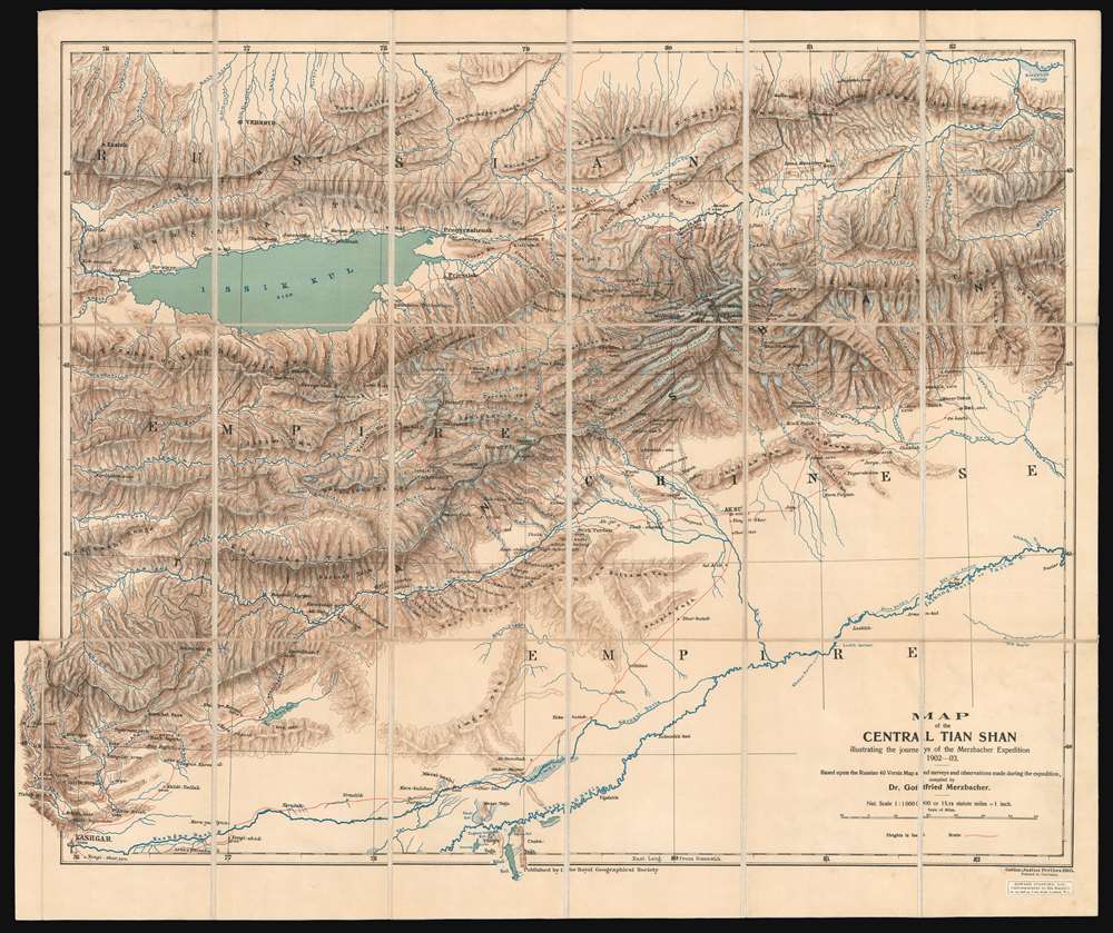
Map of the Central Tian Shan illustrating the journeys of the Merzbacher Expedition 1902 - 03.
1905 (dated) 21 x 25 in (53.34 x 63.5 cm) 1 : 1000000
1905 (dated) 21 x 25 in (53.34 x 63.5 cm) 1 : 1000000
Description
This is an extremely rare 1905 Dr. Gottfried Merzbacher map of the central Tian Shan Mountains in modern-day western China and Kyrgyzstan. It is the first map to accurately locate Khan Tengri, a nearly 23,000-foot peak known but not mapped. The map depicts the region from Kashgar to the Shakh Yar River, and from the Kunges River to Khol Kol (Khol Lake). Red lines trace the Merzbacher expedition's peregrinations through the region over a period of two years, with their ultimate goal being determining an accurate location for Khan Tengri. Settlements, rivers, and lakes encountered along their routes are labeled, but detail becomes scarcer the farther away from territory physically explored by the expedition. During their two years in the region, Merzbacher and his associates collected a trove of data, most of which is not represented here due to the desire to quickly publish the map to accompany Merzbacher's book. Glaciers, some of which the team explored on foot, while others they simply observed, are illustrated throughout. Khan Tengri, the expedition's stated goal, is illustrated and labeled above and to the right of center and is surrounded by glaciers. Unfortunately, the label on this example is bisected by the linen fold line. Issyk-Kul (Issik Kul), an endorheic lake in eastern Kyrgyzstan that is the second largest saline lake in the world, is also illustrated and labeled.
Merzbacher's Comments About the Map
Merzbacher includes some comments concerning this map at the end of the book he published about the journey, stating that it was 'a sketch-map' and did not 'profess to give a complete and accurate representation of the physical features of the Central Tian-Shan'. He notes that hundreds of barometric observations taken during the expedition had not yet been collated when this map was being prepared, so altitudes are provided as round numbers only, 'which do not claim to be absolutely accurate'. He also comments on the names presented on the map, stating that he took 'the greatest pains to ascertain the true, current names of localities, and having visited most of them repeatedly and thoroughly, I think my nomenclature has a claim to authority.'Publication History and Census
This map was compiled by Gottfried Merzbacher to accompany his book entitled The Central Tian-Shan Mountains 1902 - 1903 and was published in conjunction with the Royal Geographical Society by Justus Perthes in Germany and Edward Stanford in Britain. Only one example of the map is catalogued in OCLC and is part of the collection at the British Library. The book is well represented in institutional collections. However, both are extremely rare on the private market.CartographerS
Gottfried Merzbacher (December 9, 1843 - April 14, 1926) was a German alpinist, explorer, and geographer. Born near Erlangen, Merzbacher was the son of Marcus Merzbacher, a Jewish fur trader. He left secondary school to learn his father's trade, and eventually trained in London, St. Petersburg, and Paris. He opened a fur shop in Munich in 1868, which, after twenty years and building a successful business, he sold to devote himself entirely to alpinism. After his retirement, Merzbacher went on extensive trips worldwide, investigating Persia, Ceylon (Sri Lanka), the Caucasus, and Kashmir. In 1902-03 he led an expedition into the Tian Shan Mountains where he discovered the ice reservoir on the Inyltschek glacier that has become known as the Merzbacher See. More by this mapmaker...
Royal Geographical Society (fl. 1830 - present) is a British Society established in 1830 to promote geographical science and exploration. Originally titled the "Geographical Society of London", the RGS received its royal charter from Queen Victoria in 1859 shortly after absorbing several similar but more regional societies including the African Association, the Raleigh Club and the Palestine Association. The RGS sponsored many of the most important and exciting voyages of exploration ever undertaken, including the exploration of Charles Darwin, David Livingstone, Robert Falcon Scott, Richard F. Burton, John Speke, George Hayward, H. M Stanley, Ernest Shackleton and Sir Edmond Hillary. Today, the RGS remains a leading global sponsor of geographical and scientific studies. The Society is based in Lowther Lodge, South Kensington, London. Learn More...
Johan Georg Justus Perthes (September 11, 1749 - May 2, 1816) was one of the most important German cartographic engravers of the 19th century. He was born in the Thuringian town of Rudolstadt, the son of a court physician. In 1778, he began working as a bookseller in Gotha. Perthes began his publishing empire shortly thereafter with the 1784 issue of the famed survey of European nobility known as the Almanac de Gotha. In the next year, 1785, he founded the cartographic firm of Justus Perthes Geographische Anstalt Gotha. His son Wilhelm Perthes (1793 - 1853) joined the firm in 1814. Wilhelm had prior publishing experience at the firm of Justus Perthes' nephew, Friedrich Christoph Perthes, who ran a publishing house in Hamburg. After Justus Perthes died in 1816, Wilhelm took charge and laid the groundwork for the firm to become a cartographic publishing titan. From 1817 to 1890. the Perthes firm issued thousands of maps and more than 20 different atlases. Along with the visionary editors Hermann Berghaus (1797 - 1884), Adolph Stieler (1775 - 1836), and Karl Spruner (1803 - 1892), the Perthes firm pioneered the Hand Atlas. When Wilhelm retired, management of the firm passed to his son, Bernhardt Wilhelm Perthes (1821 – 1857). Bernhardt brought on the cartographic geniuses August Heinrich Peterman (1822 - 1878) and Bruno Hassenstein (1839 - 1902). The firm was subsequently passed to a fourth generation in the form of Berhanrd Perthes (1858 – 1919), Bernhard Wilhelm's son. The firm continued in the family until 1953 when, being in East Germany, it was nationalized and run as a state-owned enterprise as VEB Hermann Haack Geographisch-Kartographische Anstalt Gotha. The Justus family, led by Joachim Justus Perthes and his son Wolf-Jürgen Perthes, relocated to Darmstadt where they founded the Justus Perthes Geographische Verlagsanstalt Darmstadt. Learn More...
Edward Stanford (May 27, 1827 - November 3, 1904) was one of the most prolific map publishing firms of the late 19th century. The company began as a partnership in 1848 between the 21 year old Edward Stanford and the established map dealer Trelawney Saunders. By 1853 the partnership had dissolved and Edward Stanford took full control of the business. A subsequent series of expansions and exciting new map issues finally led to the production of Stanford's masterwork, "Stanford's Library Map of London". This map is still available and remains somewhat accurate. At the time of publishing it was hailed by the Royal Geographical Society as "the most perfect map of London that has ever been issued". In 1882 Edward Stanford Sr. passed the firm on to his son, Edward Stanford Jr. who continued in his father's proud tradition. Today the Stanford firm still publishes maps and remains one of the most important and prolific cartographic publishers in the world. Learn More...
Source
Merzbacher, G., The Central Tian-Shan Mountains 1902 - 1903 (London: John Murray) 1905.
Condition
Very good. Dissected and mounted on linen in 19 panels.
References
OCLC 497552456.