This is a c. 1930 Clason city plan or map of Chicago, Illinois. This map details Chicago near the end of notorious gangster Al Capone's time as boss of the Chicago Outfit.
A Closer Look
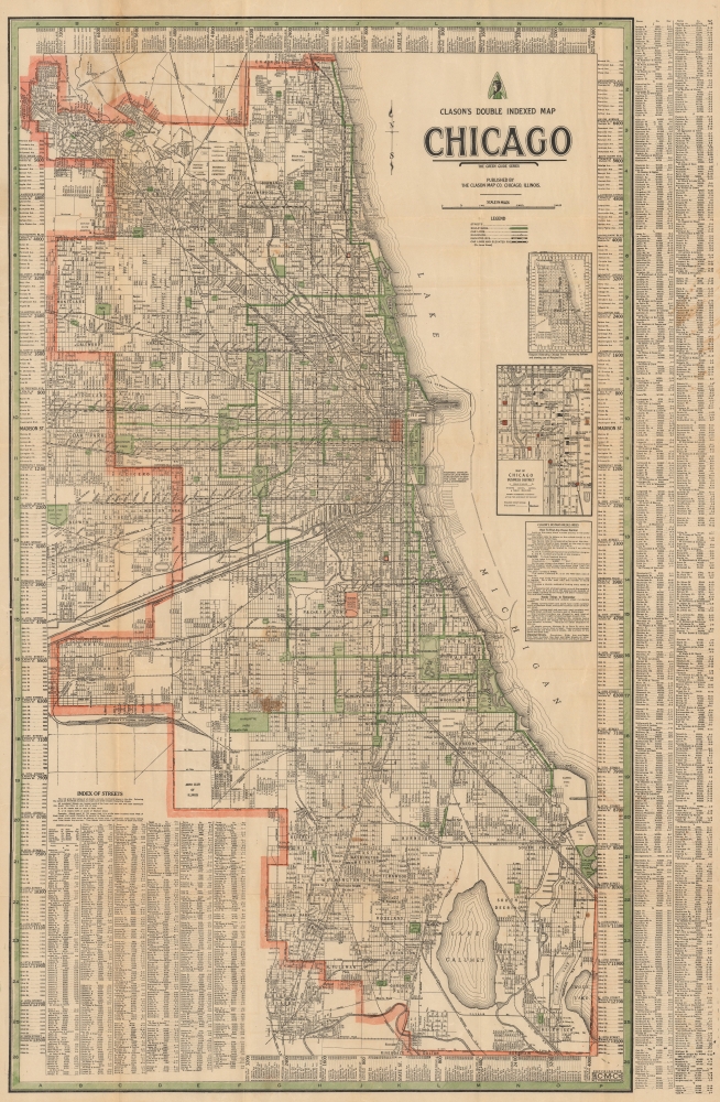
The map depicts Chicago from Evanston in the north to De Youngs, Riverdale, Dolton, and Burnham in the south and from Park Ridge in the west to Lake Michigan. City parks are shaded green, including Lincoln Park (with the zoo labeled), Grant Park, and Jackson Park. Major boulevards are also colored green. The Loop, Wrigley Field (home of the Chicago Cubs), Comiskey Park (home of the Chicago White Sox), and the Union Stock Yards are highlighted in red. A black and white dashed line follows the 'L'. An inset map along the right side details the 'Loop', labeling the Public Library, Art Institute, Grand Central Station, hotels, and theaters. A detailed street index surrounds the map.Clason's Green Guide Series (1920 - 1931)
The Clason Map Company began publishing what became known as Green Guides in 1906. The first few were local to Clason, focusing on Colorado Springs, Denver, and Colorado. Between 1907 and 1919, Clason greatly expanded the series. In 1908, the iconic green cover was introduced. That year, the series expanded to 7 states: Colorado, Arizona (1907), Idaho, Montana, New Mexico, Utah, and Wyoming. The covers of Clason's guidebooks changed several times between 1908 and 1919 but remained green. New cities were added, including Salt Lake City, Utah, and Butte, Montana. The guide was first referred to as the Green Guide in 1920, terminology that Clason adopted. The series continued to change throughout the 1920s. In 1930, the series was rebranded as 'The Green Guide Series.' The last Clason Green Guides were published in 1931.Publication History and Census
This map was created and published by the Clason Map Company c. 1930. Nine examples of a map bearing the same title are cataloged in OCLC, but few are digitized.
Cartographer
George Samuel Clason (November 7, 1874 - 1957) was born in the city of Louisiana, Missouri in 1874. As a young man, Clason studied at the University of Nebraska before joining the United States Army in 1898 to fight in the Spanish American War. After the war, he moved to Denver, Colorado where in 1905 he founded the Clason Map Company, thus starting his lucrative publishing career. Clason initially focused on mining and mineral maps - capitalizing on the Colorado and Nevada mining industry, but quickly transitioned to railroad maps, city maps, and by the 1920s, road maps. As the company expanded, Clason opened a secondary office in Chicago, Illinois - then a rising map publishing center and railroad hub. At least one other satellite office was opened in Los Angeles. Among his many achievements, Clason is credited with producing the first modern road atlas of the United States. In the late 1920s, Clason also published a series of get-rich-quick pamphlets in the form of parables. The most famous of these is The Richest Man in Babylon. This tells the story of Arkad, a citizen of Babylon famed for his great wealth and generosity who shares his wit and wisdom with his fellow Babylonians. In 1949, Clason moved to Napa, California to retire and found a social club for retired gentlemen. More by this mapmaker...
Very good. Light wear along original fold lines. Verso repairs to fold separations. Verso repairs and reinforcements at fold intersections. Slight loss at a few fold intersections. Light soiling.
Liedholm, C. 'Clason's Green Guides', The Legend No. 50, Spring 2011. (Road Map Collector's Association.) pp. 8-11. OCLC
515419689.