This item has been sold, but you can get on the Waitlist to be notified if another example becomes available, or purchase a digital scan.
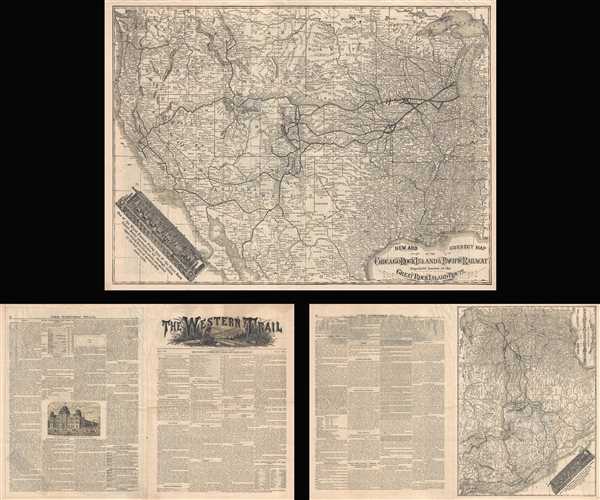
1881 Chicago, Rock Island and Pacific Railroad Map of the United States
ChicagoRockIslandPacific-westerntrail-1881$250.00

Title
New and Correct Map of the Chicago Rock Island and Pacific Railway Popularly known as the Great Rock Island Route.
1881 (dated) 13.5 x 18.25 in (34.29 x 46.355 cm) 1 : 7600000
1881 (dated) 13.5 x 18.25 in (34.29 x 46.355 cm) 1 : 7600000
Description
This is an 1881 Chicago, Rock Island, and Pacific map of the United States illustrating their rail network. Published by the railroad in the first issue of their bulletin entitled 'The Western Trail', the map depicts the United States from the Pacific Ocean to Michigan, Kentucky, Tennessee, and Georgia and from the U.S.-Canadian border to Mexico and the Gulf of Mexico. The main lines and spurs of most of the major railroads are illustrated and labeled, with the Rock Island's main lines in Illinois shown in bold lines and with every whistle stop marked and labeled. Once outside of Illinois, it became much less clear exactly which lines belong to the Rock Island, are partner lines, or are simply major railways in the western United States, like Union Pacific. Myriad cities, towns, and villages throughout the American West are labeled, along with rivers, lakes, and the Rocky and Sierra Nevada Mountains. A view of one of the 'World Famous Dining Cars of the Great Rock Island Route' is situated in the lower left corner, just off the coast of Baja California. One side of the car has been removed, allowing the viewer to get an idea of what opulence and luxury awaits them on a trip aboard the Rock Island Railway.
This map was produced by the Chicago, Rock Island, and Pacific Railway and published in the first issue of their bulletin entitled 'The Western Trail' in May 1881. This example is accompanied by the entire first issue of 'The Western Trail.
This map was produced by the Chicago, Rock Island, and Pacific Railway and published in the first issue of their bulletin entitled 'The Western Trail' in May 1881. This example is accompanied by the entire first issue of 'The Western Trail.
Source
General Ticket and Passenger Department, 'The Western Trail', Vol. 1 No. 1 (May 1881).
The Western Trail (May 1881 - c. 1894) was a newspaper produced and published by the General Ticket and Passenger Department of the Chicago, Rock Island, and Pacific Railway. Originally published in 1881, the first issue included an interesting 'salutary'
This paper is published by the General Passenger Department of the great Rock Island Route, primarily as an advertising medium. While this fact is acknowledged, it has been the aim to furnish reliable information about the great mineral region embraced within the area of the Rocky Mountain Range. Nothing but admitted facts have been given place in these columns, the company no desiring to disseminate false information or mislead those who confide in us. Therefore credence can be given to whatever is here published, and if it shall be the mean of leading any to happiness and fortune we shall be pleased, especially if they journeyed to the West over our most comfortable and famous line.
Condition
Very good. Four page newsprint bulletin. Even overall toning. Small tear perpendicular to centerfold. Text on three of four pages, map on fourth.

