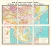
1983 Zhang Six-Sheet Tectonic Wall Map of East Asia
ChinaTectonicEnglish-zhang-1983$1,000.00


Title
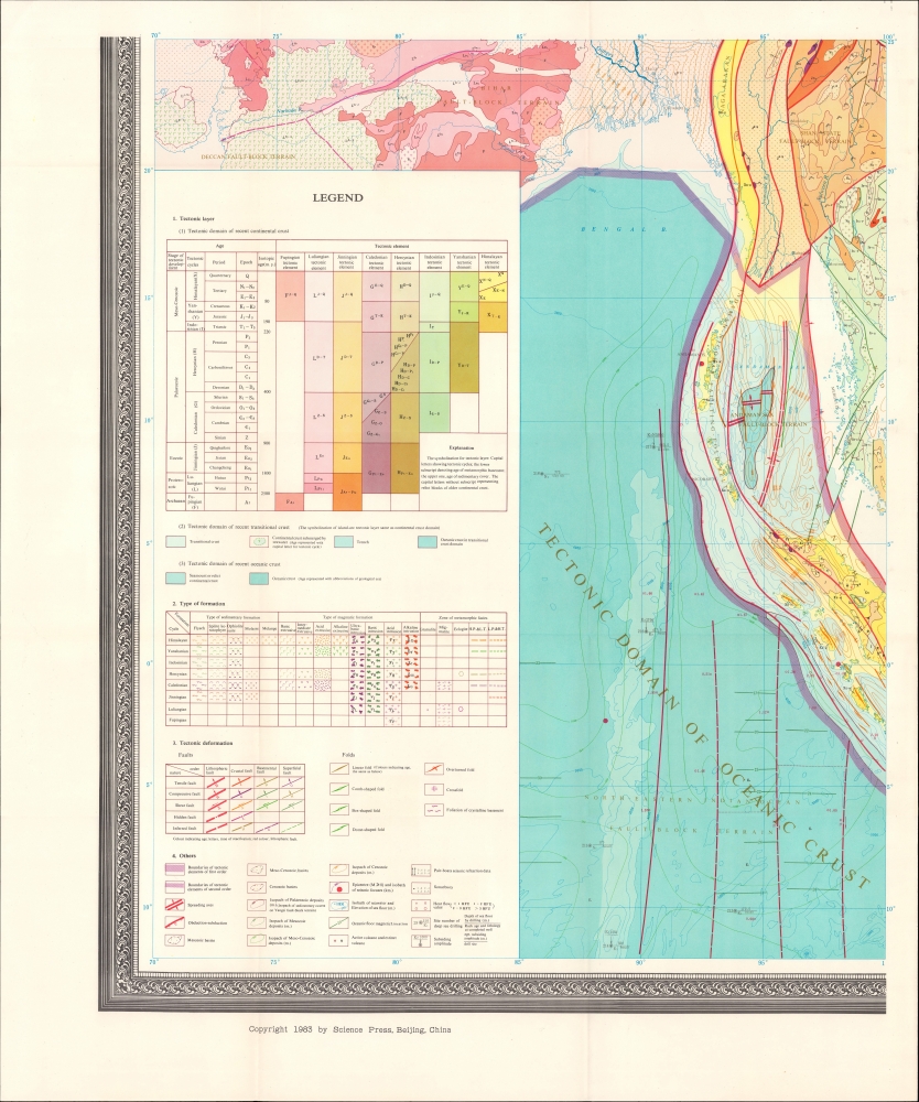
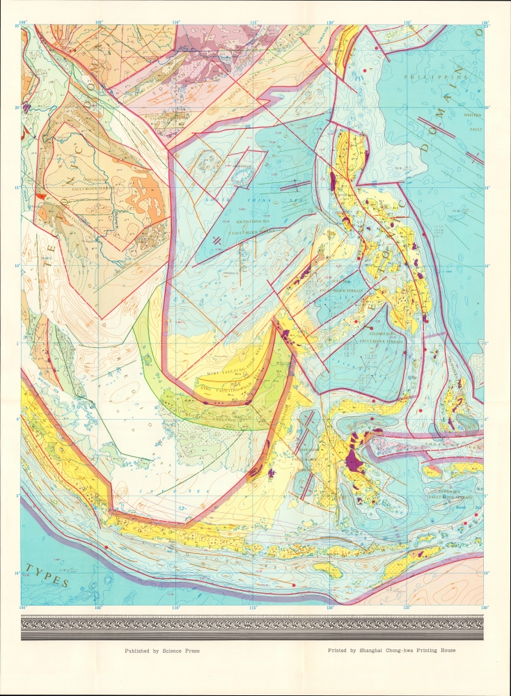
The Marine and Continental Tectonic Map of China and Its Environs.
1983 (dated) 68.25 x 72.75 in (173.355 x 184.785 cm) 1 : 5000000
1983 (dated) 68.25 x 72.75 in (173.355 x 184.785 cm) 1 : 5000000
Description
A visually impressive, very large 6-sheet tectonic wall map of China and East Asia, edited by Zhang Wenyou and published in 1983 by Sciences Press.
The end of the Cultural Revolution strengthened the reformist faction of the Chinese Communist Party, allowing Deng Xiaoping (1904 - 1997) to emerge as the main force in the Party by late 1978, setting the stage for the 'reform and opening up' agenda that has drastically changed China in the years since. Although the sciences had recovered somewhat from the most chaotic and destructive phase of the Cultural Revolution in the late 1960s, the late 1970s saw a wholesale revival of scientific and academic activity. Eager to make up for lost time, Chinese scientists built international connections, translated the latest works into Chinese, undertook ambitious research projects, like this map, and trained a new cadre of young scholars, and dedicated themselves to using science to help China reemerge as a great power.
A Closer Look
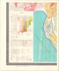
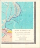
Covering from Central Asia, Mongolia, and Manchuria in the north to India and Indonesia in the south, this highly technical map uses color shading to provide geologic and tectonic information, resulting in a stunning visual presentation. Color shading and a system of letters and numbers indicate geologic eras and tectonic elements, while shades of blue provide information on ocean crusts. Additional symbols denote various types of geologic formations, tectonic deformations, and other features explained in the legend at bottom-left.Seismology and Seismic Political Shifts
Unsurprisingly for such a large country, parts of China are very earthquake-prone. The late 1960s and 1970s were particularly active , with major earthquakes in 1973 (Luhuo), 1975 (Haicheng), and 1976 (Tangshan and Songpan-Pingwu). The Tangshan Earthquake on July 28, 1976, was one of the deadliest earthquakes in Chinese history, killing some 300,000 people, perhaps many more, and flattening the city of Tangshan (the hometown of Zhang Wenyou). As the Tangshan Earthquake preceded Mao Zedong's (1893 - 1976) death by a matter of weeks and was one of the last major events of his reign, it has sometimes been seen as a portent of the significant changes that would take place in China in the following years. After Mao's death, one of his deputies, Hua Guofeng (1921 - 2008), became the nominal leader of the Chinese Communist Party, quickly turning on Mao's widow, Jiang Qing, and her allies, who were arrested and blamed for the horrors of the Cultural Revolution (which Mao instigated and led).The end of the Cultural Revolution strengthened the reformist faction of the Chinese Communist Party, allowing Deng Xiaoping (1904 - 1997) to emerge as the main force in the Party by late 1978, setting the stage for the 'reform and opening up' agenda that has drastically changed China in the years since. Although the sciences had recovered somewhat from the most chaotic and destructive phase of the Cultural Revolution in the late 1960s, the late 1970s saw a wholesale revival of scientific and academic activity. Eager to make up for lost time, Chinese scientists built international connections, translated the latest works into Chinese, undertook ambitious research projects, like this map, and trained a new cadre of young scholars, and dedicated themselves to using science to help China reemerge as a great power.
Publication History and Census
This map was compiled by a team of researchers led by geologist Zhang Wen-you (张文佑). It was published by the Chinese Academy of Sciences (CAS)-affiliated Sciences Press and printed by the Shanghai Zhonghua (Chong-hwa) Printing House. Especially given the strong connection with CAS, this map was likely influenced by Huang Jiqing et al's 'Tectonic Map of China' (previously sold by us), first published in 1979. By comparison, the present map is produced in a larger format and expands the scope to include the South China Sea (a small inset on Huang's map) and other parts of East Asia (Japan, the Korean Peninsula, Mongolia, and Southeast Asia). The present map is well represented in institutional collections but scarce on the market.CartographerS
Zhang Wen-you (张文佑; August 31, 1909 - February 11, 1985), also rendered in English as W. Y. Chang and Zhang Wenyou, was a Chinese geologist. Born in Tangshan, which became the site of a massive earthquake in 1976, Zhang studied civil engineering the Tangshan Institute of Technology and Beijing University. Afterwards, he taught at Guangxi University and the National Central University, which had relocated to Chongqing due to the Second Sino-Japanese War, and became a member of the Academia Sinica's Geological Research Committee. After the war, Zhang traveled and studied in Europe and the United States. Returning to China in the midst of the Chinese Civil War, Zhang initially traveled with the Nanjing government when it retreated to Guangzhou, but decided to stay in mainland China rather than move to Taiwan, quickly becoming the head of the new Institute of Geology at the Chinese Academy of Sciences. He also taught at Beijing University and the newly established Beijing Institute of Geology (now the China University of Geosciences). From the late 1950s, he edited a series of large-scale geological maps of China that became the standard for the field. An accomplished student of languages in addition to his scientific work, Zhang translated works by leading international geologists in Russian and English into Chinese. More by this mapmaker...
Sciences Press (科学出版社; 1954 - present) is the largest publisher of scientific and technical works in the People's Republic of China. Originally founded through the merger of the Longmen United Book Company with the Chinese Academy of Science's Compilation and Translation Bureau and operated as part of the Chinese Academy of Sciences, the company today still maintains a very strong affiliation with that institution. Its publications span the entire sciences, from human evolution to cosmology, physics, computer science, and medicine, and even into the humanities and social sciences (such as works on the history of technology). Learn More...
Shanghai Zhonghua Printing Factory (上海中华印刷厂; 1912 - present) is a printer based in Shanghai, China, known as one of the oldest and largest print factories in China. Founded in 1912 as a private company, it was nationalized after 1949, and focused on publishing works related to news, current events, and national affairs, including works designated for internal party use. However, it has printed works in many fields and is also known for its high-quality color prints for works related to painting and the arts. In 1998, the factory was privatized, and has undergone significant restructuring and modernization in recent years. Learn More...
Condition
Very good. Light wear along original folds.
References
OCLC 14718707.