This item has been sold, but you can get on the Waitlist to be notified if another example becomes available, or purchase a digital scan.
1893 Sharbau Map of Xinjiang, China and Kyrgyzstan
ChineseTurkistan-sharbau-1893$175.00

Title
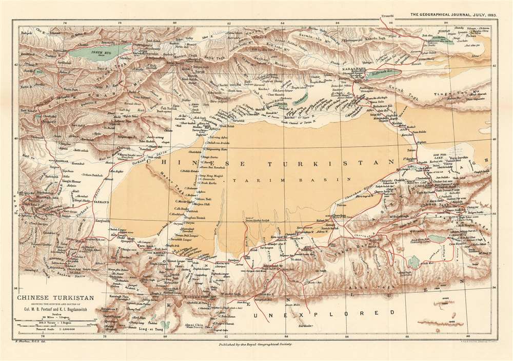
Chinese Turkistan Showing the Surveys and Routes of Col. M.B. Pevtsof and K.I. Bogdanovitch.
1893 (dated) 11.25 x 16 in (28.575 x 40.64 cm) 1 : 3800000
1893 (dated) 11.25 x 16 in (28.575 x 40.64 cm) 1 : 3800000
Description
This is an 1893 Henry Sharbau map of Xijiang Province in China and Kyrgyzstan. The map depicts the movements of the 1889 Imperial Russian Geographical Society expedition to Central Asia led by Mikhail Vasilievich Pevtsov, which are traced by the thick red line. An impressive level of detail is present. Numerous towns and villages are identified, as are rivers and mountain peaks. Issyk Kul, the second largest salt water lake in the world, is situated in the upper left corner.
The Pevtsov Expedition and Karl Ivanovich Bogdanovich
Little research has been conducted concerning the Pevtsov Expedition to Central Asia, but we have been able to piece together some of its story. Mikhail Vasilievich Pevtsov (1843 - 1902), a Russian major general, traveler, and researcher, was placed in charge of the expedition after the untimely death of noted explorer Nikolay Przhevalsky (1839 - 1888) in Karakol, on the eastern shore of Issyk Kul. Bogdanovich, the first geologist, to visit the Tarim Basin, produced numerous significant discoveries.Publication History and Census
This map was created by Henry Sharbau, printed by the firm of W. and A.K. Johnston, and published by the Royal Geographical Society to accompany E. Delmar Morgan’s article ‘The Pevtsof Expedition and M. Bogdanovitch’s Surveys’ in the July 1893 edition of The Geographical Journal. Two examples are catalogued in the OCLC as being part of the collections at the Library of Congress and The British Library.CartographerS
Henry Sharbau, (fl. 1870-1906) was a lithographer active in London and Edinburgh. While nothing is known of his early training, it is likely that his early years were spent with the navy: his earliest known works of the 1870s were on charts produced by the Hydrographic Department. The 1880s saw the beginning of a long association with the Royal Geographic Society, and then with the mapmaking firm of W. and A.K. Johnston. Over a hundred works appear in OCLC with Sharbau’s imprint. Interestingly, the British Naval Lists reveal a Frederic Henry Sharbau (1867-1963!!!) working as a cartographer and draughtsman starting about 1907 and lasting into the 20s. Perhaps this Methuselah is a son? More by this mapmaker...
Royal Geographical Society (fl. 1830 - present) is a British Society established in 1830 to promote geographical science and exploration. Originally titled the "Geographical Society of London", the RGS received its royal charter from Queen Victoria in 1859 shortly after absorbing several similar but more regional societies including the African Association, the Raleigh Club and the Palestine Association. The RGS sponsored many of the most important and exciting voyages of exploration ever undertaken, including the exploration of Charles Darwin, David Livingstone, Robert Falcon Scott, Richard F. Burton, John Speke, George Hayward, H. M Stanley, Ernest Shackleton and Sir Edmond Hillary. Today, the RGS remains a leading global sponsor of geographical and scientific studies. The Society is based in Lowther Lodge, South Kensington, London. Learn More...
Alexander Keith Johnston (December 28, 1804 - July 9, 1871) was a Scottish cartographer and map publisher active in the middle portion of the 19th century. Johnson was born at Kirkhill, near Edinburgh, Scotland. He studied at the University of Edinburgh where he apprenticed as an engraver. Around 1826, in partnership with his brother William, he founded a cartographic printing and engraving firm with the imprint "W. and A. K. Johnston." Johnston made a name for himself in educational geography, publishing numerous maps for use in schools. His brother, William Johnston, eventually left the firm to pursue a career in politics, eventually becoming the Lord Provost of Edinburgh. Alexander's son, who would bear the same name, became a geographer and explorer, suffering an untimely death on the Royal Geographical Society's 1879 expedition to Lake Nyasa. Learn More...
Source
Morgan, E.D., 'The Pevtsof Expedition and M. Bogdanovitch's Surveys'. The Geographical Journal (London: Royal Geographical Society) July 1893.
Condition
Very good. Light wear and toning along original fold lines. Blank on verso.
References
OCLC 852933805.