This item has been sold, but you can get on the Waitlist to be notified if another example becomes available.
1986 Blondel La Rougery Bird's-Eye View Map of Paris, France
CidotelParis-blondel-1986$62.50


Title
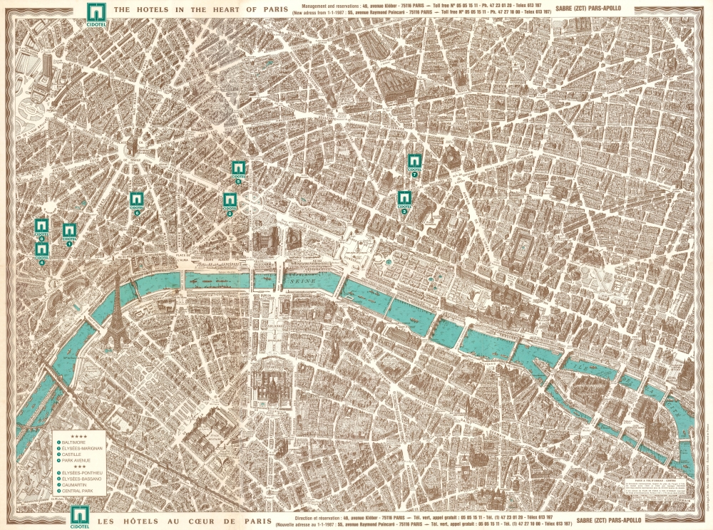
Cidotel The Hotels in the Heart of Paris. Cidotel Les Hôtels au Cœur de Paris.
1986 (dated) 22.75 x 30 in (57.785 x 76.2 cm) 1 : 6000
1986 (dated) 22.75 x 30 in (57.785 x 76.2 cm) 1 : 6000
Description
This is a 1986 Blondel la Rougery pictorial bird's-eye view map of Paris, France. The view exquisitely captures the unique architecture of Paris while serving as a helpful visual city guide.
A Closer Look
The map illustrates central Paris from the Place de la Porte Maillot to the Hotel de Ville and from Place de l'Europe to the French Senate near the Jardin du Luxembourg. Somewhat inspired by Turgot's celebrated 1739 plan of Paris, every building is illustrated from a standard oblique angle and uniform height - a model known as an axonometric projection. Les Invalides, the Louvre, Notre Dame, the Eiffel Tower, and the Arc de Triomphe, among other monuments, are thus emphasized. The bridges across the Seine River are similarly highlighted, particularly Pont Neuf, with its distinctive architecture. The Parce de Monceau is illustrated in detail, with most paths illustrated and identified.Publication History and Census
This map was created by Blondel la Rougery for the hotel Cidotel in 1986. It is derived from a map composed by Georges Peltier between 1920 and 1940. Cidotel closed in the 1990s.Cartographer
Blondel la Rougery was a French publishing house founded in Paris around 1902 by the publisher and aerophile Édouard Blondel la Rougery (July 9, 1877 - July 20, 1955). The company specialized in maps and books, particularly those related to aviation and maritime themes. Over time, Blondel la Rougery became well-known for its detailed maps, which were used extensively during both World Wars. In 1934, the firm inherited the aviation and cartographic copyrights of Georges Besançon (1866 - 1934), erstwhile publisher of L'Aérophile. In 1955, his son Max Blondel la Rougery took over the business and continued to manage it until 1976. The company continued to operate until the early 21st century, with its focus remaining largely on map production. The publisher’s works are notable for their precision and artistic quality, making them highly regarded in both historical and cartographic circles. More by this mapmaker...
Condition
Excellent.