Digital Image: 1864 Purdy Nautical Chart / Map of the Coast of China (Hong Kong, Taiwan)
CoastofChina-purdy-1865_d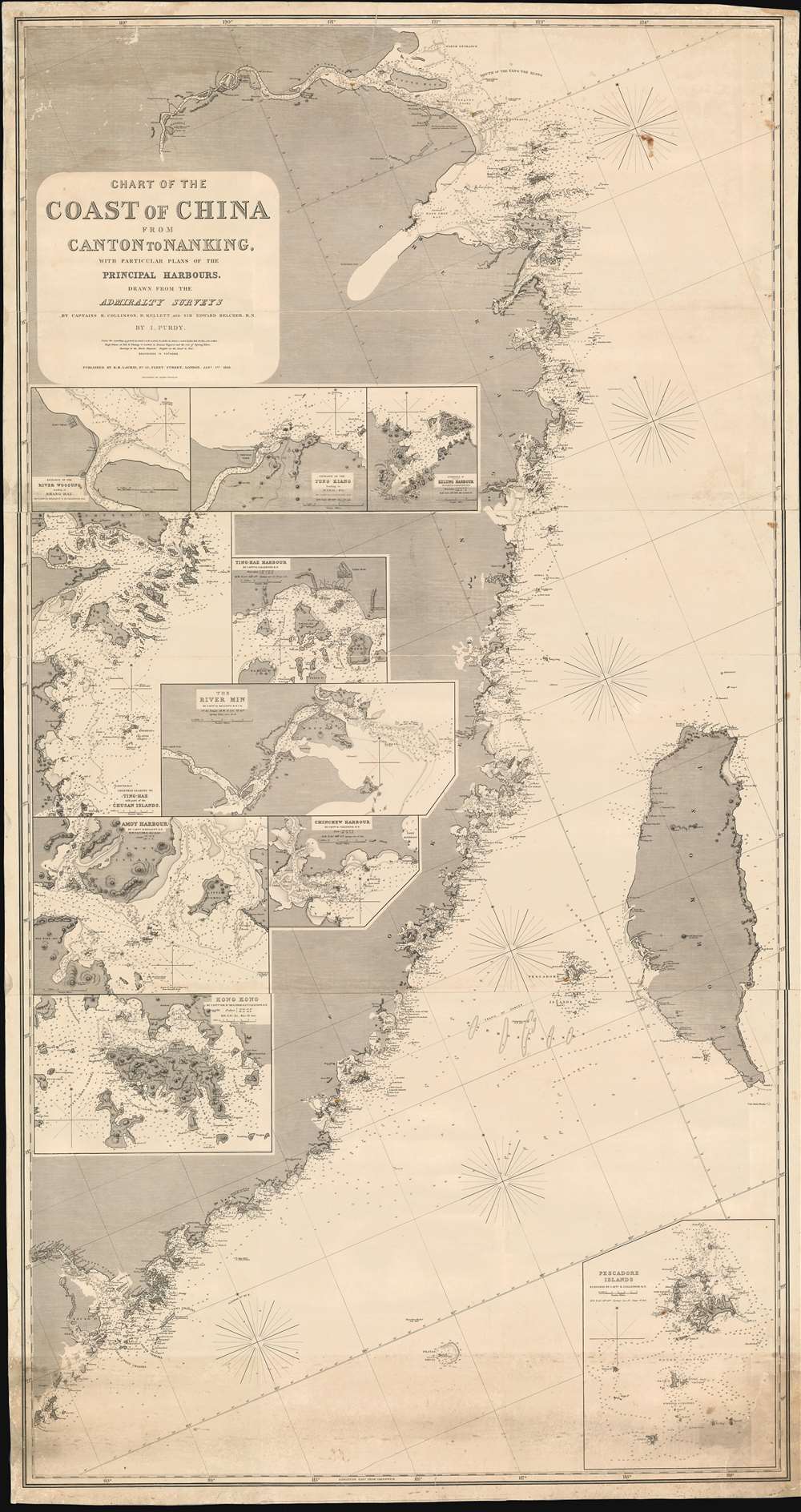

Title
Chart of the Coast of China from Canton to Nanking, with particular plans of the principal Harbors, Drawn from the Admiralty Surveys by Captains R. Collinson, H. Kellett and Sir Edwad Belcher, R. N.
1865 (dated) 73 x 38.5 in (185.42 x 97.79 cm) 1 : 855000
1865 (dated) 73 x 38.5 in (185.42 x 97.79 cm) 1 : 855000
Description
FOR THE ORIGINAL ANTIQUE MAP, WITH HISTORICAL ANALYSIS, CLICK HERE.
Digital Map Information
Geographicus maintains an archive of high-resolution rare map scans. We scan our maps at 300 DPI or higher, with newer images being 600 DPI, (either TIFF or JPEG, depending on when the scan was done) which is most cases in suitable for enlargement and printing.
Delivery
Once you purchase our digital scan service, you will receive a download link via email - usually within seconds. Digital orders are delivered as ZIP files, an industry standard file compression protocol that any computer should be able to unpack. Some of our files are very large, and can take some time to download. Most files are saved into your computer's 'Downloads' folder. All delivery is electronic. No physical product is shipped.
Credit and Scope of Use
You can use your digial image any way you want! Our digital images are unrestricted by copyright and can be used, modified, and published freely. The textual description that accompanies the original antique map is not included in the sale of digital images and remains protected by copyright. That said, we put significant care and effort into scanning and editing these maps, and we’d appreciate a credit when possible. Should you wish to credit us, please use the following credit line:
Courtesy of Geographicus Rare Antique Maps (http://www.geographicus.com).
How Large Can I Print?
In general, at 300 DPI, you should at least be able to double the size of the actual image, more so with our 600 DPI images. So, if the original was 10 x 12 inches, you can print at 20 x 24 inches, without quality loss. If your display requirements can accommodate some loss in image quality, you can make it even larger. That being said, no quality of scan will allow you to blow up at 10 x 12 inch map to wall size without significant quality loss. For more information, it is best consult a printer or reprographics specialist.
Refunds
If the high resolution image you ordered is unavailable, we will fully refund your purchase. Otherwise, digital images scans are a service, not a tangible product, and cannot be returned or refunded once the download link is used.
Cartographer S
Isaac Purdy (May 22, 1804 - September 1852) was a British hydrographer and engraver active in the second quarter of the 19th century. Purdy was born in Middlesex, England, the son of a gunsmith and the nephew of the cartographer and hydrographer John Purdy. He worked for the firm of Richard Holmes Laurie as an engraver and hydrographer before transitioning to the Admiralty sometime in 1851. Several nautical charts from the 1840s and as late as 1851, bear his imprint. He should not be confused with Isaac Purdy 2 (fl. c. 1840 - 1869), a relative and also a hydrographer. More by this mapmaker...
Alexander George Findlay (January 6, 1812 - May 3, 1875) was an English geographer and hydrographer active in London during the middle part of the 19th century. Findlay was born in London to the Findlays of Arbroath, Forfarshire, a family long associated with nautical trades. Findlay's father, Alexander Findlay (apprentice to John Russell) was one of the original fellows of the Royal Geographical Society. The son, Alexander George Findlay, devoted himself to the compilation of geographical and hydrographical works, publishing various nautical works as well as historical atlases. In 1844 he was elected a fellow of the Royal Geographical Society. Most of Findlay's early nautical work was completed in association with the London geographical and print publishing firm of Laurie and Whittle. Following the 1858 death of Richard Holmes Laurie, Findlay took over the business, republishing many updated versions of established charts well into the late 19th century. Learn More...
Richard Collinson (November 7, 1811 – September 13, 1883) was an English naval officer, marine surveyor, and Arctic explorer. He was born in Gateshead, Tyne and Wear, England, then part of Durham. He joined the Royal Navy in 1823, at age twelve, and rose in the ranks, becoming a lieutenant in 1835, commander in 1841, and captain in 1842. Collinson was a highly capable captain. He participated with distinction in the First Opium War (1839 - 1842). After the war, along with Commander Henry Kellett, he completed a series of pioneering surveys of the China coast from the Yangtze River to Hong Kong. These he completed between 1842 and 1846 while serving as commander of the HMS Plover. In 1850, he was sent north in command of the HMS Enterprise to search for survivors of the Sir John Franklin expedition. Although he came quite close, he never found Franklin's lost men and returned to England without success. Nonetheless, he was honored by the Royal Geographical Society for his surveys in the Arctic and proof that it was navigable from the Behring Strait to King William's Land. Collinson was Knighted in 1875, the same year in which he retired from active duty with the rand of Admiral. Collinson died in September of 1883. Learn More...
Sir Edward Belcher (February 27, 1799 – March 18, 1877) was a British naval officer, scientist, explorer, and marine surveyor active in the middle part of the 19th century. Belcher was born in Halifax, Nova Scotia, to a proud seafaring family. He entered the Royal Navy in 1812, at just 13 years of age. Thirteen years later, in 1825, he was assigned as official surveyor to the Frederick William Beechey expedition to the Pacific and the Bering Strait. By 1836 he was in command of his own surveying (and bombing) ship, the H.M.S. Sulphur in western Africa and the Pacific coast of South America. The Sulphur was ordered back to England via the Trans-Pacific Route in 1839. On the way, he was delayed and reassigned to China to take part in the First Opium War (1839 – 1842). During this period, on January 26 of 1841, he landed on Possession Point on the northern shore of Hong Kong Island. During this visit he made the influential first British survey of Hong Kong Harbor. On returning to England he was Knighted for his services and reassigned to the HMS Samarang to complete survey work throughout the East Indies, but most specifically in the Philippines. In 1852 he commanded the last and largest Admiralty expedition in search of the lost Arctic Explorer Sir John Franklin. The expedition had five ships, four of which were lost to the Arctic ice. Like all British naval officers who lose a ship, he was court-martialed on his return to England. Although exonerated, he never received another command. He died in London at the age of 78. Belcher is commemorated in Hong Kong through Belcher's Street, Belcher Bay and The Belcher's in Kennedy Town. His name is also commemorated in the Belcher Islands, in the Canadian Arctic. He is also commemorated with a plaque in the Admiralty Garden. Following his last active service, he was appointed Knight Commander of the Order of the Bath in 1867 and an admiral in 1872. Learn More...
References
OCLC 556904475