1823 Zea Map of Gran Colombia: Colombia, Venezuela, Ecuador, Panama
Colombia-baldwincradockjoy-1823$2,200.00

Title
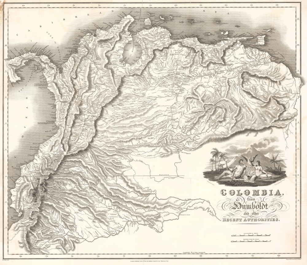
Colombia, from Humboldt and other Recent Authorities.
1823 (dated) 22.5 x 22 in (57.15 x 55.88 cm) 1 : 3801600
1823 (dated) 22.5 x 22 in (57.15 x 55.88 cm) 1 : 3801600
Description
This is the rare and important 1823' Zea Map of Colombia', one of the earliest specific maps of Gran Colombia at its height. This map was printed on behalf of the Colombian vice president under Simón Bolívar, Francisco Antonio Zea (1766 - 1822), to court European, and specifically British, investment in the new Republic, which was in dire need of financial support. The title references the naturalist Alexander von Humboldt, not for any cartographic contributions, as the map is based on the maps of John Arrowsmith, but rather for his unwavering support of an independent Gran Colombia and his promotion of its natural wealth.
A Closer Look
The map illustrates Gran Colombia at its height, under the governance of Simón Bolívar, one year after the Constitution of Cúcuta and before infighting began to tear the vast territory apart. Coverage embraces from the Pacific to the Essequibo River and from the Caribbean Sea to the Amazon, thus incorporating a vast territory including modern-day Colombia, Ecuador, Venezuela, and Panama, as well as part of Peru and Brazil. It is meticulously detailed throughout, showing roads, river systems, topography, and political boundaries. The cartography follows John Arrowsmith's large-scale general map of South America, like in its 1814 issue, but with significant updates.Ephemeral Crest
In the lower right, there is a dramatic cartouche featuring an ephemeral armorial crest proposed in 1822 to accommodate the Free Province of Guayaquil's admission into Gran Colombia. This shield was of English form, divided into three sections, each with a background reflecting the colors of the Republic's flag. In the upper section, silver stars represent departments or states. The lower left section featured an indomitable horse symbolizing freedom, while the lower right displayed a broken scepter, signifying the end of royalty. At the top of the coat of arms, an eagle (or condor) with open wings was depicted, and at the bottom, the motto 'Ser Libre o Morir' [Freedom or Death]. Surrounding the shield, on the left, a powerful bearded man armed with a mace, and on the right, a nymph. It is debated whether or not this crest was formalized, as this is one of very few examples of its use.Gran Colombia
Gran Colombia was a republic that encompassed much of northern South America, including present-day Colombia, Venezuela, Ecuador, and Panama. Established in 1819 after the successful liberation from Spanish rule, Gran Colombia was led by Simón Bolívar, a key figure in Latin America's independence movements. The Republic aimed to unite the diverse regions under a single federal government, promoting stability and prosperity. Despite initial enthusiasm, the vast territory and regional differences posed significant challenges to governance. Internal conflicts and differing visions for the future of the Republic ultimately led to its dissolution in 1831, but during its brief existence, Gran Colombia symbolized the dream of a unified and independent Latin America.Publication History and Census
This map was drawn in London under the direction of Robert Mudie and published by Baldwin, Cradock, and Jay (likely a misprint of 'Joy'), and engraved by Neele and Son. It was prepared to accompany Alexandre Walker's 1822-23 Colombia: Siendo Una Relacion Geografica, Topografica, Agricultural, Comercial, Politica …, published in London in both English and Spanish. We note about 22 examples of the book in OCLC, many with the map reinstated in facsimile. Of the separate map, OCLC cites 3 confirmed holdings.CartographerS
Aaron Arrowsmith (1750-1823), John Arrowsmith (1790-1873), and Samuel Arrowsmith. The Arrowsmith family were noted map engravers, publishers, geographers, and cartographers active in the late 18th and early 19th century. The Arrowsmith firm was founded by Aaron Arrowsmith, who was trained in surveying and engraving under John Cary and William Faden. Arrowsmith founded the Arrowsmith firm as a side business while employed by Cary. The firm specialized in large format individual issue maps containing the most up to date and sophisticated information available. Arrowsmith's work drew the attention of the Prince of Wales who, in 1810, named him Hydrographer to the Prince of Wales, and subsequently, in 1820, Hydrographer to the King. Aaron Arrowsmith was succeeded by two sons, Aaron and Samuel, who followed him in the map publication business. The Arrowsmith firm eventually fell to John Arrowsmith (1790-1873), nephew of the elder Aaron. John was a founding member of the Royal Geographical Society. The firm is best known for their phenomenal large format mappings of North America. Mount Arrowsmith, situated east of Port Alberni on Vancouver Island, British Columbia, is named for Aaron Arrowsmith and his nephew John Arrowsmith. More by this mapmaker...
Baldwin and Cradock (fl. c. 1810 - 1860) were London based publishers working in the early to mid 19th century. They are best known for their publication of the Society for the Diffusion of Useful Knowledge's ground breaking subscription atlas. They also published John Thomson's magnificent New General Atlas from 1814 - c. 1820. In addition to their cartographic corpus, the firm had wide ranging publishing interests in many other areas, including books, broadsides, and an investment in Blackwoods Magazine. They had their offices at 47 Paternoster Row, London, England. This firm also published under the imprint Baldwin, Cradock, and Joy and Cradock and Joy. Learn More...
Samuel John Neele (July 29, 1758 - May 13, 1824) was a prolific British map engraver active in the late 18th and early 19th centuries. Neele apprenticed as a printer and engraver with Harry Ashby from about 1781 to 1782 before establishing himself independently in 1785 at 352 Strand, London. The combination of business acumen and technical skill made Neele extremely successful with literally hundreds of maps to his credit. His vast corpus was composed of notable maps by most major English publishers of the period including, Haywood, Faden, Wallis, Stockdale, Arrowsmith, Thomson, Pinkerton, and Greenwood, among others. Neele's sons, James and Josiah Neele, also engravers, took over their fathers business around 1818, both becoming notable in their own right. Learn More...
Source
Walker, A., Colombia: Siendo Una Relacion Geografica, Topografica, Agricultural, Comercial, Politica…, (London: Baldwin, Cradock, Joy) 1822-23.
Condition
Very good. Minor discolorations. Margin fill, upper left corner.
References
OCLC 316358179.