1862 General Land Office Map of Colorado Territory - 2nd Official Map
ColoradoTerritory-case-1862$1,300.00

Title
Map of Colorado Territory.
1862 (dated) 17 x 23.25 in (43.18 x 59.055 cm) 1 : 1650000
1862 (dated) 17 x 23.25 in (43.18 x 59.055 cm) 1 : 1650000
Description
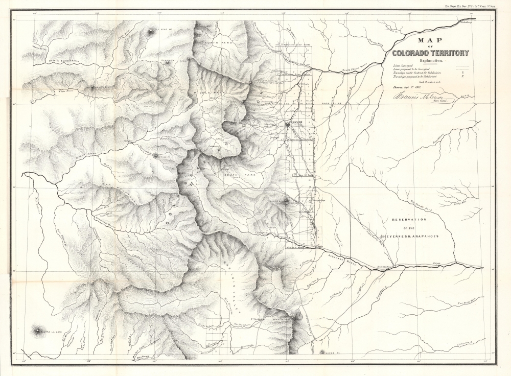
This is the 1862 map of the Colorado Territory compiled by Francis M. Case for the General Land Office. It is considered the second official map of the Colorado Territory, following Case's earlier map of 1861. The map comes at the tail end of the Pike's Peak Gold Rush, but early in Colorado's emergence as a territory.
Wheat lauds this map as a 'credible effort' offering a wealth of new information:
A Closer Look
Coverage embraces the Colorado Territory, with borders corresponding to those of the modern-day state. Denver, the regional center, appears just north of the center, linked by several major roads, including the 'New Overland Stage Route.' West of Denver, the gold region is prominently labeled, with several mining boomtowns named: Centre City, Idaho, Empire, Breckinridge, Fairplay, Oro City, Tarryall, Hamilton, and Lauret.Wheat lauds this map as a 'credible effort' offering a wealth of new information:
The Eagle Tail River has now become the Gunnison. . . . On the upper Colorado, called 'Grand River,' the former Bunkara Creek appears as Roaring Fork. White River in northwestern Colorado is represented much more correctly; and new peaks are shown, including Elk Head Mt., Claremont, Rabbit Ears, Sopris Peak, and Dome Peak. A number of new mining camps and settlements are located, but none west of the Continental Divide.
Pike's Peak Gold Rush
The Pike’s Peak Gold Rush began in 1858 and drew around 100,000 prospectors to the region in search of wealth. This influx led to the rapid development of mining camps and settlements, including Denver and Boulder. Although not matching the earlier California Gold Rush, the Pike's Peak Rush spurred fast population growth and economic development, contributing to the establishment of the Colorado Territory in 1861. The organization of the Colorado Territory was also significant in the context of the American Civil War (1861 - 1865), as it solidified Union control over the mineral-rich Rocky Mountains.Publication History and Census
This map was drawn by Francis M. Case and published for the House Documents for the 37th Congress (March 4, 1861 - March 4, 1863). We see no examples of the separate map in OCLC, but the congressional dossier for the 37th Congress is well represented. Scarce to the market.CartographerS
The General Land Office (GLO) (1812 - 1946) was an independent agency of the United States government responsible for public domain lands in the United States. Created in 1812, it took over functions previously conducted by the Department of the Treasury. The GLO oversaw the surveying, platting, and sale of public lands in the western United States. It also administered the Preemption Act of 1841, which allowed individuals who were already living on federal land to purchase up to 160 acres of land before it was offered for sale to the general public, if they met certain requirements. Following the passage of the Homestead Act in 1862, which was also administered by the GLO, claims under the Preemption Act sharply decreased. The GLO became a part of the newly-created Department of the Interior in 1849. In 1891 Grover Cleveland and Congress created 17 forest reserves, due to public concern over forest conservation, which were initially managed by the GLO, until they were transferred to the Forest Service in 1905. In 1946 the Government Land Office was merged with the United States Grazing Service to become the Bureau of Land Management. Today the Bureau of Land Management administers the roughly 246 million acres of public land remaining under federal ownership. More by this mapmaker...
Francis Mills Case (June 22, 1822 - December 12, 1892) was an American politician. Case was born in Eagleville, Ashtabula County, Ohio. He studied, first in Ohio, then in 'eastern schools' where he attained a degree in civil engineering. He first traveled to Colorado Territory in 1860 as part of the Union Pacific Railroad Survey. In March 1861, President Abraham Lincoln appointed him as the first Surveyor General of Colorado Territory. In 1870, he worked as chief engineer of the Kansas Pacific Railroad. He served as the 11th mayor of Denver, Colorado from 1873 to 1874. He was later a partner in the real estate firm Case and Ebert, through which he profited handsomely on Denver's repeated mineral booms. Case died in Findlay,, Ohio and is interred at Denver's Fairmount Cemetery Learn More...
Condition
Very good. Some wear and verso reinforcement along old fold lines. Left margin partially extended.
References
Wheat, C. I., Mapping of the Transmississippi West, 1540 – 1861, #1051. Ellis, E.H. Colorado Mapology, #18. Phillips, P.L. (Maps) p. 241.