This item has been sold, but you can get on the Waitlist to be notified if another example becomes available, or purchase a digital scan.
1844 Dower Comparative Map or Chart of the World's Mountains and Rivers
ComparativeMountainsRivers-dower-1844$150.00

Title
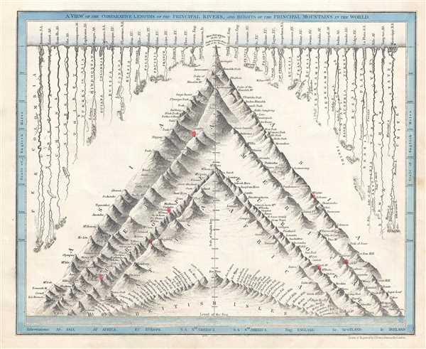
A View of the Comparative Lengths of the Principal Rivers, and Heights of the Principal Mountains in the World.
1844 (undated) 9 x 11 in (22.86 x 27.94 cm)
1844 (undated) 9 x 11 in (22.86 x 27.94 cm)
Description
This is a c. 1844 John Crane Dower comparative map or chart of the world's mountains and rivers. Charts of this kind were first introduced in England around 1823 and became a common feature in atlases throughout the 19th century.
The chart comparing the heights of the world's mountains occupies the center of the page, with the mountains divided by continent. Dower, however, separates out the British Isles, which are situated along the bottom border near sea level. Then the peaks of Africa, Europe, the Americas, and Asia are chronicled, with volcanoes marked by red plumes emitting from their summits, suggesting an eruption. The highest mountain in the world is said to be Kunchinginga at 28, 177 feet above sea level.
The comparative rivers chart occupies the space on either side of the central mountain chart, with the rivers not organized by continent, but by length. The longest is the Amazon River in South America, followed by Enisei River in Asia and the Mississippi River in the United States. Each river to illustrated in some detail, particularly in the area near its mouth.
This map was drawn and engraved by John Crane Dower c. 1844.
Cartographer
John Crane Dower (1791 - February 20, 1847) was an English engraver, map publisher, and printer active in northern London during the first half of the 19th century. Dower had his office at 6 Cumming Place, Pentonville, London. He was most active as an engraver from 1820 to 1847, where he produced work for John Greenwood, William Fowler, Henry Teesdale, Thomas Moule, Geroge Bradshaw, and others. Dower passed his business on two his two sons, John James Downer, and Fredreric Jamesd Dower. More by this mapmaker...
Condition
Very good. Even overall toning. Blank on verso.
References
Rumsey 0247.004 (1832 edition).