Digital Image: 1950 Thiriar Pictorial Map of the Democratic Republic of the Congo
Congo-thiriar-1950-2_d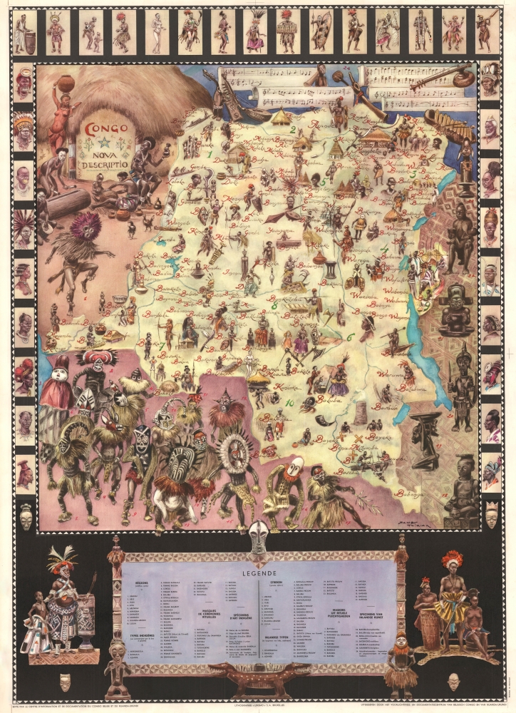

Title
Congo Nova Descriptio.
1950 (undated) 41 x 30 in (104.14 x 76.2 cm) 1 : 3500000
1950 (undated) 41 x 30 in (104.14 x 76.2 cm) 1 : 3500000
Description
FOR THE ORIGINAL ANTIQUE MAP, WITH HISTORICAL ANALYSIS, CLICK HERE.
Digital Map Information
Geographicus maintains an archive of high-resolution rare map scans. We scan our maps at 300 DPI or higher, with newer images being 600 DPI, (either TIFF or JPEG, depending on when the scan was done) which is most cases in suitable for enlargement and printing.
Delivery
Once you purchase our digital scan service, you will receive a download link via email - usually within seconds. Digital orders are delivered as ZIP files, an industry standard file compression protocol that any computer should be able to unpack. Some of our files are very large, and can take some time to download. Most files are saved into your computer's 'Downloads' folder. All delivery is electronic. No physical product is shipped.
Credit and Scope of Use
You can use your digial image any way you want! Our digital images are unrestricted by copyright and can be used, modified, and published freely. The textual description that accompanies the original antique map is not included in the sale of digital images and remains protected by copyright. That said, we put significant care and effort into scanning and editing these maps, and we’d appreciate a credit when possible. Should you wish to credit us, please use the following credit line:
Courtesy of Geographicus Rare Antique Maps (http://www.geographicus.com).
How Large Can I Print?
In general, at 300 DPI, you should at least be able to double the size of the actual image, more so with our 600 DPI images. So, if the original was 10 x 12 inches, you can print at 20 x 24 inches, without quality loss. If your display requirements can accommodate some loss in image quality, you can make it even larger. That being said, no quality of scan will allow you to blow up at 10 x 12 inch map to wall size without significant quality loss. For more information, it is best consult a printer or reprographics specialist.
Refunds
If the high resolution image you ordered is unavailable, we will fully refund your purchase. Otherwise, digital images scans are a service, not a tangible product, and cannot be returned or refunded once the download link is used.
Cartographer
James Thiriar (January 11, 1889 - October 12, 1965) was a Belgian illustrator, draughtsman, painter, and costume designer. Born in Ixelles, Belgium, Thiriar was a member of the Belgian Civil Guard, a group tasked with civil law and order, at the outbreak of World War I (1914 - 1918). Wounded while fighting with the Civil Guards against the German invasion, he joined the Belgian Army in London. His first job for the Belgian Army was with the Topographic Service, where he created detailed maps and sketches of the frontlines. Thiriar was later transferred to the artistic section, where he produced drawings of the everyday lives of soldiers, many of which were published in The Illustrated London News. He organized exhibitions of his drawings in La Panne and London in 1917 and, under the pseudonym Uilenspiegel, his work appeared in the Belgian French-language magazine L'Yser: Journal Hebdomadaire du Front Belge. His work was also published in the bi-monthly French magazine La Guerre des Nations under the title La guerre sur l'Yser dessinée. He also illustrated Jacques Pirenne's 1917 book Les Vainqueurs de l'Yser. He published his own memoirs about the war, which he also illustrated, entitled Gloire et Misère au Front de Flandres 1914 - 1918. He opened his own studio in Brussels shortly after the war and worked as a costume designer for the Théàtre Royal de la Monnaie and worked for several other theater companies. He also worked on set designs and created advertisements for the SNCF. Thiriar participated in the 1932 Belgian exploratory mission to Ruwenzori and painted several notable watercolors and gouaches of vegetation in Congo and Sudan. He provided 232 illustrations for Fernand Gendarme's three-volume work Croquis Congolais in 1942. More by this mapmaker...
References
OCLC 995849861.